TopoQuest Logo
Do you find TopoQuest useful?
Help keep TopoQuest running and adding new maps/features by donating!
Bitcoin:  19c7KJd3qBynnjoSw5npx9KScwjBe4ifkT
Litecoin:  LXs6TkuXGGXo1vDsWCkWVdjQX94eUKd6ui
Home View Maps Find Maps Find Places Resources & Links


Farrar, Texas Topographic Map

USGS Map Title: Farrar, TX
USGS Map MRC: 31096D3
DRG (GeoTIFF) Download: o31096d3.tif


Neighboring USGS Topographic Map Quads:


  Fallon, TX  
31096E4
 

  Teague South, TX  
31096E3
 

  Dew, TX  
31096E2
 

  Box Church, TX  
31096D4
 

  Farrar, TX  
31096D3
 

  Donie, TX  
31096D2
 

  Oletha, TX  
31096C4
 

  Round Prairie, TX  
31096C3
 

  Jewett, TX  
31096C2


Map MRC Location:

N32°
W97°
N32°
W96°
H8 H7 H6 H5 H4 H3 H2 H1
G8 G7 G6 G5 G4 G3 G2 G1
F8 F7 F6 F5 F4 F3 F2 F1
E8 E7 E6 E5 E4 E3 E2 E1
D8 D7 D6 D5 D4 D3 D2 D1
C8 C7 C6 C5 C4 C3 C2 C1
B8 B7 B6 B5 B4 B3 B2 B1
A8 A7 A6 A5 A4 A3 A2 A1
N31°
W97°
N31°
W96°

Farrar, TX USGS 1:24K Topographic Map Preview:
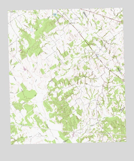
Farrar, TX USGS Topographic Map
Click on map above to begin viewing in our Map Viewer.

This topographic map contains these locations and features:
Feature Name Type Latitude Longitude GNIS ID View Map
Bear BranchStreamN31.4921°W96.2575°1372431View Map
Big CreekStreamN31.4168°W96.3480°1372542View Map
Coots BranchStreamN31.4385°W96.3152°1373206View Map
Dooley CreekStreamN31.4243°W96.3628°1373428View Map
Dry CreekStreamN31.4771°W96.2791°1373467View Map
East Lake Limestone Volunteer Fire DepartmentBuildingN31.3898°W96.3032°2552671View Map
Ezell BranchStreamN31.4843°W96.3416°1373687View Map
Fair OaksPopulated PlaceN31.4868°W96.3075°1380849View Map
FarrarPopulated PlaceN31.4568°W96.2808°1380852View Map
Gibson BranchStreamN31.4996°W96.3505°1373836View Map
Holt CemeteryCemeteryN31.4705°W96.2802°1374117View Map
Kennedy DamDamN31.4952°W96.3319°1856310View Map
Kennedy LakeReservoirN31.4950°W96.3236°1374359View Map
Lost PrairiePopulated PlaceN31.4988°W96.3719°2034732View Map
Lost Prairie ChurchChurchN31.4991°W96.3714°1374746View Map
Lynn CreekStreamN31.4005°W96.2605°1374768View Map
New HopePopulated PlaceN31.4113°W96.2814°1380890View Map
New Hope CemeteryCemeteryN31.4152°W96.2833°1699878View Map
Oaks CemeteryCemeteryN31.4905°W96.3022°1375251View Map
Pear BranchStreamN31.4405°W96.3503°1375384View Map
Pinoak CreekStreamN31.4816°W96.2736°1375477View Map
Sand BranchStreamN31.3863°W96.3461°1375985View Map
Sanders CreekStreamN31.4224°W96.3444°1375995View Map
Sassafras BranchStreamN31.4393°W96.3728°1376022View Map
Sims LakeReservoirN31.4809°W96.3494°1856309View Map
Sims Lake DamDamN31.4802°W96.3486°1856308View Map
West Lake Limestone Volunteer Fire DepartmentBuildingN31.3771°W96.3476°2552551View Map

Note: Coordinates in the location and feature list above are referenced to NAD83 datum.


Copyright (C) 2008-2025 Ryan Niemi / Sunset Dynamics ... All Rights Reserved