TopoQuest Logo
Do you find TopoQuest useful?
Help keep TopoQuest running and adding new maps/features by donating!
Bitcoin:  19c7KJd3qBynnjoSw5npx9KScwjBe4ifkT
Litecoin:  LXs6TkuXGGXo1vDsWCkWVdjQX94eUKd6ui
Home View Maps Find Maps Find Places Resources & Links


Felps, Louisiana Topographic Map

USGS Map Title: Felps, LA
USGS Map MRC: 30090H8
DRG (GeoTIFF) Download: o30090h8.tif


Neighboring USGS Topographic Map Quads:


  Centreville, MS  
31091A1
 

  Berwick, MS  
31090A8
 

  Street, MS  
31090A7
 

  Wilson, LA  
30091H1
 

  Felps, LA  
30090H8
 

  Chipola, LA  
30090H7
 

  Clinton, LA  
30091G1
 

  Bluff Creek, LA  
30090G8
 

  Hatchersville, LA  
30090G7


Map MRC Location:

N31°
W91°
N31°
W90°
H8 H7 H6 H5 H4 H3 H2 H1
G8 G7 G6 G5 G4 G3 G2 G1
F8 F7 F6 F5 F4 F3 F2 F1
E8 E7 E6 E5 E4 E3 E2 E1
D8 D7 D6 D5 D4 D3 D2 D1
C8 C7 C6 C5 C4 C3 C2 C1
B8 B7 B6 B5 B4 B3 B2 B1
A8 A7 A6 A5 A4 A3 A2 A1
N30°
W91°
N30°
W90°

Felps, LA USGS 1:24K Topographic Map Preview:
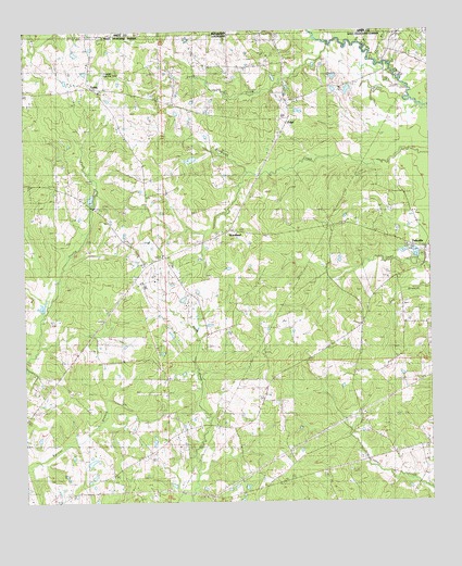
Felps, LA USGS Topographic Map
Click on map above to begin viewing in our Map Viewer.

This topographic map contains these locations and features:
Feature Name Type Latitude Longitude GNIS ID View Map
Beech Grove CemeteryCemeteryN30.8974°W90.9537°532880View Map
Beech Grove ChurchChurchN30.8946°W90.9462°532882View Map
Beech Grove School (historical)SchoolN30.8957°W90.9420°550099View Map
Camp AtakapaLocaleN30.9863°W90.9534°550103View Map
Camp AvondaleLocaleN30.8774°W90.9662°550104View Map
Clear Creek African Methodist Episcopal ChurchChurchN30.9368°W90.8770°1953274View Map
Clear Creek School (historical)SchoolN30.9368°W90.8770°550105View Map
Clinton Lookout TowerTowerN30.8768°W90.9451°558752View Map
Crooked BranchStreamN30.9924°W90.8909°534262View Map
Day SchoolSchoolN30.8877°W90.8859°534418View Map
Days ChapelChurchN30.8871°W90.8857°550109View Map
Doughty CemeteryCemeteryN30.9510°W90.8898°534571View Map
Dunn CreekStreamN30.9977°W90.9034°554300View Map
East Feliciana Elementary School (historical)SchoolN30.9380°W90.9547°2740735View Map
Eighth Ward SchoolSchoolN30.9385°W90.9548°534782View Map
FelixvillePopulated PlaceN30.9424°W90.8768°543198View Map
Felixville Post Office (historical)Post OfficeN30.9280°W90.8840°1629940View Map
FelpsPopulated PlaceN30.9771°W90.9187°543199View Map
First United Pentecostal ChurchChurchN30.8768°W90.9395°2601996View Map
Freeman Landing StripAirportN30.9880°W90.9748°550114View Map
Gerald CemeteryCemeteryN30.9466°W90.9720°535204View Map
Greater Macedonia Baptist ChurchChurchN30.8789°W90.9559°2601836View Map
Hepzibah Church (historical)ChurchN30.8946°W90.8993°550117View Map
Holland Lake DamDamN30.9668°W90.9484°556769View Map
Holy Grove PlantationLocaleN30.9235°W90.9895°550120View Map
Kent CemeteryCemeteryN30.9555°W90.9812°536175View Map
Kents Store (historical)Populated PlaceN30.8793°W90.9259°550127View Map
Littlefield Airport (historical)AirportN30.8780°W90.9934°1632665View Map
Macedonia ChurchChurchN30.8793°W90.9557°536797View Map
Mount Calvary ChurchChurchN30.9841°W90.9765°550132View Map
Mount Carmel ChurchChurchN30.9407°W90.9576°550133View Map
Pineville School (historical)SchoolN30.9655°W90.9982°550137View Map
Poverty BayouStreamN30.9607°W90.9776°550140View Map
TeddyPopulated PlaceN30.9843°W90.9768°541198View Map
Troy (historical)Populated PlaceN30.9949°W90.8873°550146View Map
Union ChurchChurchN30.9491°W90.9195°540089View Map
Union School (historical)SchoolN30.9330°W90.9043°550147View Map
Ward EightCivilN30.9402°W90.8820°545020View Map
Wattles BranchStreamN30.9168°W90.9959°550149View Map
WoodlandPopulated PlaceN30.9474°W90.9362°543796View Map
Woodland Church (historical)ChurchN30.9835°W90.9195°550152View Map
Woodland Community CenterBuildingN30.9380°W90.9547°2740733View Map
Woodland Volunteer Fire DepartmentBuildingN30.9402°W90.9554°2691839View Map
Woody Perkins Lake DamDamN30.9852°W90.9001°556768View Map

Note: Coordinates in the location and feature list above are referenced to NAD83 datum.


Copyright (C) 2008-2025 Ryan Niemi / Sunset Dynamics ... All Rights Reserved