TopoQuest Logo
Do you find TopoQuest useful?
Help keep TopoQuest running and adding new maps/features by donating!
Bitcoin:  19c7KJd3qBynnjoSw5npx9KScwjBe4ifkT
Litecoin:  LXs6TkuXGGXo1vDsWCkWVdjQX94eUKd6ui
Home View Maps Find Maps Find Places Resources & Links


Berwick, Mississippi Topographic Map

USGS Map Title: Berwick, MS
USGS Map MRC: 31090A8
DRG (GeoTIFF) Download: o31090a8.tif


Neighboring USGS Topographic Map Quads:


  Gloster, MS  
31091B1
 

  Bewelcome, MS  
31090B8
 

  Liberty, MS  
31090B7
 

  Centreville, MS  
31091A1
 

  Berwick, MS  
31090A8
 

  Street, MS  
31090A7
 

  Wilson, LA  
30091H1
 

  Felps, LA  
30090H8
 

  Chipola, LA  
30090H7


Map MRC Location:

N32°
W91°
N32°
W90°
H8 H7 H6 H5 H4 H3 H2 H1
G8 G7 G6 G5 G4 G3 G2 G1
F8 F7 F6 F5 F4 F3 F2 F1
E8 E7 E6 E5 E4 E3 E2 E1
D8 D7 D6 D5 D4 D3 D2 D1
C8 C7 C6 C5 C4 C3 C2 C1
B8 B7 B6 B5 B4 B3 B2 B1
A8 A7 A6 A5 A4 A3 A2 A1
N31°
W91°
N31°
W90°

Berwick, MS USGS 1:24K Topographic Map Preview:
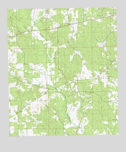
Berwick, MS USGS Topographic Map
Click on map above to begin viewing in our Map Viewer.

This topographic map contains these locations and features:
Feature Name Type Latitude Longitude GNIS ID View Map
Antioch CemeteryCemeteryN31.0560°W90.8860°689801View Map
Antioch ChurchChurchN31.0566°W90.8876°666295View Map
ArielPopulated PlaceN31.1007°W90.9873°666358View Map
Berry CreekStreamN31.0502°W90.9479°692542View Map
BerwickPopulated PlaceN31.1099°W90.9295°691700View Map
Bethany CemeteryCemeteryN31.1018°W90.9876°685208View Map
Bethany ChurchChurchN31.1021°W90.9868°666861View Map
Bethany Institute (historical)SchoolN31.1024°W90.9857°707316View Map
Bethel Baptist ChurchChurchN31.0718°W90.8820°666897View Map
Bethel CemeteryCemeteryN31.0710°W90.8812°689808View Map
Bethel CemeteryCemeteryN31.0713°W90.8815°685211View Map
Callender CemeteryCemeteryN31.0729°W90.8843°667922View Map
CapellPopulated PlaceN31.0249°W90.9879°691748View Map
Causey CemeteryCemeteryN31.1246°W90.9251°685229View Map
Centreville CreekStreamN31.0468°W90.9473°668289View Map
Centreville CreekStreamN31.0471°W90.9479°689783View Map
Crawford BranchStreamN31.0638°W90.9848°668935View Map
Crawford CemeteryCemeteryN31.0532°W90.9940°685241View Map
Dixon CemeteryCemeteryN31.0963°W90.9993°707319View Map
Duck CemeteryCemeteryN31.0643°W90.8912°685249View Map
Dunn-Hefner CemeteryCemeteryN31.0607°W90.8909°685251View Map
Ebenezer Baptist ChurchChurchN31.0382°W90.9304°669641View Map
Ebenezer CemeteryCemeteryN31.0379°W90.9298°685253View Map
Ebenezer CemeteryCemeteryN31.0382°W90.9298°689802View Map
Election BranchStreamN31.0505°W90.9620°669715View Map
Ellis CreekStreamN31.1107°W90.9679°693169View Map
Forest School (historical)SchoolN31.0680°W90.9043°685265View Map
Garner CemeteryCemeteryN31.0810°W90.9426°670321View Map
Hermon Jackson Lake DamDamN31.1135°W90.9601°680578View Map
Hughes Store (historical)LocaleN31.0427°W90.9198°711469View Map
Issac Jackson CemeteryCemeteryN31.1027°W90.9251°685302View Map
Jerusalem CemeteryCemeteryN31.1202°W90.8909°689806View Map
Jerusalem CemeteryCemeteryN31.1202°W90.8907°685307View Map
Jerusalem ChurchChurchN31.1171°W90.8951°671852View Map
John F Piker Lake DamDamN31.0152°W90.9701°680545View Map
Little Antioch CemeteryCemeteryN31.0561°W90.8858°685319View Map
McCoy CemeteryCemeteryN31.0754°W90.9482°673316View Map
Memorial CemeteryCemeteryN31.0213°W90.9920°689804View Map
Mill CreekStreamN31.0155°W90.9307°673594View Map
Millers Store (historical)LocaleN31.0213°W90.9907°685333View Map
New Hope Baptist ChurchChurchN31.1218°W90.9540°674677View Map
New Hope CemeteryCemeteryN31.0416°W90.9582°689805View Map
New Hope CemeteryCemeteryN31.0413°W90.9579°674656View Map
New Hope CemeteryCemeteryN31.1216°W90.9518°685348View Map
New Hope Church (historical)ChurchN31.0407°W90.9587°685349View Map
OlioPopulated PlaceN31.0546°W90.9212°692125View Map
Rainey CemeteryCemeteryN31.1007°W90.9251°685373View Map
Ramsey CreekStreamN31.0732°W90.9976°676466View Map
Rose Hill CemeteryCemeteryN31.0316°W90.9770°676844View Map
Rose Hill Church (historical)ChurchN31.0310°W90.9782°685385View Map
Saint Marys ChurchChurchN31.0138°W90.8795°677148View Map
Seabury CreekStreamN31.0930°W90.9604°694735View Map
Section BranchStreamN31.0074°W90.9193°677496View Map
Smiley CemeteryCemeteryN31.1179°W90.9904°677888View Map
Smylie CemeteryCemeteryN31.1016°W90.9507°685394View Map
Spears CemeteryCemeteryN31.0049°W90.9648°685396View Map
Spring Hill CemeteryCemeteryN31.0910°W90.9326°689807View Map
Spring Hill CemeteryCemeteryN31.0910°W90.9301°685398View Map
Spring Hill ChurchChurchN31.0916°W90.9307°678107View Map
Street Volunteer Fire DepartmentBuildingN31.0652°W90.8888°2667923View Map
Supervisor District 2CivilN31.0832°W90.9634°711770View Map
Talbot School (historical)SchoolN31.0110°W90.8807°685403View Map
Tolers (historical)LocaleN31.0905°W90.8918°685417View Map
Unity CemeteryCemeteryN31.0613°W90.8923°679130View Map
Unity ChurchChurchN31.0660°W90.8882°679133View Map
White Store (historical)LocaleN31.0677°W90.9132°685432View Map
William Jackson CemeteryCemeteryN31.0974°W90.9268°685434View Map
Womack CemeteryCemeteryN31.0296°W90.9259°690626View Map
Womack CemeteryCemeteryN31.0299°W90.9265°689803View Map

Note: Coordinates in the location and feature list above are referenced to NAD83 datum.


Copyright (C) 2008-2025 Ryan Niemi / Sunset Dynamics ... All Rights Reserved