TopoQuest Logo
Do you find TopoQuest useful?
Help keep TopoQuest running and adding new maps/features by donating!
Bitcoin:  19c7KJd3qBynnjoSw5npx9KScwjBe4ifkT
Litecoin:  LXs6TkuXGGXo1vDsWCkWVdjQX94eUKd6ui
Home View Maps Find Maps Find Places Resources & Links


Centreville, Mississippi Topographic Map

USGS Map Title: Centreville, MS
USGS Map MRC: 31091A1
DRG (GeoTIFF) Download: o31091a1.tif


Neighboring USGS Topographic Map Quads:


  Wilkinson, MS  
31091B2
 

  Gloster, MS  
31091B1
 

  Bewelcome, MS  
31090B8
 

  Newtonia, MS  
31091A2
 

  Centreville, MS  
31091A1
 

  Berwick, MS  
31090A8
 

  Rogillioville, LA  
30091H2
 

  Wilson, LA  
30091H1
 

  Felps, LA  
30090H8


Map MRC Location:

N32°
W92°
N32°
W91°
H8 H7 H6 H5 H4 H3 H2 H1
G8 G7 G6 G5 G4 G3 G2 G1
F8 F7 F6 F5 F4 F3 F2 F1
E8 E7 E6 E5 E4 E3 E2 E1
D8 D7 D6 D5 D4 D3 D2 D1
C8 C7 C6 C5 C4 C3 C2 C1
B8 B7 B6 B5 B4 B3 B2 B1
A8 A7 A6 A5 A4 A3 A2 A1
N31°
W92°
N31°
W91°

Centreville, MS USGS 1:24K Topographic Map Preview:
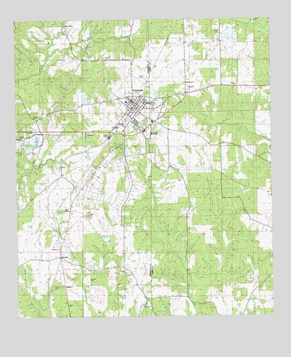
Centreville, MS USGS Topographic Map
Click on map above to begin viewing in our Map Viewer.

This topographic map contains these locations and features:
Feature Name Type Latitude Longitude GNIS ID View Map
Anderson CemeteryCemeteryN31.1202°W91.0245°666253View Map
Barch Hill Church (historical)ChurchN31.0432°W91.0140°685199View Map
Boatner CemeteryCemeteryN31.0374°W91.0379°685212View Map
Boatner School (historical)SchoolN31.0041°W91.0590°685213View Map
Carruths Store (historical)LocaleN31.0102°W91.0090°685224View Map
CentrevillePopulated PlaceN31.0896°W91.0684°668288View Map
Centreville AcademySchoolN31.0771°W91.0584°690812View Map
Centreville CemeteryCemeteryN31.0891°W91.0576°685232View Map
Centreville Police DepartmentBuildingN31.0874°W91.0665°2754214View Map
Centreville Post OfficePost OfficeN31.0876°W91.0654°2768727View Map
Centreville Volunteer Fire DepartmentBuildingN31.0798°W91.0615°2667757View Map
Elysian Fields (historical)LocaleN31.0891°W91.0251°685256View Map
Emberhill CemeteryCemeteryN31.0752°W91.1229°689789View Map
Emberhill ChurchChurchN31.0746°W91.1229°669759View Map
Embre CemeteryCemeteryN31.0699°W91.1229°690813View Map
Embre CemeteryCemeteryN31.0696°W91.1234°689793View Map
Field Memorial Community HospitalHospitalN31.0907°W91.0679°707615View Map
Finch Elementary SchoolSchoolN31.0805°W91.0762°711577View Map
Gaulden CemeteryCemeteryN31.0182°W91.0712°670339View Map
Hamilton CemeteryCemeteryN31.0657°W91.0504°685285View Map
Henry W Darden Lake DamDamN31.0435°W91.1068°680556View Map
Holly Grove CemeteryCemeteryN31.0979°W91.0420°685295View Map
Holly Grove CemeteryCemeteryN31.0979°W91.0426°689788View Map
Holly Grove ChurchChurchN31.0980°W91.0423°671316View Map
Huff CemeteryCemeteryN31.0779°W91.1162°690814View Map
Huff CemeteryCemeteryN31.0807°W91.1168°689790View Map
James Anderson CemeteryCemeteryN31.1238°W91.0445°685304View Map
Lorio Lake DamDamN31.0168°W91.0101°680547View Map
Lyons Lake DamDamN31.1035°W91.0168°680575View Map
McGraw CemeteryCemeteryN31.0838°W91.1173°673364View Map
Mount Olive CemeteryCemeteryN31.0285°W91.1051°689786View Map
Mount Olive ChurchChurchN31.0288°W91.1048°690815View Map
Mount Zion CemeteryCemeteryN31.0979°W91.0162°685346View Map
Mount Zion CemeteryCemeteryN31.0979°W91.0168°689787View Map
Mount Zion ChurchChurchN31.0980°W91.0157°674328View Map
Nathaniel CemeteryCemeteryN31.0132°W91.1037°689785View Map
Nathaniel ChurchChurchN31.0130°W91.1021°674520View Map
Norwood CemeteryCemeteryN31.0157°W91.0893°674980View Map
Oaklawn CemeteryCemeteryN31.0896°W91.0573°689794View Map
Old Centreville (historical)LocaleN31.0932°W91.0418°685360View Map
Packnett CemeteryCemeteryN31.0696°W91.1173°690817View Map
Packnett CemeteryCemeteryN31.0691°W91.1182°689791View Map
Petty CemeteryCemeteryN31.1085°W91.0704°675665View Map
Petty CemeteryCemeteryN31.1085°W91.0793°675666View Map
Redhead CemeteryCemeteryN31.0632°W91.1040°690818View Map
Redhead CemeteryCemeteryN31.0632°W91.1043°689792View Map
Rose Hill (historical)LocaleN31.0030°W91.0307°685384View Map
Sims CemeteryCemeteryN31.1207°W91.1020°677833View Map
Smith CreekStreamN31.1105°W91.1101°694826View Map
Snow Hill ChurchChurchN31.0046°W91.0632°677964View Map
Spears CemeteryCemeteryN31.0152°W91.0026°685395View Map
Stafford CemeteryCemeteryN31.0716°W91.0659°678201View Map
Stafford CreekStreamN31.0063°W91.0398°678202View Map
Town of CentrevilleCivilN31.0870°W91.0654°2406250View Map
West Fork Little Comite CreekStreamN31.0016°W91.1090°689784View Map
WhitakerPopulated PlaceN31.0255°W91.1037°692321View Map
White Castle ChurchChurchN31.1232°W91.1023°679570View Map
White CemeteryCemeteryN31.0449°W91.1018°679572View Map
William Winans Attendance CenterSchoolN31.0935°W91.0645°707618View Map
Winans CemeteryCemeteryN31.1004°W91.0657°679777View Map
WSLL-AM (Centreville)TowerN31.1021°W91.0409°680069View Map
WZZB-FM (Centreville)TowerN31.1021°W91.0409°680181View Map

Note: Coordinates in the location and feature list above are referenced to NAD83 datum.


Copyright (C) 2008-2025 Ryan Niemi / Sunset Dynamics ... All Rights Reserved