TopoQuest Logo
Do you find TopoQuest useful?
Help keep TopoQuest running and adding new maps/features by donating!
Bitcoin:  19c7KJd3qBynnjoSw5npx9KScwjBe4ifkT
Litecoin:  LXs6TkuXGGXo1vDsWCkWVdjQX94eUKd6ui
Home View Maps Find Maps Find Places Resources & Links


Chipola, Louisiana Topographic Map

USGS Map Title: Chipola, LA
USGS Map MRC: 30090H7
DRG (GeoTIFF) Download: o30090h7.tif


Neighboring USGS Topographic Map Quads:


  Berwick, MS  
31090A8
 

  Street, MS  
31090A7
 

  Gillsburg, MS  
31090A6
 

  Felps, LA  
30090H8
 

  Chipola, LA  
30090H7
 

  Liverpool, LA  
30090H6
 

  Bluff Creek, LA  
30090G8
 

  Hatchersville, LA  
30090G7
 

  Greensburg, LA  
30090G6


Map MRC Location:

N31°
W91°
N31°
W90°
H8 H7 H6 H5 H4 H3 H2 H1
G8 G7 G6 G5 G4 G3 G2 G1
F8 F7 F6 F5 F4 F3 F2 F1
E8 E7 E6 E5 E4 E3 E2 E1
D8 D7 D6 D5 D4 D3 D2 D1
C8 C7 C6 C5 C4 C3 C2 C1
B8 B7 B6 B5 B4 B3 B2 B1
A8 A7 A6 A5 A4 A3 A2 A1
N30°
W91°
N30°
W90°

Chipola, LA USGS 1:24K Topographic Map Preview:
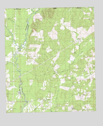
Chipola, LA USGS Topographic Map
Click on map above to begin viewing in our Map Viewer.

This topographic map contains these locations and features:
Feature Name Type Latitude Longitude GNIS ID View Map
Beaver CreekStreamN30.9518°W90.8547°553556View Map
Black Creek ChurchChurchN30.8771°W90.7690°560210View Map
Buck CreekStreamN30.8893°W90.8462°560291View Map
Channey CreekStreamN30.9449°W90.7715°560400View Map
ChipolaPopulated PlaceN30.9221°W90.8032°560425View Map
Clear CreekStreamN30.9191°W90.8559°560440View Map
Coleman TownPopulated PlaceN30.8893°W90.8201°1627943View Map
Collins CreekStreamN30.8824°W90.8570°554050View Map
DarlingtonPopulated PlaceN30.8780°W90.7815°560584View Map
Dry BranchStreamN30.9355°W90.8709°534601View Map
East Fork Amite RiverStreamN30.9938°W90.8351°560687View Map
Hurst CemeteryCemeteryN30.9836°W90.7935°1627313View Map
Joiner CreekStreamN30.9068°W90.8007°1627373View Map
Kemp CemeteryCemeteryN30.9457°W90.7770°1627393View Map
Little RiverStreamN30.8960°W90.8498°1627537View Map
McAdam BridgeBridgeN30.9455°W90.8595°550131View Map
Mitchell ChurchChurchN30.9266°W90.7754°1627675View Map
Parish Governing Authority District 1CivilN30.9253°W90.7582°1929755View Map
Riverside ChurchChurchN30.9871°W90.8684°538626View Map
Saint Helena ChurchChurchN30.9624°W90.7723°1628112View Map
Saint Marys BranchStreamN30.9746°W90.8520°538979View Map
Sandy RunStreamN30.8849°W90.8020°1628174View Map
South Sandy RunStreamN30.8974°W90.7679°1628261View Map
Spring BranchStreamN30.9666°W90.8462°678076View Map
Spring BranchStreamN30.8802°W90.8537°539575View Map
Thompson BridgeBridgeN30.8882°W90.8473°550145View Map
Turkey CreekStreamN30.9252°W90.8570°1628391View Map
Wales CemeteryCemeteryN30.9237°W90.7662°1628437View Map
West Fork Amite RiverStreamN30.9938°W90.8351°1628469View Map
Woodland CreekStreamN30.9502°W90.8543°1628527View Map

Note: Coordinates in the location and feature list above are referenced to NAD83 datum.


Copyright (C) 2008-2025 Ryan Niemi / Sunset Dynamics ... All Rights Reserved