TopoQuest Logo
Do you find TopoQuest useful?
Help keep TopoQuest running and adding new maps/features by donating!
Bitcoin:  19c7KJd3qBynnjoSw5npx9KScwjBe4ifkT
Litecoin:  LXs6TkuXGGXo1vDsWCkWVdjQX94eUKd6ui
Home View Maps Find Maps Find Places Resources & Links


Fiftysix, Arkansas Topographic Map

USGS Map Title: Fiftysix, AR
USGS Map MRC: 35092H2
DRG (GeoTIFF) Download: o35092h2.tif


Neighboring USGS Topographic Map Quads:


  Norfork SE, AR  
36092A3
 

  Calico Rock, AR  
36092A2
 

  Boswell, AR  
36092A1
 

  Onia, AR  
35092H3
 

  Fiftysix, AR  
35092H2
 

  Sylamore, AR  
35092H1
 

  Fox, AR  
35092G3
 

  Mountain View SW, AR  
35092G2
 

  Mountain View, AR  
35092G1


Map MRC Location:

N36°
W93°
N36°
W92°
H8 H7 H6 H5 H4 H3 H2 H1
G8 G7 G6 G5 G4 G3 G2 G1
F8 F7 F6 F5 F4 F3 F2 F1
E8 E7 E6 E5 E4 E3 E2 E1
D8 D7 D6 D5 D4 D3 D2 D1
C8 C7 C6 C5 C4 C3 C2 C1
B8 B7 B6 B5 B4 B3 B2 B1
A8 A7 A6 A5 A4 A3 A2 A1
N35°
W93°
N35°
W92°

Fiftysix, AR USGS 1:24K Topographic Map Preview:
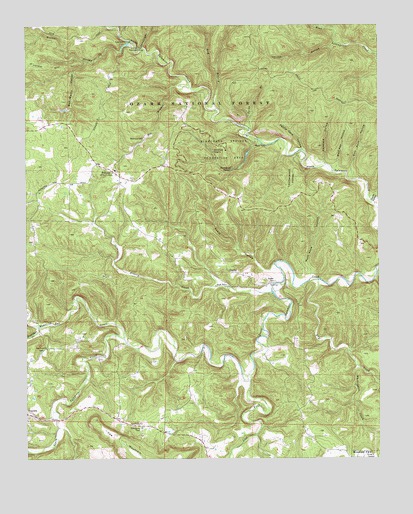
Fiftysix, AR USGS Topographic Map
Click on map above to begin viewing in our Map Viewer.

This topographic map contains these locations and features:
Feature Name Type Latitude Longitude GNIS ID View Map
Bad BranchStreamN35.9756°W92.1818°70485View Map
Bee BranchStreamN35.9823°W92.1915°70599View Map
Blanchard SpringSpringN35.9585°W92.1774°70713View Map
Blanchard Springs DamDamN35.9651°W92.1702°80160View Map
Blanchard Springs Recreation AreaParkN35.9640°W92.1793°70714View Map
Buck Pond HollowValleyN35.9279°W92.1488°70898View Map
Bud Wallis HollowValleyN35.9898°W92.2293°70907View Map
City of Fifty-SixCivilN35.9618°W92.2299°2403608View Map
Cornfield HollowValleyN35.9601°W92.1443°71233View Map
Dry CreekStreamN35.9267°W92.1463°71445View Map
Fifty - Six Volunteer Fire Department Main StationBuildingN35.9549°W92.2179°2116428View Map
Fifty - Six Volunteer Fire Department SubstationBuildingN35.9547°W92.2210°2116429View Map
FiftysixPopulated PlaceN35.9576°W92.2185°71610View Map
Fiftysix Work CenterLocaleN35.9637°W92.2277°74568View Map
GaylerPopulated PlaceN35.9273°W92.1702°71741View Map
Gayler CemeteryCemeteryN35.9259°W92.1626°71742View Map
Grassy CreekStreamN35.9231°W92.1627°71811View Map
Gunner CreekStreamN35.9951°W92.2135°71862View Map
Gunner HollowValleyN35.9951°W92.2135°71863View Map
Gunner Pool LakeReservoirN35.9943°W92.2148°79610View Map
Gunner Pool Lake DamDamN35.9951°W92.2135°79609View Map
Gunner Pool Recreation AreaParkN35.9923°W92.2110°71864View Map
Hedges (historical)Populated PlaceN35.9737°W92.2215°65830View Map
Herald HollowValleyN35.9948°W92.1404°71971View Map
Herdman HollowValleyN35.9270°W92.1263°71975View Map
Jacks BranchStreamN35.9701°W92.1710°72162View Map
Leatherwood HollowValleyN35.9615°W92.1599°72298View Map
Lick ForkStreamN35.8990°W92.1713°72341View Map
Mirror LakeReservoirN35.9651°W92.1702°80161View Map
North Sylamore CampgroundLocaleN35.9720°W92.1782°74569View Map
Oak Grove ChurchChurchN35.9067°W92.2429°72912View Map
Panther CreekStreamN35.9131°W92.2463°72987View Map
Partee SpringSpringN35.9915°W92.1279°74565View Map
Petrie Cave HollowValleyN35.9642°W92.1521°73057View Map
Red Doors CemeteryCemeteryN35.8834°W92.2099°73252View Map
Red Doors ChurchChurchN35.8851°W92.2093°73253View Map
Roasting Ear CreekStreamN35.9095°W92.2157°78186View Map
Rough HollowValleyN35.9990°W92.1396°73395View Map
Sandstone CreekStreamN35.9934°W92.2088°73479View Map
Shady Grove ChurchChurchN35.9245°W92.1788°73520View Map
Shelter Cave Picnic AreaLocaleN35.9690°W92.1729°74570View Map
Sick Rock HollowValleyN35.9554°W92.1340°73575View Map
Stone Drive-InLocaleN35.8764°W92.1306°2634150View Map
Township of HarrisCivilN35.9294°W92.1326°69724View Map
Township of NorthwestCivilN35.9975°W92.2350°69730View Map
Tri-County Elementary SchoolSchoolN35.9584°W92.2185°65847View Map
Trotter HollowValleyN35.9492°W92.1271°73896View Map
Tubbs CreekStreamN35.8817°W92.1688°73897View Map
Whitewater CreekStreamN35.9017°W92.1327°74135View Map
Wolf Pen HollowValleyN35.9579°W92.1407°74195View Map

Note: Coordinates in the location and feature list above are referenced to NAD83 datum.


Copyright (C) 2008-2025 Ryan Niemi / Sunset Dynamics ... All Rights Reserved