TopoQuest Logo
Do you find TopoQuest useful?
Help keep TopoQuest running and adding new maps/features by donating!
Bitcoin:  19c7KJd3qBynnjoSw5npx9KScwjBe4ifkT
Litecoin:  LXs6TkuXGGXo1vDsWCkWVdjQX94eUKd6ui
Home View Maps Find Maps Find Places Resources & Links


Sylamore, Arkansas Topographic Map

USGS Map Title: Sylamore, AR
USGS Map MRC: 35092H1
DRG (GeoTIFF) Download: o35092h1.tif


Neighboring USGS Topographic Map Quads:


  Calico Rock, AR  
36092A2
 

  Boswell, AR  
36092A1
 

  Melbourne, AR  
36091A8
 

  Fiftysix, AR  
35092H2
 

  Sylamore, AR  
35092H1
 

  Guion, AR  
35091H8
 

  Mountain View SW, AR  
35092G2
 

  Mountain View, AR  
35092G1
 

  Marcella, AR  
35091G8


Map MRC Location:

N36°
W93°
N36°
W92°
H8 H7 H6 H5 H4 H3 H2 H1
G8 G7 G6 G5 G4 G3 G2 G1
F8 F7 F6 F5 F4 F3 F2 F1
E8 E7 E6 E5 E4 E3 E2 E1
D8 D7 D6 D5 D4 D3 D2 D1
C8 C7 C6 C5 C4 C3 C2 C1
B8 B7 B6 B5 B4 B3 B2 B1
A8 A7 A6 A5 A4 A3 A2 A1
N35°
W93°
N35°
W92°

Sylamore, AR USGS 1:24K Topographic Map Preview:
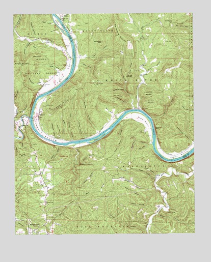
Sylamore, AR USGS Topographic Map
Click on map above to begin viewing in our Map Viewer.

This topographic map contains these locations and features:
Feature Name Type Latitude Longitude GNIS ID View Map
AllisonPopulated PlaceN35.9367°W92.1174°70432View Map
Allison - Sylamore Volunteer Fire Station 1BuildingN35.9547°W92.1071°2116065View Map
Allison - Sylamore Volunteer Fire Station 2BuildingN35.9027°W92.1070°2116066View Map
Allison - Sylamore Volunteer Fire Station 3BuildingN35.9443°W92.1073°2116067View Map
Allison - Sylamore Volunteer Fire Station 4BuildingN35.9194°W92.0528°2116068View Map
Arkins (historical)Populated PlaceN35.9848°W92.0829°65851View Map
Assembly of God ChurchChurchN35.8929°W92.1038°65823View Map
Bailey HollowValleyN35.9281°W92.0927°70488View Map
Bald ScrappySummitN35.9679°W92.1118°70497View Map
Barn HollowValleyN35.8959°W92.0815°70513View Map
Bear Spring GapGapN35.9948°W92.0143°70575View Map
Beckman CemeteryCemeteryN35.9306°W92.0329°70595View Map
Beckman HollowValleyN35.9256°W92.0290°70596View Map
Ben West MountainSummitN35.9498°W92.0293°70625View Map
Bishop HollowValleyN35.9317°W92.0660°70690View Map
BrandenburgPopulated PlaceN35.9862°W92.0368°65860View Map
Brandenburg MountainSummitN35.9848°W92.0460°70796View Map
Bright HollowValleyN35.8862°W92.0265°70823View Map
Brown HollowValleyN35.8967°W92.0313°70843View Map
Buck IslandIslandN35.9298°W92.0657°70891View Map
Candlestick KnobSummitN35.9840°W92.0638°70981View Map
Canning Kitchen HollowValleyN35.9542°W92.1018°71003View Map
Cave HollowValleyN35.9059°W92.0263°71043View Map
Cedar ScrappySummitN35.9762°W92.1121°71096View Map
Chisholm HollowValleyN35.9865°W92.1099°71144View Map
Church of ChristChurchN35.9867°W92.0357°65868View Map
Church of ChristChurchN35.9865°W92.0357°74556View Map
Cold Springs HollowValleyN35.9279°W92.0852°71188View Map
Condrey HollowValleyN35.9012°W92.0246°71209View Map
Cove HollowValleyN35.9401°W92.0529°71250View Map
Dark HollowValleyN35.9606°W92.0471°71336View Map
Davis HollowValleyN35.8940°W92.0829°71345View Map
Dry CreekStreamN35.9406°W92.0302°71433View Map
East Livingston CreekStreamN35.9912°W92.1243°71517View Map
East Twin CreekStreamN35.9456°W92.0379°71524View Map
Falls HollowValleyN35.9254°W92.0329°71588View Map
Farber CemeteryCemeteryN35.9751°W92.0299°71593View Map
Gann HollowValleyN35.9706°W92.0824°71717View Map
Glady HollowValleyN35.9151°W92.0815°71764View Map
Graveyard HollowValleyN35.9276°W92.0965°71822View Map
Greasy BottomBendN35.9190°W92.0102°71825View Map
Gulley CemeteryCemeteryN35.9840°W92.0193°71853View Map
Handford BluffCliffN35.9351°W92.0271°71896View Map
Haney HollowValleyN35.9609°W92.0927°71898View Map
Harper HollowValleyN35.8773°W92.0338°71913View Map
Harris BottomBendN35.9659°W92.0879°71915View Map
Harris CemeteryCemeteryN35.9601°W92.1040°71918View Map
Hell CreekStreamN35.9265°W92.0827°71958View Map
HerpelPopulated PlaceN35.9076°W92.0268°71976View Map
Isaac West MountainSummitN35.9545°W92.0315°72153View Map
Jeffrey CemeteryCemeteryN35.9820°W92.0863°72174View Map
Johnson HollowValleyN35.9848°W92.1138°72207View Map
Landers IslandIslandN35.9937°W92.0935°72285View Map
Lawson HollowValleyN35.9026°W92.0838°72291View Map
Levisy FlatFlatN35.9073°W92.1096°72309View Map
Levisy Flat CemeteryCemeteryN35.9051°W92.1024°72310View Map
Livingston CreekStreamN35.9748°W92.0840°72429View Map
Livingston Creek CemeteryCemeteryN35.9845°W92.0979°72430View Map
Lower Twin Creek CemeteryCemeteryN35.9648°W92.0379°72515View Map
Nesbitt SpringSpringN35.8875°W92.0193°72849View Map
North Sylamore CreekStreamN35.9415°W92.1202°72897View Map
Old House HollowValleyN35.9917°W92.0929°72931View Map
Ozark Folk CenterBuildingN35.8809°W92.1177°65840View Map
Pelham CreekStreamN35.9959°W92.0918°73038View Map
Perrins Ferry (historical)CrossingN35.9765°W92.0829°65900View Map
Polk Mountain CemeteryCemeteryN35.9603°W92.0682°73154View Map
Rattlesnake HollowValleyN35.9565°W92.0479°73243View Map
Reed HollowValleyN35.9956°W92.0971°73268View Map
Ripley HollowValleyN35.9276°W92.0868°73303View Map
Roper HollowValleyN35.9440°W92.1224°73374View Map
Round BottomBendN35.9420°W92.0365°73400View Map
Round Bottom HollowValleyN35.9390°W92.0513°73401View Map
Ruddells (historical)Populated PlaceN35.9287°W92.0918°65910View Map
Ruddells CemeteryCemeteryN35.9301°W92.0982°73433View Map
Sand HollowValleyN35.9667°W92.0332°73472View Map
Scrappy MountainSummitN35.9726°W92.1213°73504View Map
Sheep HollowValleyN35.9287°W92.0757°73530View Map
Sir Alec GapGapN35.9681°W92.0427°73590View Map
Sir Alec MountainSummitN35.9648°W92.0424°73591View Map
South Sylamore CreekStreamN35.9404°W92.1140°73655View Map
Squirrel HollowValleyN35.9492°W92.0435°73681View Map
Sweat HollowValleyN35.9315°W92.0452°73794View Map
SylamorePopulated PlaceN35.9415°W92.1082°73810View Map
Sylamore Baptist ChurchChurchN35.9437°W92.1077°65917View Map
Sylamore BottomBendN35.9315°W92.1054°73811View Map
Sylamore CemeteryCemeteryN35.9478°W92.1032°73812View Map
Sylamore Ranger District OfficeBuildingN35.8762°W92.1018°74557View Map
Township of WashingtonCivilN35.9084°W92.0350°69741View Map
Township of White RiverCivilN35.9566°W92.0501°66716View Map
Twin CreekPopulated PlaceN35.9456°W92.0363°73922View Map
Upper Twin Creek CemeteryCemeteryN35.9851°W92.0343°73950View Map
Wade HollowValleyN35.9059°W92.0263°73975View Map
Walker HollowValleyN35.9290°W92.1199°73988View Map
Warren BranchStreamN35.9148°W92.0815°74008View Map
Warren HollowValleyN35.9254°W92.0938°74009View Map
West Livingston CreekStreamN35.9909°W92.1243°74076View Map
West Twin CreekStreamN35.9456°W92.0410°74087View Map
White River Airport (historical)AirportN35.9209°W92.0057°83779View Map
Whitehouse HollowValleyN35.9542°W92.1077°74131View Map
Wildcat HollowValleyN35.9720°W92.0796°74150View Map
Wolf MountainSummitN35.9537°W92.0507°74192View Map
Woody HollowValleyN35.8934°W92.0332°74212View Map

Note: Coordinates in the location and feature list above are referenced to NAD83 datum.


Copyright (C) 2008-2024 Ryan Niemi / Sunset Dynamics ... All Rights Reserved