TopoQuest Logo
Do you find TopoQuest useful?
Help keep TopoQuest running and adding new maps/features by donating!
Bitcoin:  19c7KJd3qBynnjoSw5npx9KScwjBe4ifkT
Litecoin:  LXs6TkuXGGXo1vDsWCkWVdjQX94eUKd6ui
Home View Maps Find Maps Find Places Resources & Links


Mountain View SW, Arkansas Topographic Map

USGS Map Title: Mountain View SW, AR
USGS Map MRC: 35092G2
DRG (GeoTIFF) Download: o35092g2.tif


Neighboring USGS Topographic Map Quads:


  Onia, AR  
35092H3
 

  Fiftysix, AR  
35092H2
 

  Sylamore, AR  
35092H1
 

  Fox, AR  
35092G3
 

  Mountain View SW, AR  
35092G2
 

  Mountain View, AR  
35092G1
 

  Shirley, AR  
35092F3
 

  Parma, AR  
35092F2
 

  Prim, AR  
35092F1


Map MRC Location:

N36°
W93°
N36°
W92°
H8 H7 H6 H5 H4 H3 H2 H1
G8 G7 G6 G5 G4 G3 G2 G1
F8 F7 F6 F5 F4 F3 F2 F1
E8 E7 E6 E5 E4 E3 E2 E1
D8 D7 D6 D5 D4 D3 D2 D1
C8 C7 C6 C5 C4 C3 C2 C1
B8 B7 B6 B5 B4 B3 B2 B1
A8 A7 A6 A5 A4 A3 A2 A1
N35°
W93°
N35°
W92°

Mountain View SW, AR USGS 1:24K Topographic Map Preview:
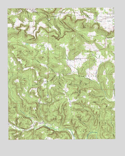
Mountain View SW, AR USGS Topographic Map
Click on map above to begin viewing in our Map Viewer.

This topographic map contains these locations and features:
Feature Name Type Latitude Longitude GNIS ID View Map
Ashlock HillSummitN35.8020°W92.1602°57283View Map
Bancroft HillSummitN35.7562°W92.2474°46067View Map
Bean CreekStreamN35.8140°W92.1682°46189View Map
Benton HollowValleyN35.8092°W92.1610°46396View Map
Berry HollowValleyN35.7709°W92.2254°46412View Map
Black BranchStreamN35.8609°W92.1443°46663View Map
Brown Camp HollowValleyN35.8006°W92.2254°46987View Map
Brushy CreekStreamN35.7631°W92.2068°47064View Map
Bull Pen HollowValleyN35.8667°W92.1946°47172View Map
Caney HollowValleyN35.8334°W92.1807°47436View Map
Cantrel RidgeRidgeN35.8712°W92.2368°47454View Map
Carr HollowValleyN35.8645°W92.2038°47480View Map
Cave HollowValleyN35.7606°W92.2421°47543View Map
Cave Spring BranchStreamN35.8267°W92.1427°47553View Map
Cave Spring HollowValleyN35.7579°W92.1896°55208View Map
Coal HollowValleyN35.7565°W92.1513°47869View Map
Collins HillSummitN35.8342°W92.1679°57573View Map
Cow MountainSummitN35.8745°W92.1979°71262View Map
Dodd Mountain Fire Department Station 3BuildingN35.8453°W92.1352°2116365View Map
Dug Hill HollowValleyN35.7829°W92.2135°48682View Map
Dunham HollowValleyN35.7598°W92.1915°48707View Map
East RichwoodsPopulated PlaceN35.8459°W92.1346°48775View Map
Elizabeth ChurchChurchN35.8392°W92.2113°48850View Map
Fife HillSummitN35.7731°W92.2168°49041View Map
Finch CemeteryCemeteryN35.7642°W92.1988°49046View Map
Finch MountainSummitN35.8020°W92.1985°49049View Map
Fredonia CemeteryCemeteryN35.8251°W92.1504°49227View Map
Fredonia HillSummitN35.8223°W92.1560°49228View Map
Gardner HollowValleyN35.7909°W92.1354°49340View Map
Glen HillSummitN35.7967°W92.2385°49439View Map
Goodson BranchStreamN35.7637°W92.2490°49501View Map
Goodson HollowValleyN35.7637°W92.2490°49502View Map
Green HollowValleyN35.8520°W92.2202°49642View Map
Hairpin HollowValleyN35.7601°W92.2327°49758View Map
Halapane RidgeRidgeN35.8056°W92.1338°49759View Map
Hawkins HillSummitN35.7806°W92.2449°57900View Map
Hughes CreekStreamN35.8748°W92.1629°50399View Map
Indian KnobSummitN35.8731°W92.1399°57968View Map
Johnson CreekStreamN35.7854°W92.1254°50695View Map
Keilhorn RidgeRidgeN35.7612°W92.1365°50787View Map
Lick ForkStreamN35.7609°W92.2193°51151View Map
Lick HollowValleyN35.7559°W92.1463°51154View Map
Long Branch HollowValleyN35.7501°W92.1263°51416View Map
Looney HollowValleyN35.8731°W92.2304°51454View Map
Lost MountainSummitN35.8062°W92.2385°51476View Map
McGee HollowValleyN35.8015°W92.1660°51837View Map
Mennonite ChurchChurchN35.8623°W92.2218°65835View Map
Murphy HollowValleyN35.8679°W92.1904°52554View Map
Murphy RidgeRidgeN35.8581°W92.1771°52557View Map
Pelahan HollowValleyN35.8137°W92.1902°53262View Map
Price HollowValleyN35.8637°W92.2024°53795View Map
Sams CreekStreamN35.8026°W92.1429°78289View Map
Shannon HollowValleyN35.8731°W92.2304°54729View Map
Shaw HollowValleyN35.7845°W92.2140°54746View Map
Squirrel HollowValleyN35.8406°W92.1518°55141View Map
Stone CountyCivilN35.8599°W92.1567°69902View Map
Stone County Sheriff's OfficeBuildingN35.8690°W92.1297°2118839View Map
Sugar HillSummitN35.8281°W92.2110°58705View Map
Sunny LandLocaleN35.8056°W92.2085°55337View Map
Sunnyland Volunteer Fire Department Station 1BuildingN35.8044°W92.2084°2117192View Map
Sunnyland Volunteer Fire Department Station 2BuildingN35.8376°W92.2084°2117193View Map
Taylor RidgeRidgeN35.7734°W92.1996°55477View Map
Timbo Fire and Rescue Happy HollowBuildingN35.8625°W92.2234°2119173View Map
Township of LibertyCivilN35.8340°W92.2284°69728View Map
Township of RichwoodsCivilN35.8094°W92.1506°69733View Map
Township of Turkey CreekCivilN35.7508°W92.2443°69738View Map
Turkey CreekPopulated PlaceN35.7665°W92.2099°55710View Map
Vivian HollowValleyN35.8134°W92.1927°55927View Map
Wade HillSummitN35.7809°W92.1365°58808View Map
Wade HollowValleyN35.7904°W92.1352°55934View Map
West RichwoodsPopulated PlaceN35.8265°W92.1718°78728View Map
West Richwoods ChurchChurchN35.8265°W92.1724°65849View Map
West Richwoods School (historical)SchoolN35.8265°W92.1724°65850View Map
Wildcat HollowValleyN35.7623°W92.1538°56364View Map

Note: Coordinates in the location and feature list above are referenced to NAD83 datum.


Copyright (C) 2008-2024 Ryan Niemi / Sunset Dynamics ... All Rights Reserved