TopoQuest Logo
Do you find TopoQuest useful?
Help keep TopoQuest running and adding new maps/features by donating!
Bitcoin:  19c7KJd3qBynnjoSw5npx9KScwjBe4ifkT
Litecoin:  LXs6TkuXGGXo1vDsWCkWVdjQX94eUKd6ui
Home View Maps Find Maps Find Places Resources & Links


Fitzgerald West, Georgia Topographic Map

USGS Map Title: Fitzgerald West, GA
USGS Map MRC: 31083F3
DRG (GeoTIFF) Download: o31083f3.tif


Neighboring USGS Topographic Map Quads:


  Rebecca, GA  
31083G4
 

  Sibbie, GA  
31083G3
 

  Queensland, GA  
31083G2
 

  Irwinville, GA  
31083F4
 

  Fitzgerald West, GA  
31083F3
 

  Fitzgerald East, GA  
31083F2
 

  Waterloo, GA  
31083E4
 

  Ocilla West, GA  
31083E3
 

  Ocilla East, GA  
31083E2


Map MRC Location:

N32°
W84°
N32°
W83°
H8 H7 H6 H5 H4 H3 H2 H1
G8 G7 G6 G5 G4 G3 G2 G1
F8 F7 F6 F5 F4 F3 F2 F1
E8 E7 E6 E5 E4 E3 E2 E1
D8 D7 D6 D5 D4 D3 D2 D1
C8 C7 C6 C5 C4 C3 C2 C1
B8 B7 B6 B5 B4 B3 B2 B1
A8 A7 A6 A5 A4 A3 A2 A1
N31°
W84°
N31°
W83°

Fitzgerald West, GA USGS 1:24K Topographic Map Preview:
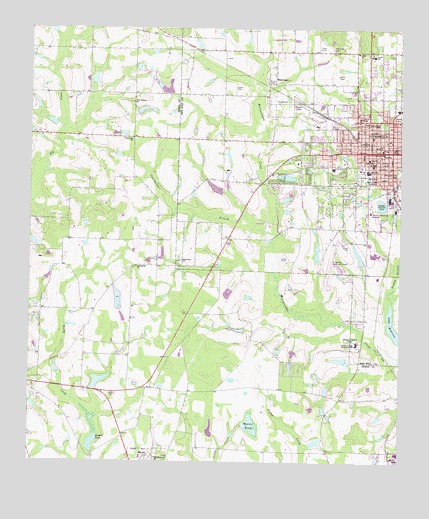
Fitzgerald West, GA USGS Topographic Map
Click on map above to begin viewing in our Map Viewer.

This topographic map contains these locations and features:
Feature Name Type Latitude Longitude GNIS ID View Map
American Legion ParkParkN31.7230°W83.2560°310511View Map
Arbor CemeteryCemeteryN31.7443°W83.2774°310598View Map
Arbor ChurchChurchN31.7432°W83.2643°354384View Map
Ben Hill County Elementary SchoolSchoolN31.7424°W83.2596°335353View Map
Ben Hill County Emergency Medical ServicesBuildingN31.7182°W83.2575°2625437View Map
Ben Hill County HospitalHospitalN31.7124°W83.2607°335354View Map
Ben Hill County JailBuildingN31.6957°W83.2570°335355View Map
Ben Hill County Sheriff's DepartmentBuildingN31.6957°W83.2570°2734226View Map
Ben Hill County Volunteer Fire Department Station 3BuildingN31.7225°W83.2571°2603898View Map
Ben Hill DamDamN31.6835°W83.2665°335950View Map
Ben Hill-Irwin Vocational SchoolSchoolN31.6594°W83.2643°354546View Map
Blue and Gray ParkParkN31.7094°W83.2507°311539View Map
Bussell PondReservoirN31.6298°W83.3544°312088View Map
Bussells Pond DamDamN31.6282°W83.3546°337277View Map
Central Christian ChurchChurchN31.7116°W83.2554°335360View Map
Central Methodist ChurchChurchN31.7149°W83.2563°335361View Map
Church of the NazareneChurchN31.7180°W83.2538°335363View Map
City of FitzgeraldCivilN31.7135°W83.2516°2403612View Map
County LakeReservoirN31.6848°W83.2639°340821View Map
County Lake DamDamN31.6835°W83.2632°340820View Map
Courthouse BranchStreamN31.6902°W83.2907°313043View Map
Dixon CemeteryCemeteryN31.7330°W83.3052°313499View Map
Dorminy Medical CenterHospitalN31.6975°W83.2602°313550View Map
Englewood CemeteryCemeteryN31.6832°W83.3240°335369View Map
Englewood ChurchChurchN31.6832°W83.3235°355695View Map
First Baptist ChurchChurchN31.7127°W83.2549°335373View Map
First Presbyterian ChurchChurchN31.7105°W83.2532°335374View Map
FitzgeraldPopulated PlaceN31.7149°W83.2527°355809View Map
Fitzgerald City HallBuildingN31.7149°W83.2513°335375View Map
Fitzgerald Elementary SchoolSchoolN31.7188°W83.2596°335376View Map
Fitzgerald Fire DepartmentBuildingN31.7132°W83.2506°2603595View Map
Fitzgerald Fire Department Station 2BuildingN31.7182°W83.2575°2604302View Map
Fitzgerald High SchoolSchoolN31.7091°W83.2610°335377View Map
Fitzgerald Junior High SchoolSchoolN31.7107°W83.2593°335378View Map
Fitzgerald Municipal AirportAirportN31.6819°W83.2710°351767View Map
Fitzgerald Plaza Shopping CenterLocaleN31.7271°W83.2510°335380View Map
Fitzgerald Police DepartmentBuildingN31.6957°W83.2570°2733800View Map
Fitzgerald Post OfficePost OfficeN31.7155°W83.2546°352088View Map
Fitzgerald West LakeReservoirN31.6996°W83.2565°341922View Map
Fitzgerald West Lake DamDamN31.7002°W83.2565°341921View Map
Fitzgerald-Ben Hill County LibraryBuildingN31.7138°W83.2554°335381View Map
Friendship CemeteryCemeteryN31.7182°W83.3399°344958View Map
Friendship ChurchChurchN31.7182°W83.3399°314403View Map
Hills Midtown Mall Shopping CenterLocaleN31.7077°W83.2521°335386View Map
Hogan LakeReservoirN31.6484°W83.3514°341800View Map
Hogan Lake DamDamN31.6469°W83.3532°341799View Map
Mann Shopping CenterLocaleN31.7155°W83.2554°335392View Map
New Prospect ChurchChurchN31.7288°W83.3402°319502View Map
Old Diz Mucke PondReservoirN31.6310°W83.2778°342038View Map
Old Diz Mucke Pond DamDamN31.6302°W83.2799°342037View Map
Pine Blossom ChurchChurchN31.6263°W83.3318°320537View Map
Roanoke School (historical)SchoolN31.7057°W83.2738°335403View Map
Saint Mathews Episcopal ChurchChurchN31.7132°W83.2565°335404View Map
Saint Peters ChurchChurchN31.7235°W83.2640°322295View Map
Saint Williams Catholic Church (historical)ChurchN31.7149°W83.2568°335405View Map
Simms LakeReservoirN31.7073°W83.2877°341924View Map
Simms Lake DamDamN31.7069°W83.2882°341923View Map
Springfield ChurchChurchN31.6816°W83.3388°323461View Map
Stewart LakeReservoirN31.6549°W83.2696°337306View Map
Stewart Lake DamDamN31.6535°W83.2682°337305View Map
Taylor LakeReservoirN31.7197°W83.3437°342040View Map
Taylor Lake DamDamN31.7202°W83.3449°342039View Map
Turkey CreekStreamN31.6713°W83.2527°310362View Map
Union Holiness Church (historical)ChurchN31.7088°W83.2627°335413View Map
Village Shopping CenterLocaleN31.7005°W83.2507°335416View Map
Walker LakeReservoirN31.7352°W83.3532°342042View Map
Walker Lake DamDamN31.7335°W83.3532°342041View Map
Walters LakeReservoirN31.6530°W83.2866°342044View Map
Walters Lake DamDamN31.6552°W83.2882°342043View Map
WBHB-AM (Fitzgerald)TowerN31.7066°W83.2610°352443View Map
Weaver PondReservoirN31.6359°W83.2998°324951View Map
Weaver Pond DamDamN31.6357°W83.3002°342035View Map
Westside ChurchChurchN31.7180°W83.2618°325097View Map
WestwoodPopulated PlaceN31.7349°W83.2924°333400View Map
Westwood CemeteryCemeteryN31.7441°W83.2732°325109View Map
Westwood ChurchChurchN31.7357°W83.2952°335418View Map
Zion Rest Primitive Baptist ChurchChurchN31.7174°W83.2593°335423View Map

Note: Coordinates in the location and feature list above are referenced to NAD83 datum.


Copyright (C) 2008-2025 Ryan Niemi / Sunset Dynamics ... All Rights Reserved