TopoQuest Logo
Do you find TopoQuest useful?
Help keep TopoQuest running and adding new maps/features by donating!
Bitcoin:  19c7KJd3qBynnjoSw5npx9KScwjBe4ifkT
Litecoin:  LXs6TkuXGGXo1vDsWCkWVdjQX94eUKd6ui
Home View Maps Find Maps Find Places Resources & Links


Fitzgerald East, Georgia Topographic Map

USGS Map Title: Fitzgerald East, GA
USGS Map MRC: 31083F2
DRG (GeoTIFF) Download: o31083f2.tif


Neighboring USGS Topographic Map Quads:


  Sibbie, GA  
31083G3
 

  Queensland, GA  
31083G2
 

  China Hill, GA  
31083G1
 

  Fitzgerald West, GA  
31083F3
 

  Fitzgerald East, GA  
31083F2
 

  Osierfield, GA  
31083F1
 

  Ocilla West, GA  
31083E3
 

  Ocilla East, GA  
31083E2
 

  Ambrose, GA  
31083E1


Map MRC Location:

N32°
W84°
N32°
W83°
H8 H7 H6 H5 H4 H3 H2 H1
G8 G7 G6 G5 G4 G3 G2 G1
F8 F7 F6 F5 F4 F3 F2 F1
E8 E7 E6 E5 E4 E3 E2 E1
D8 D7 D6 D5 D4 D3 D2 D1
C8 C7 C6 C5 C4 C3 C2 C1
B8 B7 B6 B5 B4 B3 B2 B1
A8 A7 A6 A5 A4 A3 A2 A1
N31°
W84°
N31°
W83°

Fitzgerald East, GA USGS 1:24K Topographic Map Preview:
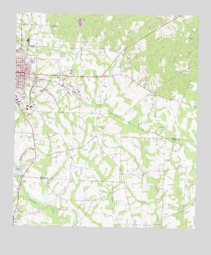
Fitzgerald East, GA USGS Topographic Map
Click on map above to begin viewing in our Map Viewer.

This topographic map contains these locations and features:
Feature Name Type Latitude Longitude GNIS ID View Map
Anderson Memorial ChurchChurchN31.7121°W83.2188°310527View Map
AshtonPopulated PlaceN31.7049°W83.1560°331058View Map
Ashton School (historical)SchoolN31.7035°W83.1560°335351View Map
Ben Hill County CourthouseBuildingN31.7144°W83.2496°335352View Map
Ben Hill County Volunteer Fire Department Station 1BuildingN31.7167°W83.1943°2604307View Map
Bethel African Methodist Episcopal ChurchChurchN31.7169°W83.2429°335357View Map
Callie Garbutt ChurchChurchN31.7302°W83.2407°1704658View Map
Church of GodChurchN31.7185°W83.2460°335362View Map
City of Fitzgerald Dam NortheastDamN31.7219°W83.2382°342322View Map
City of Fitzgerald Northeast PondReservoirN31.7213°W83.2388°342323View Map
Colony Square Shopping CenterLocaleN31.6938°W83.2457°335364View Map
Community ChurchChurchN31.7116°W83.2435°335365View Map
Davis LakeReservoirN31.6440°W83.2006°340855View Map
Davis Lake DamDamN31.6419°W83.1999°340854View Map
Dorminy LakeReservoirN31.7130°W83.1821°342325View Map
Dorminy Lake DamDamN31.7119°W83.1815°342324View Map
Eastside ChurchChurchN31.7141°W83.2188°313797View Map
Evergreen CemeteryCemeteryN31.7021°W83.2368°314003View Map
Ewing LakeReservoirN31.6399°W83.1776°337290View Map
Ewing Lake DamDamN31.6402°W83.1782°337289View Map
Fitzgerald City DamDamN31.7002°W83.2432°341917View Map
Fitzgerald City LakeReservoirN31.7002°W83.2438°341918View Map
Fitzgerald Country ClubLocaleN31.6896°W83.2410°344237View Map
Fitzgerald DivisionCivilN31.7344°W83.1537°1936266View Map
Fitzgerald High School (historical)SchoolN31.7091°W83.2432°335379View Map
Frank CemeteryCemeteryN31.6349°W83.2140°314345View Map
Frank ChurchChurchN31.6341°W83.2071°355905View Map
Ganoname661 DamDamN31.6352°W83.2282°337275View Map
Holiness ChurchChurchN31.7116°W83.2432°335387View Map
Holsee Chapel Christian Methodist Episcopal ChurchChurchN31.7169°W83.2424°335388View Map
Hopkins LakeReservoirN31.6454°W83.1294°337314View Map
Hopkins Lake DamDamN31.6435°W83.1299°337313View Map
Hunter School (historical)SchoolN31.7299°W83.2399°335389View Map
Kiokee CemeteryCemeteryN31.7418°W83.2263°335390View Map
Lake BeatriceReservoirN31.6567°W83.2470°341920View Map
Lake Beatrice DamDamN31.6594°W83.2479°341919View Map
Mc Cook CemeteryCemeteryN31.6702°W83.2018°317830View Map
Monitor Elementary School (historical)SchoolN31.7085°W83.2429°335394View Map
Moorehead DamDamN31.6752°W83.2415°335951View Map
Morehead LakeReservoirN31.6772°W83.2431°340823View Map
Morehead Lake DamDamN31.6769°W83.2449°340822View Map
Mount Calvary ChurchChurchN31.7366°W83.1290°318578View Map
Mount Olive Baptist ChurchChurchN31.7116°W83.2446°335395View Map
Mount Olive CemeteryCemeteryN31.6707°W83.2360°335396View Map
Mount Olive ChurchChurchN31.6699°W83.2354°318736View Map
New Mount Zion ChurchChurchN31.7421°W83.2263°319486View Map
New Providence Baptist ChurchChurchN31.7135°W83.2418°335398View Map
Old Field CemeteryCemeteryN31.7321°W83.1988°319977View Map
Pine Level ChurchChurchN31.6827°W83.1885°320627View Map
Pleasant Grove CemeteryCemeteryN31.6260°W83.1521°344990View Map
Pleasant Grove ChurchChurchN31.6263°W83.1527°320806View Map
Prospect CemeteryCemeteryN31.6838°W83.1474°335400View Map
Prospect ChurchChurchN31.6844°W83.1468°321161View Map
Salem Baptist ChurchChurchN31.7105°W83.2440°335406View Map
Second Ward School (historical)SchoolN31.7188°W83.2496°335408View Map
Shiloh ChurchChurchN31.7119°W83.2360°335409View Map
Shivers Lake Dam NorthDamN31.6269°W83.1599°340856View Map
Shivers Lake NorthReservoirN31.6287°W83.1603°340857View Map
Sturgeon ChurchChurchN31.7480°W83.1346°335410View Map
Sumner LakeReservoirN31.6420°W83.2273°342159View Map
Sumner Lake DamDamN31.6385°W83.2249°342158View Map
Third Ward School (historical)SchoolN31.7107°W83.2493°335412View Map
Troup CemeteryCemeteryN31.7191°W83.1768°324332View Map
Wesley Chapel Methodist Church (historical)ChurchN31.7310°W83.2407°335417View Map
WSIZ-AM (Ocilla)TowerN31.6285°W83.2479°352520View Map

Note: Coordinates in the location and feature list above are referenced to NAD83 datum.


Copyright (C) 2008-2024 Ryan Niemi / Sunset Dynamics ... All Rights Reserved