TopoQuest Logo
Do you find TopoQuest useful?
Help keep TopoQuest running and adding new maps/features by donating!
Bitcoin:  19c7KJd3qBynnjoSw5npx9KScwjBe4ifkT
Litecoin:  LXs6TkuXGGXo1vDsWCkWVdjQX94eUKd6ui
Home View Maps Find Maps Find Places Resources & Links


Ocilla East, Georgia Topographic Map

USGS Map Title: Ocilla East, GA
USGS Map MRC: 31083E2
DRG (GeoTIFF) Download: o31083e2.tif


Neighboring USGS Topographic Map Quads:


  Fitzgerald West, GA  
31083F3
 

  Fitzgerald East, GA  
31083F2
 

  Osierfield, GA  
31083F1
 

  Ocilla West, GA  
31083E3
 

  Ocilla East, GA  
31083E2
 

  Ambrose, GA  
31083E1
 

  Enigma, GA  
31083D3
 

  Alapaha, GA  
31083D2
 

  Lax, GA  
31083D1


Map MRC Location:

N32°
W84°
N32°
W83°
H8 H7 H6 H5 H4 H3 H2 H1
G8 G7 G6 G5 G4 G3 G2 G1
F8 F7 F6 F5 F4 F3 F2 F1
E8 E7 E6 E5 E4 E3 E2 E1
D8 D7 D6 D5 D4 D3 D2 D1
C8 C7 C6 C5 C4 C3 C2 C1
B8 B7 B6 B5 B4 B3 B2 B1
A8 A7 A6 A5 A4 A3 A2 A1
N31°
W84°
N31°
W83°

Ocilla East, GA USGS 1:24K Topographic Map Preview:
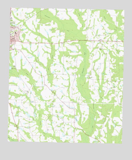
Ocilla East, GA USGS Topographic Map
Click on map above to begin viewing in our Map Viewer.

This topographic map contains these locations and features:
Feature Name Type Latitude Longitude GNIS ID View Map
Bethel ChurchChurchN31.6221°W83.2499°311166View Map
Broaches Chapel Christian Methodist Episcopal ChurchChurchN31.5994°W83.2449°344952View Map
Brushy CreekStreamN31.6010°W83.1777°311924View Map
Brushy Creek CemeteryCemeteryN31.5457°W83.2296°344953View Map
Brushy Creek ChurchChurchN31.5466°W83.2290°354885View Map
City of OcillaCivilN31.5986°W83.2498°2404417View Map
Cook LakeReservoirN31.5221°W83.1755°355277View Map
Cook Lake DamDamN31.5207°W83.1738°337279View Map
E Paulk LakeReservoirN31.5855°W83.1796°337326View Map
E Paulk Lake DamDamN31.5852°W83.1765°337325View Map
Freeman LakeReservoirN31.5802°W83.2432°340865View Map
Freeman Lake DamDamN31.5802°W83.2432°340864View Map
Harper LakeReservoirN31.5235°W83.2249°341810View Map
Harper LakeReservoirN31.5329°W83.1802°337304View Map
Harper Lake DamDamN31.5235°W83.2249°341809View Map
Harper Lake DamDamN31.5319°W83.1782°337303View Map
Henderson ChapelChurchN31.5885°W83.1510°315321View Map
Henderson Chapel CemeteryCemeteryN31.5891°W83.1510°344959View Map
HoltPopulated PlaceN31.5957°W83.1507°332014View Map
Holt Baptist ChurchChurchN31.5938°W83.1504°344960View Map
Holt CemeteryCemeteryN31.5938°W83.1510°344961View Map
Holt Volunteer Fire DepartmentBuildingN31.5828°W83.1433°2604574View Map
Irwin County Middle SchoolSchoolN31.6021°W83.2438°344968View Map
Mathis ChapelChurchN31.5696°W83.2446°317790View Map
Midway ChurchChurchN31.5969°W83.1513°318112View Map
Mount Olive African Methodist Episcopal ChurchChurchN31.5980°W83.2485°344974View Map
Ocilla Chapel Baptist Church (historical)ChurchN31.5977°W83.2454°344978View Map
Ocilla City CemeteryCemeteryN31.6013°W83.2454°344979View Map
Ocilla Fire DepartmentBuildingN31.5957°W83.2484°2603853View Map
Ocilla Police DepartmentBuildingN31.5909°W83.2496°2733601View Map
Ocilla-Holt Division (historical)CensusN31.5702°W83.2188°1936452View Map
Paulk CemeteryCemeteryN31.5613°W83.1607°320287View Map
Paulk CemeteryCemeteryN31.5210°W83.1896°344984View Map
Paulk CemeteryCemeteryN31.5999°W83.1654°344985View Map
Pine Hill ChurchChurchN31.6063°W83.2468°320595View Map
Pleasant Grove Baptist ChurchChurchN31.5980°W83.2479°344989View Map
Reedy CreekStreamN31.5002°W83.2390°321448View Map
Second Baptist ChurchChurchN31.5977°W83.2460°344995View Map
Shiver Lake Dam SouthDamN31.5802°W83.2182°337307View Map
Shiver Lake SouthReservoirN31.5821°W83.2177°337308View Map
Stump CreekStreamN31.5388°W83.2088°323709View Map
Tankersly LakeReservoirN31.5792°W83.2274°337302View Map
Tankersly Lake DamDamN31.5785°W83.2249°337301View Map
Third Baptist ChurchChurchN31.5994°W83.2429°344997View Map
Tucker Volunteer Fire DepartmentBuildingN31.5232°W83.1779°2604446View Map
Veal LakeReservoirN31.5675°W83.1877°340863View Map
Veal Lake DamDamN31.5652°W83.1849°340862View Map
Whitleys CemeteryCemeteryN31.6188°W83.1990°325234View Map
Willacoochee CreekStreamN31.6010°W83.1777°356641View Map
WSIZ-FM (Ocilla)TowerN31.5471°W83.1527°352749View Map

Note: Coordinates in the location and feature list above are referenced to NAD83 datum.


Copyright (C) 2008-2024 Ryan Niemi / Sunset Dynamics ... All Rights Reserved