TopoQuest Logo
Do you find TopoQuest useful?
Help keep TopoQuest running and adding new maps/features by donating!
Bitcoin:  19c7KJd3qBynnjoSw5npx9KScwjBe4ifkT
Litecoin:  LXs6TkuXGGXo1vDsWCkWVdjQX94eUKd6ui
Home View Maps Find Maps Find Places Resources & Links


Fivemile Creek, Oregon Topographic Map

USGS Map Title: Fivemile Creek, OR
USGS Map MRC: 43124G1
DRG (GeoTIFF) Download: o43124g1.tif


Neighboring USGS Topographic Map Quads:


  Goose Pasture, OR  
43124H2
 

  Florence, OR  
43124H1
 

  Goodwin Peak, OR  
43123H8
 

  Tahkenitch Creek, OR  
43124G2
 

  Fivemile Creek, OR  
43124G1
 

  North Fork, OR  
43123G8
 

  Winchester Bay, OR  
43124F2
 

  Reedsport, OR  
43124F1
 

  Deer Head Point, OR  
43123F8


Map MRC Location:

N44°
W125°
N44°
W124°
H8 H7 H6 H5 H4 H3 H2 H1
G8 G7 G6 G5 G4 G3 G2 G1
F8 F7 F6 F5 F4 F3 F2 F1
E8 E7 E6 E5 E4 E3 E2 E1
D8 D7 D6 D5 D4 D3 D2 D1
C8 C7 C6 C5 C4 C3 C2 C1
B8 B7 B6 B5 B4 B3 B2 B1
A8 A7 A6 A5 A4 A3 A2 A1
N43°
W125°
N43°
W124°

Fivemile Creek, OR USGS 1:24K Topographic Map Preview:
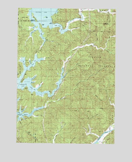
Fivemile Creek, OR USGS Topographic Map
Click on map above to begin viewing in our Map Viewer.

This topographic map contains these locations and features:
Feature Name Type Latitude Longitude GNIS ID View Map
Ada (historical)LocaleN43.8748°W124.0451°1137009View Map
Ada County ParkParkN43.8693°W124.0790°1153520View Map
Ada County Park Boat RampLocaleN43.8699°W124.0783°2668152View Map
Ada Post Office (historical)Post OfficeN43.8748°W124.0451°1164803View Map
Ada Resort Boat RampLocaleN43.8615°W124.0831°2668548View Map
Ada StationLocaleN43.8618°W124.0818°1137010View Map
Alder CreekStreamN43.8743°W124.0279°1137074View Map
Bass (historical)LocaleN43.8132°W124.1168°1137571View Map
Bear CreekStreamN43.8726°W124.0129°1137679View Map
Bear Trap ArmBayN43.8101°W124.1059°1639270View Map
Bedolf ArmBayN43.7721°W124.1248°1153417View Map
Bell CreekStreamN43.8385°W124.0143°1137898View Map
Big ArmBayN43.8235°W124.1193°1153423View Map
Black CreekStreamN43.7510°W124.0226°1153454View Map
Bombard BayBayN43.7732°W124.1193°1153416View Map
Booth (historical)LocaleN43.8487°W124.0884°1138443View Map
Booth ArmBayN43.8498°W124.0929°1153425View Map
Booth IslandIslandN43.8668°W124.1057°1138444View Map
Booth LandingLocaleN43.8290°W124.1012°1162228View Map
Booth Post Office (historical)Post OfficeN43.8487°W124.0884°1164940View Map
Booth RidgeRidgeN43.8507°W124.0151°1153435View Map
Brenham (historical)LocaleN43.7604°W124.1121°1138595View Map
Catfish HoleBayN43.8248°W124.1101°1162227View Map
Cherry ArmBayN43.7790°W124.1193°1153418View Map
Cherry PointCapeN43.7768°W124.1221°1153509View Map
Cleves CoveBayN43.7901°W124.1248°1153419View Map
Crabtree PointCapeN43.8068°W124.1087°1153517View Map
Dismal SwampSwampN43.8026°W124.0984°1153414View Map
Fiddle CreekStreamN43.8548°W124.0626°1142079View Map
Fiddle Creek Arm Siltcoos LakeBayN43.8593°W124.0734°1639271View Map
Fingerboard Slough CreekStreamN43.7632°W124.0026°1153453View Map
Fir Grove CemeteryCemeteryN43.8661°W124.0453°1142112View Map
Five Mile ArmBayN43.8012°W124.1068°1153421View Map
Fivemile CreekStreamN43.7976°W124.1021°1142204View Map
Frarey CreekStreamN43.7576°W124.0729°1639272View Map
Gardiner County Park Boat Ramp / DockLocaleN43.7705°W124.1237°2668630View Map
Gardiner LandingLocaleN43.7707°W124.1221°1162214View Map
H P Dutton Lumber Company (historical)LocaleN43.8401°W124.0943°1166287View Map
Halfway PointCapeN43.8048°W124.1096°1153516View Map
Harmony BayBayN43.8535°W124.1068°1153506View Map
Harry CreekStreamN43.8418°W124.0301°1143336View Map
Holden CreekStreamN43.7943°W124.0104°1639266View Map
Independent Order of Odd Fellows CemeteriesCemeteryN43.7837°W124.0957°1153434View Map
Isthmus PointCapeN43.8068°W124.1212°1153437View Map
John Sims CreekStreamN43.8282°W124.0923°1639263View Map
Joyce CreekStreamN43.7554°W124.0209°1144412View Map
King CreekStreamN43.8746°W124.0387°1639261View Map
Lane CreekStreamN43.8457°W124.0909°1144810View Map
Leitel CreekStreamN43.7757°W124.1082°1144929View Map
Lone Tree PointCapeN43.8026°W124.1137°1153513View Map
Mallard ArmBayN43.7757°W124.1226°1145772View Map
Mallard CreekStreamN43.7760°W124.1082°1145773View Map
Middle PointCapeN43.7798°W124.1207°1153436View Map
Miles CanyonValleyN43.8707°W124.0109°1639259View Map
North ArmBayN43.8221°W124.1082°1153424View Map
Patterson CreekStreamN43.8187°W124.0443°1153810View Map
Perkins CreekStreamN43.8104°W124.0690°1147595View Map
Pretty GulchValleyN43.7735°W124.0318°1639267View Map
Reed IslandIslandN43.8662°W124.0915°1148354View Map
Rocky PointCapeN43.8610°W124.0990°1153519View Map
Ruby Post Office (historical)Post OfficeN43.8123°W124.0679°1165893View Map
Silver CreekStreamN43.8551°W124.0621°1639262View Map
Siuslaw Valley Fire and Rescue Station 6 Ada StationBuildingN43.8747°W124.0432°2577101View Map
Snake PointCapeN43.7971°W124.0832°1639265View Map
Snare PointCapeN43.7971°W124.1054°1153511View Map
Spike ArmBayN43.8065°W124.1068°1639269View Map
Tahkenitch LakeLakeN43.7761°W124.1083°1150839View Map
The IsthmusIsthmusN43.8366°W124.0988°1639264View Map
Young CreekStreamN43.8740°W124.0434°1639260View Map

Note: Coordinates in the location and feature list above are referenced to NAD83 datum.


Copyright (C) 2008-2024 Ryan Niemi / Sunset Dynamics ... All Rights Reserved