TopoQuest Logo
Do you find TopoQuest useful?
Help keep TopoQuest running and adding new maps/features by donating!
Bitcoin:  19c7KJd3qBynnjoSw5npx9KScwjBe4ifkT
Litecoin:  LXs6TkuXGGXo1vDsWCkWVdjQX94eUKd6ui
Home View Maps Find Maps Find Places Resources & Links


Reedsport, Oregon Topographic Map

USGS Map Title: Reedsport, OR
USGS Map MRC: 43124F1
DRG (GeoTIFF) Download: o43124f1.tif


Neighboring USGS Topographic Map Quads:


  Tahkenitch Creek, OR  
43124G2
 

  Fivemile Creek, OR  
43124G1
 

  North Fork, OR  
43123G8
 

  Winchester Bay, OR  
43124F2
 

  Reedsport, OR  
43124F1
 

  Deer Head Point, OR  
43123F8
 

  Lakeside, OR  
43124E2
 

  Trail Butte, OR  
43124E1
 

  Elk Peak, OR  
43123E8


Map MRC Location:

N44°
W125°
N44°
W124°
H8 H7 H6 H5 H4 H3 H2 H1
G8 G7 G6 G5 G4 G3 G2 G1
F8 F7 F6 F5 F4 F3 F2 F1
E8 E7 E6 E5 E4 E3 E2 E1
D8 D7 D6 D5 D4 D3 D2 D1
C8 C7 C6 C5 C4 C3 C2 C1
B8 B7 B6 B5 B4 B3 B2 B1
A8 A7 A6 A5 A4 A3 A2 A1
N43°
W125°
N43°
W124°

Reedsport, OR USGS 1:24K Topographic Map Preview:
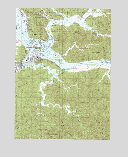
Reedsport, OR USGS Topographic Map
Click on map above to begin viewing in our Map Viewer.

This topographic map contains these locations and features:
Feature Name Type Latitude Longitude GNIS ID View Map
Alder CreekStreamN43.6454°W124.0426°1137062View Map
Beautiful Savior Lutheran ChurchChurchN43.6942°W124.1222°2508110View Map
Blacks IslandIslandN43.7132°W124.0843°1138236View Map
Bolon IslandIslandN43.7137°W124.0990°1138400View Map
Bolon Island State Park Boat RampLocaleN43.7127°W124.1049°2668447View Map
Bolon Island Tideways State Scenic CorridorParkN43.7123°W124.1023°1138401View Map
Brainard CreekStreamN43.7460°W124.0287°1138568View Map
Brandy Bar Landing Wastewater Treatment FacilityLocaleN43.7000°W124.1005°2660717View Map
Butler CreekStreamN43.7107°W124.0798°1139046View Map
Camp Seven GulchValleyN43.7415°W124.0568°1639273View Map
Cannery IslandIslandN43.7298°W124.1237°1139305View Map
Champion ParkParkN43.7040°W124.1082°1162373View Map
City of ReedsportCivilN43.6983°W124.1121°2410921View Map
Corral GulchValleyN43.7171°W124.0484°1157132View Map
Dean CreekStreamN43.6940°W124.0001°1140764View Map
Dean Creek Elk Viewing AreaLocaleN43.6954°W124.0391°2554110View Map
Douglas County Deputy Sheriff ReedsportBuildingN43.7012°W124.1005°2770132View Map
Dry CreekStreamN43.6504°W124.0543°1141275View Map
East GardinerPopulated PlaceN43.7198°W124.0823°1141620View Map
East GulchValleyN43.6493°W124.0962°1159203View Map
Frantz CreekStreamN43.7371°W124.0790°1142414View Map
FranzLocaleN43.7396°W124.0801°1142416View Map
GardinerPopulated PlaceN43.7301°W124.1104°1142572View Map
Gardiner CemeteryCemeteryN43.7350°W124.1101°1135162View Map
Gardiner Census Designated PlaceCensusN43.7327°W124.1068°2611731View Map
Gardiner ReservoirReservoirN43.7246°W124.1031°1142573View Map
Gardiner Rural Fire Protection DistrictBuildingN43.7321°W124.1108°2576945View Map
Gardner Post OfficePost OfficeN43.7297°W124.1114°1165292View Map
Hakki CreekStreamN43.6876°W124.0059°1143198View Map
Hinsdale SloughStreamN43.6984°W124.0151°1154651View Map
Hudson SloughStreamN43.7393°W124.0615°1143892View Map
Ivy (historical)LocaleN43.6540°W124.0971°1166288View Map
Jack Franz BridgeBridgeN43.7387°W124.0796°1638130View Map
KDUN-AMTowerN43.7379°W124.0770°1158793View Map
Kennedy SloughStreamN43.7373°W124.0596°1162371View Map
Koepke SloughStreamN43.6971°W124.0304°1154652View Map
Leeds IslandIslandN43.7179°W124.1223°1144917View Map
Lions ParkParkN43.6957°W124.1207°1638129View Map
McIntosh SloughBayN43.7082°W124.1040°1162382View Map
Miller CreekStreamN43.6482°W124.0415°1146264View Map
Oar CreekStreamN43.6834°W124.0748°1147122View Map
Oregon Dunes National Recreation Area Visitors CenterBuildingN43.7037°W124.1059°1167150View Map
Otter CreekStreamN43.7357°W124.0437°1147291View Map
Otter SloughStreamN43.7360°W124.0443°1639274View Map
ReedsportPopulated PlaceN43.7023°W124.0968°1148362View Map
Reedsport Branch LibraryBuildingN43.7019°W124.0963°2661511View Map
Reedsport City HallBuildingN43.7016°W124.0978°2661463View Map
Reedsport Community Charter SchoolSchoolN43.6940°W124.1237°2416184View Map
Reedsport Junior/High SchoolSchoolN43.6939°W124.1244°2417824View Map
Reedsport Justice CourtBuildingN43.7012°W124.1005°2661101View Map
Reedsport Municipal CourtBuildingN43.7016°W124.0979°2661464View Map
Reedsport Police DepartmentBuildingN43.7018°W124.0969°2737791View Map
Reedsport Post OfficePost OfficeN43.7028°W124.0960°1165843View Map
Reedsport Rainbow Plaza Boat RampLocaleN43.7048°W124.0946°2668323View Map
Reedsport Volunteer Fire Department Station 1BuildingN43.7018°W124.0969°2576488View Map
Reedsport Wastewater Treatment PlantLocaleN43.7057°W124.0997°2660670View Map
Reesport Public WorksBuildingN43.6995°W124.1021°2661481View Map
S P GulchValleyN43.6568°W124.0998°1639275View Map
Sampson Post Office (historical)Post OfficeN43.6429°W124.1040°1165912View Map
Scholfield CreekStreamN43.6983°W124.1078°1149127View Map
School (historical)LocaleN43.6632°W124.0893°1166591View Map
Smith RiverStreamN43.7442°W124.0343°1149763View Map
Smith River LightLocaleN43.7071°W124.0851°1149767View Map
Smith River Ranger Station (historical)BuildingN43.7387°W124.1109°1638131View Map
South Fork Wind CreekStreamN43.6484°W124.0971°1162368View Map
Southside County ParkParkN43.7360°W124.0484°1162372View Map
Steamboat IslandIslandN43.7323°W124.1198°1150376View Map
STEP CreekStreamN43.7201°W124.1026°1155483View Map
Stout Lumber Company (historical)LocaleN43.6587°W124.0962°1166290View Map
Tahkenitch substationLocaleN43.7432°W124.0832°1162579View Map
Tharp (historical)LocaleN43.6509°W124.0954°1150995View Map
Triangle ParkParkN43.7012°W124.1040°1638132View Map
Turner GulchValleyN43.6768°W124.0780°1151533View Map
Umpqua Discovery CenterBuildingN43.7051°W124.0954°2661243View Map
Umpqua RiverBayN43.7119°W124.1093°1151643View Map
Wind CreekStreamN43.6637°W124.0896°1152483View Map

Note: Coordinates in the location and feature list above are referenced to NAD83 datum.


Copyright (C) 2008-2024 Ryan Niemi / Sunset Dynamics ... All Rights Reserved