TopoQuest Logo
Do you find TopoQuest useful?
Help keep TopoQuest running and adding new maps/features by donating!
Bitcoin:  19c7KJd3qBynnjoSw5npx9KScwjBe4ifkT
Litecoin:  LXs6TkuXGGXo1vDsWCkWVdjQX94eUKd6ui
Home View Maps Find Maps Find Places Resources & Links


Fletcher Lake, Arkansas Topographic Map

USGS Map Title: Fletcher Lake, AR
USGS Map MRC: 35090A2
DRG (GeoTIFF) Download: o35090a2.tif


Neighboring USGS Topographic Map Quads:


  Crawfordsville, AR  
35090B3
 

  West Memphis, AR  
35090B2
 

  Northwest Memphis, TN  
35090B1
 

  Edmondson, AR  
35090A3
 

  Fletcher Lake, AR  
35090A2
 

  Southwest Memphis, TN  
35090A1
 

  Horseshoe Lake, AR  
34090H3
 

  Lake Cormorant, MS  
34090H2
 

  Horn Lake, MS  
34090H1


Map MRC Location:

N36°
W91°
N36°
W90°
H8 H7 H6 H5 H4 H3 H2 H1
G8 G7 G6 G5 G4 G3 G2 G1
F8 F7 F6 F5 F4 F3 F2 F1
E8 E7 E6 E5 E4 E3 E2 E1
D8 D7 D6 D5 D4 D3 D2 D1
C8 C7 C6 C5 C4 C3 C2 C1
B8 B7 B6 B5 B4 B3 B2 B1
A8 A7 A6 A5 A4 A3 A2 A1
N35°
W91°
N35°
W90°

Fletcher Lake, AR USGS 1:24K Topographic Map Preview:
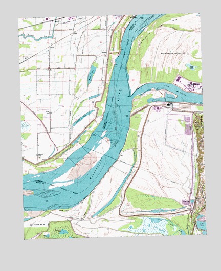
Fletcher Lake, AR USGS Topographic Map
Click on map above to begin viewing in our Map Viewer.

This topographic map contains these locations and features:
Feature Name Type Latitude Longitude GNIS ID View Map
Allen Generating PlantLocaleN35.0740°W90.1490°1275598View Map
AmancaPopulated PlaceN35.1084°W90.2298°57263View Map
Ash SloughStreamN35.0640°W90.2159°45948View Map
Bauxippi-Wyanoke RevetmentLeveeN35.1248°W90.1684°70021View Map
Biggs LandingLocaleN35.0584°W90.2020°57379View Map
C.H. Nash Museum ChucalissaBuildingN35.0623°W90.1301°1648022View Map
Chucalissa Archaeological ParkParkN35.0609°W90.1293°1269460View Map
Chucalissa Indian VillageLocaleN35.0629°W90.1306°1325538View Map
Cockleburr LakeLakeN35.0031°W90.2240°1306011View Map
Commissioner District 11CivilN35.0453°W90.1343°2772136View Map
Cow Island Number Forty-eightIslandN35.0026°W90.2476°1313904View Map
Dismal Point DikesLeveeN35.0490°W90.2059°70229View Map
Dismal Point RevetmentLeveeN35.0756°W90.1915°70230View Map
Ditch Number 17CanalN35.1204°W90.2118°82105View Map
Ditch Number 19CanalN35.0962°W90.2215°82122View Map
Ditch Number 20CanalN35.1173°W90.2018°82149View Map
Ensley PlantationLocaleN35.0668°W90.1709°1325624View Map
Ensley RevetmentLeveeN35.0479°W90.1826°1313574View Map
Fletcher BayouStreamN35.0512°W90.2257°49126View Map
Fletcher LakeLakeN35.0922°W90.2010°74841View Map
Frank C Pidgeon Industrial DevelopmentLocaleN35.0487°W90.1501°1325680View Map
GaletPopulated PlaceN35.1154°W90.2132°49307View Map
Grassy LakeLakeN35.0672°W90.2091°74862View Map
Horn Lake BendBendN35.0120°W90.2098°1306587View Map
Horn Lake CreekStreamN35.0054°W90.1379°690299View Map
Horn Lake CreekStreamN35.0054°W90.1379°1313960View Map
Horn Lake CutoffCanalN35.0423°W90.1337°1313961View Map
Horn Lake PassCanalN35.0101°W90.2254°690301View Map
Josie Harry TowheadFlatN35.0168°W90.2176°1306641View Map
Lake Grove ChurchChurchN35.0956°W90.2304°50944View Map
Lake McKellarLakeN35.0766°W90.1280°1306727View Map
Long Pond (historical)LakeN35.0498°W90.2495°75617View Map
Mallard LakeReservoirN35.0102°W90.1293°1301459View Map
Mallard Lake DamDamN35.0101°W90.1318°1301458View Map
MillersPopulated PlaceN35.0629°W90.2301°77666View Map
Mount Pleasant ChurchChurchN35.0743°W90.2207°67808View Map
New Salem CemeteryCemeteryN35.1176°W90.2270°70244View Map
New Salem ChurchChurchN35.1176°W90.2270°52739View Map
North Horn LakeLakeN35.0010°W90.1413°1295926View Map
Opossum Lake (historical)LakeN35.0848°W90.2448°75619View Map
Presidents Island Number Forty-fiveFlatN35.1043°W90.1315°1306922View Map
QuarlesPopulated PlaceN35.1012°W90.2454°58450View Map
Rainer Industrial ParkLocaleN35.1243°W90.2126°67816View Map
RicevillePopulated PlaceN35.1231°W90.2259°58485View Map
Riceville School (historical)SchoolN35.1176°W90.2279°70250View Map
Round LakeLakeN35.0944°W90.1320°1300159View Map
Saint John Church (historical)ChurchN35.0529°W90.2187°67821View Map
Saint Johns CemeteryCemeteryN35.0706°W90.2306°70258View Map
Saint Johns ChurchChurchN35.0709°W90.2304°78242View Map
Township of ProctorCivilN35.0826°W90.2466°68753View Map
United States Tennessee Valley Authority Allen Fossil PlantLocaleN35.0736°W90.1489°2425896View Map
Vice Presidents Island Number Forty-sixFlatN35.1159°W90.1576°1273446View Map
WaverlyPopulated PlaceN35.0470°W90.2390°56120View Map
Waverly School (historical)SchoolN35.0706°W90.2301°70259View Map
Waverly School (historical)SchoolN35.0434°W90.2395°70260View Map
Womacks LandingLocaleN35.0362°W90.2482°67847View Map
Wyanke School (historical)SchoolN35.0854°W90.2118°67851View Map
WyanokePopulated PlaceN35.1040°W90.1901°78812View Map
Wyanoke CrevasseBasinN35.0743°W90.1973°70262View Map
Wyanoke Dikes (historical)LeveeN35.0995°W90.1834°70263View Map

Note: Coordinates in the location and feature list above are referenced to NAD83 datum.


Copyright (C) 2008-2024 Ryan Niemi / Sunset Dynamics ... All Rights Reserved