TopoQuest Logo
Do you find TopoQuest useful?
Help keep TopoQuest running and adding new maps/features by donating!
Bitcoin:  19c7KJd3qBynnjoSw5npx9KScwjBe4ifkT
Litecoin:  LXs6TkuXGGXo1vDsWCkWVdjQX94eUKd6ui
Home View Maps Find Maps Find Places Resources & Links


Edmondson, Arkansas Topographic Map

USGS Map Title: Edmondson, AR
USGS Map MRC: 35090A3
DRG (GeoTIFF) Download: o35090a3.tif


Neighboring USGS Topographic Map Quads:


  Jeanette, AR  
35090B4
 

  Crawfordsville, AR  
35090B3
 

  West Memphis, AR  
35090B2
 

  Chatfield, AR  
35090A4
 

  Edmondson, AR  
35090A3
 

  Fletcher Lake, AR  
35090A2
 

  Hughes, AR  
34090H4
 

  Horseshoe Lake, AR  
34090H3
 

  Lake Cormorant, MS  
34090H2


Map MRC Location:

N36°
W91°
N36°
W90°
H8 H7 H6 H5 H4 H3 H2 H1
G8 G7 G6 G5 G4 G3 G2 G1
F8 F7 F6 F5 F4 F3 F2 F1
E8 E7 E6 E5 E4 E3 E2 E1
D8 D7 D6 D5 D4 D3 D2 D1
C8 C7 C6 C5 C4 C3 C2 C1
B8 B7 B6 B5 B4 B3 B2 B1
A8 A7 A6 A5 A4 A3 A2 A1
N35°
W91°
N35°
W90°

Edmondson, AR USGS 1:24K Topographic Map Preview:
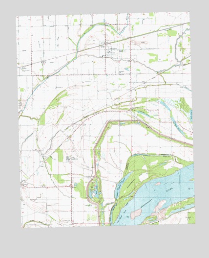
Edmondson, AR USGS Topographic Map
Click on map above to begin viewing in our Map Viewer.

This topographic map contains these locations and features:
Feature Name Type Latitude Longitude GNIS ID View Map
Anthony SubdivisionPopulated PlaceN35.0398°W90.3404°83624View Map
AnthonyvillePopulated PlaceN35.0395°W90.3409°1852795View Map
Anthonyville Volunteer Fire DepartmentBuildingN35.0379°W90.3416°2116083View Map
Beaver SloughStreamN35.0423°W90.3526°76274View Map
Bell Meade ChurchChurchN35.0829°W90.2684°46356View Map
Bell Meade SchoolSchoolN35.0831°W90.2695°46357View Map
Bellmeade Church (historical)ChurchN35.0834°W90.2826°75615View Map
Bellmeade School (historical)SchoolN35.0837°W90.2826°75616View Map
Blue LakeLakeN35.0208°W90.3203°46754View Map
Blue Point TowheadBuildingN35.0167°W90.3000°2676059View Map
BricePopulated PlaceN35.0843°W90.2832°57436View Map
Clay Brook SchoolSchoolN35.0393°W90.3595°47814View Map
Claybrook ChurchChurchN35.0395°W90.3595°47818View Map
Copperas LakeLakeN35.0655°W90.2850°48033View Map
Cow Island BendBendN35.0034°W90.3040°48119View Map
Cut-off BayouStreamN35.0687°W90.3712°83117View Map
Decker BayouStreamN35.0829°W90.2684°48436View Map
Ditch Number 12CanalN35.1131°W90.3254°82057View Map
EdmondsonPopulated PlaceN35.1065°W90.3104°57701View Map
Edmondson CemeteryCemeteryN35.0898°W90.3012°48819View Map
Edmondson Police DepartmentBuildingN35.1028°W90.3082°2118551View Map
Edmondson Volunteer Fire DepartmentBuildingN35.1026°W90.3083°2116391View Map
Edmonson Post OfficePost OfficeN35.1025°W90.3065°2773495View Map
Friendship SchoolSchoolN35.0276°W90.3734°49271View Map
Graves BayouLakeN35.0133°W90.3116°49597View Map
KatePopulated PlaceN35.0448°W90.3615°58004View Map
Long PondLakeN35.0617°W90.2640°74994View Map
Lost CreekStreamN35.0120°W90.3207°51457View Map
LouisePopulated PlaceN35.0765°W90.2937°58091View Map
Midway CornerPopulated PlaceN35.0687°W90.2937°58177View Map
MoundsPopulated PlaceN35.1151°W90.2670°58219View Map
Mount Olive ChurchChurchN35.0643°W90.2743°52354View Map
NeuhardtPopulated PlaceN35.0612°W90.3290°58251View Map
New Bethel ChurchChurchN35.0826°W90.3473°52625View Map
Ninetysix CornerPopulated PlaceN35.0237°W90.3376°58268View Map
Ninetysix LandingLocaleN35.0090°W90.3107°75618View Map
PatokaPopulated PlaceN35.0734°W90.3112°58332View Map
ProctorPopulated PlaceN35.0951°W90.3734°58435View Map
Proctor Post OfficePost OfficeN35.0671°W90.2982°2781949View Map
Proctor Volunteer Fire DepartmentBuildingN35.0672°W90.2970°2625425View Map
SimsboroPopulated PlaceN35.0254°W90.3732°58629View Map
Sunrise ChurchChurchN35.1134°W90.2715°55345View Map
Swan LakeLakeN35.0518°W90.2534°75160View Map
Swan Lake DamDamN35.0518°W90.2534°79635View Map
Tenmile BayouStreamN35.0437°W90.3582°78531View Map
ThompsonPopulated PlaceN35.0051°W90.3390°58740View Map
TopazPopulated PlaceN35.0365°W90.3593°58755View Map
Town of AnthonyvilleCivilN35.0397°W90.3405°2405155View Map
Town of EdmondsonCivilN35.1045°W90.3051°2406425View Map
Township of Bob WardCivilN35.0673°W90.3514°68746View Map
Truevine CemeteryCemeteryN35.0665°W90.3193°55670View Map
Truevine ChurchChurchN35.0662°W90.3193°55671View Map
Twentymile BayouStreamN35.0690°W90.3729°78603View Map
Warehouse BayouStreamN35.0868°W90.3554°56057View Map
Wedlock Elementary SchoolSchoolN35.1001°W90.3137°75620View Map

Note: Coordinates in the location and feature list above are referenced to NAD83 datum.


Copyright (C) 2008-2025 Ryan Niemi / Sunset Dynamics ... All Rights Reserved