TopoQuest Logo
Do you find TopoQuest useful?
Help keep TopoQuest running and adding new maps/features by donating!
Bitcoin:  19c7KJd3qBynnjoSw5npx9KScwjBe4ifkT
Litecoin:  LXs6TkuXGGXo1vDsWCkWVdjQX94eUKd6ui
Home View Maps Find Maps Find Places Resources & Links


Flint, Idaho Topographic Map

USGS Map Title: Flint, ID
USGS Map MRC: 42116H7
DRG (GeoTIFF) Download: o42116h7.tif


Neighboring USGS Topographic Map Quads:


  Swisher Mountain, ID  
43116A8
 

  De Lamar, ID  
43116A7
 

  Silver City, ID  
43116A6
 

  Stonehouse Creek, ID  
42116H8
 

  Flint, ID  
42116H7
 

  Cinnabar Mountain, ID  
42116H6
 

  Williams Creek, ID  
42116G8
 

  Combination Ridge, ID  
42116G7
 

  Triangle Flat, ID  
42116G6


Map MRC Location:

N43°
W117°
N43°
W116°
H8 H7 H6 H5 H4 H3 H2 H1
G8 G7 G6 G5 G4 G3 G2 G1
F8 F7 F6 F5 F4 F3 F2 F1
E8 E7 E6 E5 E4 E3 E2 E1
D8 D7 D6 D5 D4 D3 D2 D1
C8 C7 C6 C5 C4 C3 C2 C1
B8 B7 B6 B5 B4 B3 B2 B1
A8 A7 A6 A5 A4 A3 A2 A1
N42°
W117°
N42°
W116°

Flint, ID USGS 1:24K Topographic Map Preview:
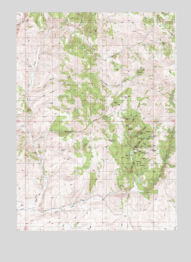
Flint, ID USGS Topographic Map
Click on map above to begin viewing in our Map Viewer.

This topographic map contains these locations and features:
Feature Name Type Latitude Longitude GNIS ID View Map
Astor GulchValleyN42.9224°W116.7843°371305View Map
Barrel SpringSpringN42.9518°W116.7910°371370View Map
Big I GradeTrailN42.9935°W116.8474°398577View Map
Big Sawmill CreekStreamN42.9474°W116.8662°371520View Map
Black WarriorSummitN42.9204°W116.7687°371583View Map
Buck CreekStreamN42.9157°W116.8568°371733View Map
Corral GulchValleyN42.9246°W116.7765°372139View Map
Cottonwood CreekStreamN42.9732°W116.8129°372157View Map
Crescent MineMineN42.9293°W116.7690°372255View Map
De Lamar SpringSpringN42.9824°W116.7621°372326View Map
Dewey PeakSummitN42.9265°W116.8007°372399View Map
Doughboy MineMineN42.9329°W116.7882°372447View Map
East CreekStreamN42.8982°W116.7857°372545View Map
FlintPopulated PlaceN42.9165°W116.7829°396498View Map
Flint CreekStreamN42.8871°W116.8651°372734View Map
Hard Up GulchValleyN42.9285°W116.8651°399908View Map
Hinke GulchValleyN42.9435°W116.8632°373085View Map
Hornet MineMineN42.9349°W116.7882°373135View Map
Jefferson MineMineN42.9388°W116.7907°373302View Map
Little Sawmill CreekStreamN42.9552°W116.8662°373669View Map
Louse CreekStreamN42.9346°W116.8693°373743View Map
Mine GulchValleyN42.9193°W116.7857°373966View Map
Nellie Ann MineMineN42.9477°W116.7973°374115View Map
Perseverance MineMineN42.9210°W116.7793°374370View Map
Rising Star MineMineN42.9193°W116.7773°374692View Map
Silver Queen MineMineN42.9279°W116.7768°375031View Map
Sullivan GulchValleyN42.9910°W116.8274°375330View Map
Treasure Vault MineMineN42.9304°W116.7796°375573View Map
Twilight GulchValleyN42.9285°W116.7862°375615View Map
Washington GulchValleyN42.9254°W116.8629°375747View Map

Note: Coordinates in the location and feature list above are referenced to NAD83 datum.


Copyright (C) 2008-2025 Ryan Niemi / Sunset Dynamics ... All Rights Reserved