TopoQuest Logo
Do you find TopoQuest useful?
Help keep TopoQuest running and adding new maps/features by donating!
Bitcoin:  19c7KJd3qBynnjoSw5npx9KScwjBe4ifkT
Litecoin:  LXs6TkuXGGXo1vDsWCkWVdjQX94eUKd6ui
Home View Maps Find Maps Find Places Resources & Links


Floridale, Florida Topographic Map

USGS Map Title: Floridale, FL
USGS Map MRC: 30086F7
DRG (GeoTIFF) Download: o30086f7.tif


Neighboring USGS Topographic Map Quads:


  Spring Hill, FL  
30086G8
 

  Munson, FL  
30086G7
 

  Baker, FL  
30086G6
 

  Harold, FL  
30086F8
 

  Floridale, FL  
30086F7
 

  Holt, FL  
30086F6
 

  Ward Basin, FL  
30086E8
 

  Harold SE, FL  
30086E7
 

  Holt SW, FL  
30086E6


Map MRC Location:

N31°
W87°
N31°
W86°
H8 H7 H6 H5 H4 H3 H2 H1
G8 G7 G6 G5 G4 G3 G2 G1
F8 F7 F6 F5 F4 F3 F2 F1
E8 E7 E6 E5 E4 E3 E2 E1
D8 D7 D6 D5 D4 D3 D2 D1
C8 C7 C6 C5 C4 C3 C2 C1
B8 B7 B6 B5 B4 B3 B2 B1
A8 A7 A6 A5 A4 A3 A2 A1
N30°
W87°
N30°
W86°

Floridale, FL USGS 1:24K Topographic Map Preview:
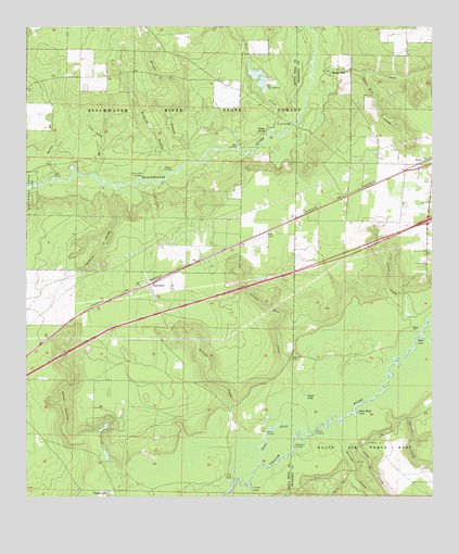
Floridale, FL USGS Topographic Map
Click on map above to begin viewing in our Map Viewer.

This topographic map contains these locations and features:
Feature Name Type Latitude Longitude GNIS ID View Map
Adams Mill CreekStreamN30.7374°W86.7727°277681View Map
Ates CreekStreamN30.7249°W86.7933°277976View Map
Bone CreekStreamN30.7410°W86.7858°279201View Map
Bryant BridgeBridgeN30.7244°W86.7925°279535View Map
Buck BranchStreamN30.6313°W86.7750°279554View Map
Butter LandingLocaleN30.7124°W86.8300°295166View Map
Camp CreekStreamN30.6391°W86.7727°279890View Map
Canoe CreekStreamN30.6680°W86.7552°279992View Map
Carr LakeLakeN30.6524°W86.8055°298119View Map
Carroll CreekStreamN30.6513°W86.7597°280074View Map
Center Fait LandingLocaleN30.7105°W86.8391°295187View Map
Coon Camp BranchStreamN30.7110°W86.8538°280748View Map
Crane LakeLakeN30.6274°W86.8058°281000View Map
FloridalePopulated PlaceN30.6816°W86.8369°294771View Map
Garnier CreekStreamN30.6460°W86.8108°282945View Map
Garnier LandingLocaleN30.6421°W86.8016°295313View Map
George T Mc Cutchan AirportAirportN30.6735°W86.8519°309477View Map
Guest LakeLakeN30.6515°W86.7895°283481View Map
Harold Census Designated PlaceCensusN30.6772°W86.8309°2583351View Map
Harold DivisionCivilN30.6670°W86.8510°2583394View Map
Holt Volunteer Fire DistrictBuildingN30.7132°W86.7508°2644058View Map
Hynote BranchStreamN30.7094°W86.8683°284448View Map
Julian Mill CreekStreamN30.6544°W86.7911°284963View Map
Kellys MillPopulated PlaceN30.7380°W86.7761°295387View Map
Mason LandingLocaleN30.6421°W86.7861°295434View Map
Milligan CreekStreamN30.6388°W86.7761°286930View Map
New Canoe CemeteryCemeteryN30.6630°W86.7930°287607View Map
Penny CreekStreamN30.7485°W86.7852°288695View Map
Pine Bluff LakeLakeN30.6475°W86.7730°288826View Map
Pitts RiverStreamN30.6338°W86.8033°289012View Map
Pleasant Home CemeteryCemeteryN30.7369°W86.8613°301628View Map
Pleasant Home ChurchChurchN30.7369°W86.8613°301629View Map
R B Squirls PondLakeN30.6436°W86.8511°298124View Map
Riley BluffCliffN30.7216°W86.8011°289701View Map
Riley LandingLocaleN30.7182°W86.8097°295577View Map
Shingle BranchStreamN30.7152°W86.8211°291052View Map
Sigler LakeLakeN30.6666°W86.7549°291100View Map
Sweetgum LandingLocaleN30.6380°W86.7922°295661View Map
Tarkiln Head HollowValleyN30.7060°W86.8507°292031View Map
Wolftrap BranchStreamN30.7113°W86.8313°293480View Map
Yellow River AirstripAirportN30.6857°W86.7512°309498View Map

Note: Coordinates in the location and feature list above are referenced to NAD83 datum.


Copyright (C) 2008-2025 Ryan Niemi / Sunset Dynamics ... All Rights Reserved