TopoQuest Logo
Do you find TopoQuest useful?
Help keep TopoQuest running and adding new maps/features by donating!
Bitcoin:  19c7KJd3qBynnjoSw5npx9KScwjBe4ifkT
Litecoin:  LXs6TkuXGGXo1vDsWCkWVdjQX94eUKd6ui
Home View Maps Find Maps Find Places Resources & Links


Winthrop, Arkansas Topographic Map

USGS Map Title: Winthrop, AR
USGS Map MRC: 33094G3
DRG (GeoTIFF) Download: o33094g3.tif


Neighboring USGS Topographic Map Quads:


  Cerrogordo, AR  
33094H4
 

  Horatio, AR  
33094H3
 

  Lockesburg, AR  
33094H2
 

  Arkinda, AR  
33094G4
 

  Winthrop, AR  
33094G3
 

  Falls Chapel, AR  
33094G2
 

  Foreman, AR  
33094F4
 

  Arden, AR  
33094F3
 

  Ashdown West, AR  
33094F2


Map MRC Location:

N34°
W95°
N34°
W94°
H8 H7 H6 H5 H4 H3 H2 H1
G8 G7 G6 G5 G4 G3 G2 G1
F8 F7 F6 F5 F4 F3 F2 F1
E8 E7 E6 E5 E4 E3 E2 E1
D8 D7 D6 D5 D4 D3 D2 D1
C8 C7 C6 C5 C4 C3 C2 C1
B8 B7 B6 B5 B4 B3 B2 B1
A8 A7 A6 A5 A4 A3 A2 A1
N33°
W95°
N33°
W94°

Winthrop, AR USGS 1:24K Topographic Map Preview:
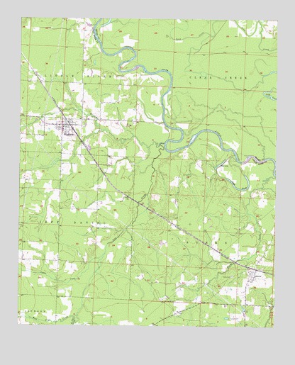
Winthrop, AR USGS Topographic Map
Click on map above to begin viewing in our Map Viewer.

This topographic map contains these locations and features:
Feature Name Type Latitude Longitude GNIS ID View Map
AlleenePopulated PlaceN33.7701°W94.2605°76158View Map
Alleene Baptist ChurchChurchN33.7721°W94.2621°60075View Map
Alleene CemeteryCemeteryN33.7704°W94.2716°45826View Map
Alleene Fire DepartmentBuildingN33.7727°W94.2627°2116064View Map
Alleene Post OfficePost OfficeN33.7728°W94.2597°83888View Map
Alleene School (historical)SchoolN33.7723°W94.2630°60076View Map
Boggy SloughLakeN33.8064°W94.2691°76396View Map
Calton CreekStreamN33.7796°W94.3330°70963View Map
City of WinthropCivilN33.8308°W94.3543°2405777View Map
Cotton Woods ShoalsBarN33.8168°W94.2671°67322View Map
East Flat CreekStreamN33.7537°W94.3483°71498View Map
Flat CreekStreamN33.8240°W94.3071°49093View Map
Freeman CemeteryCemeteryN33.7534°W94.2724°49238View Map
Hawkins FordCrossingN33.8168°W94.2671°67323View Map
Hurricane CreekStreamN33.8246°W94.3049°72119View Map
Leidygate (historical)Populated PlaceN33.7868°W94.2905°60133View Map
Lippton (historical)Populated PlaceN33.7918°W94.3002°60134View Map
Red LakeLakeN33.8166°W94.2770°77305View Map
Roberts BranchStreamN33.8748°W94.2794°58501View Map
Township of BurkeCivilN33.7595°W94.2909°66833View Map
Township of Little RiverCivilN33.8424°W94.3525°66841View Map
West Flat CreekStreamN33.7537°W94.3485°74059View Map
WinthropPopulated PlaceN33.8318°W94.3546°78791View Map
Winthrop Elementary SchoolSchoolN33.8300°W94.3546°60190View Map
Winthrop Fire DepartmentBuildingN33.8314°W94.3516°2117327View Map
Winthrop High SchoolSchoolN33.8296°W94.3541°60191View Map
Yellow Banks LandingLocaleN33.8437°W94.3058°67324View Map

Note: Coordinates in the location and feature list above are referenced to NAD83 datum.


Copyright (C) 2008-2025 Ryan Niemi / Sunset Dynamics ... All Rights Reserved