TopoQuest Logo
Do you find TopoQuest useful?
Help keep TopoQuest running and adding new maps/features by donating!
Bitcoin:  19c7KJd3qBynnjoSw5npx9KScwjBe4ifkT
Litecoin:  LXs6TkuXGGXo1vDsWCkWVdjQX94eUKd6ui
Home View Maps Find Maps Find Places Resources & Links


Forksville, Virginia Topographic Map

USGS Map Title: Forksville, VA
USGS Map MRC: 36078G1
DRG (GeoTIFF) Download: o36078g1.tif


Neighboring USGS Topographic Map Quads:


  Kenbridge West, VA  
36078H2
 

  Kenbridge East, VA  
36078H1
 

  Danieltown, VA  
36077H8
 

  North View, VA  
36078G2
 

  Forksville, VA  
36078G1
 

  Alberta, VA  
36077G8
 

  South Hill, VA  
36078F2
 

  La Crosse, VA  
36078F1
 

  White Plains, VA  
36077F8


Map MRC Location:

N37°
W79°
N37°
W78°
H8 H7 H6 H5 H4 H3 H2 H1
G8 G7 G6 G5 G4 G3 G2 G1
F8 F7 F6 F5 F4 F3 F2 F1
E8 E7 E6 E5 E4 E3 E2 E1
D8 D7 D6 D5 D4 D3 D2 D1
C8 C7 C6 C5 C4 C3 C2 C1
B8 B7 B6 B5 B4 B3 B2 B1
A8 A7 A6 A5 A4 A3 A2 A1
N36°
W79°
N36°
W78°

Forksville, VA USGS 1:24K Topographic Map Preview:
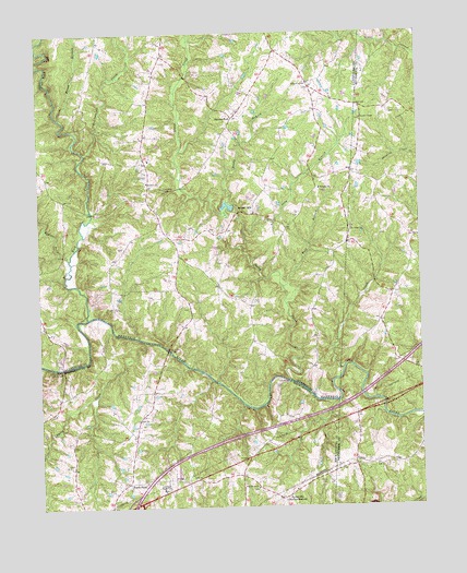
Forksville, VA USGS Topographic Map
Click on map above to begin viewing in our Map Viewer.

This topographic map contains these locations and features:
Feature Name Type Latitude Longitude GNIS ID View Map
Aaron CreekStreamN36.7863°W78.0256°1462317View Map
Antioch ChurchChurchN36.8354°W78.0883°1462496View Map
Bacons ForkPopulated PlaceN36.8524°W78.0600°1477089View Map
Beaver Creek DistrictCivilN36.8612°W78.1104°1927088View Map
Beaver Pond CreekStreamN36.8154°W78.1147°1462942View Map
Bold BranchStreamN36.8079°W78.0444°1463637View Map
Booker School (historical)SchoolN36.7568°W78.0728°1500624View Map
Broad BranchStreamN36.8529°W78.1172°1463838View Map
Burnt StoreLocaleN36.7565°W78.0961°1464142View Map
Crestview Memorial ParkCemeteryN36.7551°W78.0839°1465425View Map
Dix BridgeBridgeN36.7832°W78.0428°1465832View Map
Flat Rock CreekStreamN36.7996°W78.1089°1466657View Map
ForksvillePopulated PlaceN36.7524°W78.0461°1494935View Map
Friendship ChurchChurchN36.8335°W78.0822°1466895View Map
Gills CornerPopulated PlaceN36.8607°W78.0350°1477352View Map
Hawthorne High BridgeBridgeN36.7868°W78.1175°1467853View Map
Hite CemeteryCemeteryN36.8060°W78.0892°1492160View Map
Interchange 15CrossingN36.7507°W78.0944°1500722View Map
Kettlesticks CreekStreamN36.8435°W78.1089°1468983View Map
LochlevenPopulated PlaceN36.8704°W78.0461°1492171View Map
Lochleven Post Office (historical)Post OfficeN36.8704°W78.0461°1492172View Map
Lochleven School (historical)SchoolN36.8415°W78.0881°1492173View Map
Long BranchStreamN36.8232°W78.0567°1469760View Map
McDaniel CemeteryCemeteryN36.8696°W78.0469°1492182View Map
Neblett CemeteryCemeteryN36.8676°W78.0839°1492186View Map
Oliver Church (historical)ChurchN36.7576°W78.0328°1500777View Map
Olivet CemeteryCemeteryN36.7574°W78.0322°1471913View Map
Providence CemeteryCemeteryN36.7549°W78.0542°1500792View Map
Providence ChurchChurchN36.7551°W78.0539°1472816View Map
Reedy BranchStreamN36.8299°W78.0617°1473102View Map
Smith CreekStreamN36.7940°W78.0903°1474748View Map
Stones MillPopulated PlaceN36.8279°W78.0583°1495139View Map
Stony CreekStreamN36.7835°W78.0425°1475206View Map
Taylors ChapelChurchN36.8521°W78.0181°1475514View Map
Union ChurchChurchN36.7729°W78.0931°1476037View Map
Union Mill (historical)LocaleN36.7938°W78.0906°1500845View Map
Union Mill BridgeBridgeN36.7913°W78.0825°1476087View Map
Williams ChurchChurchN36.8335°W78.0319°1476760View Map
Zion Union ChurchChurchN36.8232°W78.0222°1474426View Map

Note: Coordinates in the location and feature list above are referenced to NAD83 datum.


Copyright (C) 2008-2025 Ryan Niemi / Sunset Dynamics ... All Rights Reserved