TopoQuest Logo
Do you find TopoQuest useful?
Help keep TopoQuest running and adding new maps/features by donating!
Bitcoin:  19c7KJd3qBynnjoSw5npx9KScwjBe4ifkT
Litecoin:  LXs6TkuXGGXo1vDsWCkWVdjQX94eUKd6ui
Home View Maps Find Maps Find Places Resources & Links


White Plains, Virginia Topographic Map

USGS Map Title: White Plains, VA
USGS Map MRC: 36077F8
DRG (GeoTIFF) Download: o36077f8.tif


Neighboring USGS Topographic Map Quads:


  Forksville, VA  
36078G1
 

  Alberta, VA  
36077G8
 

  Lawrenceville, VA  
36077G7
 

  La Crosse, VA  
36078F1
 

  White Plains, VA  
36077F8
 

  Powellton, VA  
36077F7
 

  South Hill SE, VA  
36078E1
 

  Gasburg, VA  
36077E8
 

  Valentines, VA  
36077E7


Map MRC Location:

N37°
W78°
N37°
W77°
H8 H7 H6 H5 H4 H3 H2 H1
G8 G7 G6 G5 G4 G3 G2 G1
F8 F7 F6 F5 F4 F3 F2 F1
E8 E7 E6 E5 E4 E3 E2 E1
D8 D7 D6 D5 D4 D3 D2 D1
C8 C7 C6 C5 C4 C3 C2 C1
B8 B7 B6 B5 B4 B3 B2 B1
A8 A7 A6 A5 A4 A3 A2 A1
N36°
W78°
N36°
W77°

White Plains, VA USGS 1:24K Topographic Map Preview:
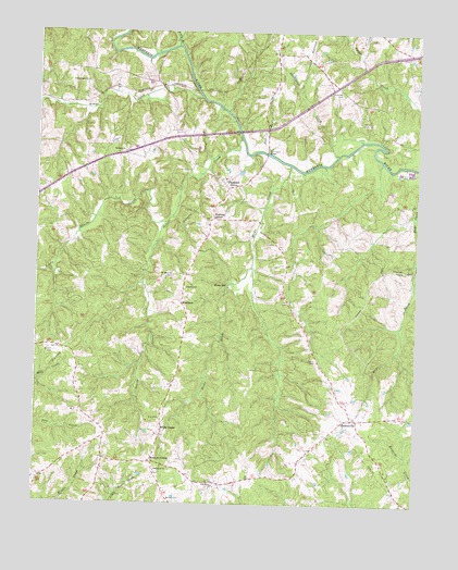
White Plains, VA USGS Topographic Map
Click on map above to begin viewing in our Map Viewer.

This topographic map contains these locations and features:
Feature Name Type Latitude Longitude GNIS ID View Map
Bethany ChurchChurchN36.7182°W77.9717°1463117View Map
Bethlehem Church (historical)ChurchN36.6326°W77.9972°1493956View Map
Bishop CemeteryCemeteryN36.6265°W77.9555°1463460View Map
Bowers CornerPopulated PlaceN36.6363°W77.9608°1477134View Map
Briery BranchStreamN36.7463°W77.9544°1463821View Map
Carroll CemeteryCemeteryN36.6649°W77.9942°1464460View Map
Davis CemeteryCemeteryN36.7265°W77.8936°1465637View Map
Diamond GrovePopulated PlaceN36.7088°W77.9369°1499340View Map
Evans CreekStreamN36.7326°W77.9467°1466355View Map
Flat BranchStreamN36.7179°W77.9236°1466642View Map
Flournoy CemeteryCemeteryN36.7349°W77.9000°1466733View Map
Genito CreekStreamN36.7224°W77.9333°1467030View Map
GholsonvillePopulated PlaceN36.6476°W77.8953°1477347View Map
Gholsonville School (historical)SchoolN36.6335°W77.9130°1493980View Map
Grace Church (historical)ChurchN36.7118°W77.9397°1493982View Map
Hicks CreekStreamN36.7149°W77.9167°1467995View Map
Hicks MillPopulated PlaceN36.6824°W77.9367°1499552View Map
Holy Sunrise Church (historical)ChurchN36.7096°W77.9986°1493986View Map
Little Genito CreekStreamN36.6996°W77.9581°1469551View Map
Little Union ChurchChurchN36.7368°W77.9844°1469678View Map
Meherrin DistrictCivilN36.6316°W77.9458°1927400View Map
Meherrin School (historical)SchoolN36.6429°W77.9761°1494008View Map
MerchantPopulated PlaceN36.6782°W77.9519°1499732View Map
Mount Olive ChurchChurchN36.6857°W77.9547°1470962View Map
Netta (historical)Populated PlaceN36.7351°W77.9736°1494011View Map
Netta Church (historical)ChurchN36.7199°W77.9528°1494012View Map
Oak Grove ChurchChurchN36.6296°W77.9403°1471701View Map
Oakley School (historical)SchoolN36.7460°W77.8808°1494014View Map
Paradise ChurchChurchN36.6818°W77.9508°1472050View Map
Pennington BridgeBridgeN36.7185°W77.9233°1472188View Map
Saddletree CreekStreamN36.7179°W77.9008°1473688View Map
Solomons Temple (historical)ChurchN36.7446°W77.9139°1494032View Map
Tabernacle ChurchChurchN36.6335°W77.9600°1475424View Map
Taylor CemeteryCemeteryN36.6632°W77.9075°1475502View Map
Union Church (historical)ChurchN36.7332°W77.9008°1494038View Map
Watkins CornerPopulated PlaceN36.7007°W77.9422°1500285View Map
White PlainsPopulated PlaceN36.6443°W77.9583°1500311View Map
White Plains Post OfficePost OfficeN36.6446°W77.9583°2767268View Map
White Plains School (historical)SchoolN36.6318°W77.9589°1494045View Map
Wray CemeteryCemeteryN36.6476°W77.9583°1476996View Map

Note: Coordinates in the location and feature list above are referenced to NAD83 datum.


Copyright (C) 2008-2025 Ryan Niemi / Sunset Dynamics ... All Rights Reserved