TopoQuest Logo
Do you find TopoQuest useful?
Help keep TopoQuest running and adding new maps/features by donating!
Bitcoin:  19c7KJd3qBynnjoSw5npx9KScwjBe4ifkT
Litecoin:  LXs6TkuXGGXo1vDsWCkWVdjQX94eUKd6ui
Home View Maps Find Maps Find Places Resources & Links


Hulbert, Oklahoma Topographic Map

USGS Map Title: Hulbert, OK
USGS Map MRC: 35095H2
DRG (GeoTIFF) Download: o35095h2.tif


Neighboring USGS Topographic Map Quads:


  Rocky Point, OK  
36095A3
 

  Cedar Crest, OK  
36095A2
 

  Peggs, OK  
36095A1
 

  Wagoner East, OK  
35095H3
 

  Hulbert, OK  
35095H2
 

  Thompson Corner, OK  
35095H1
 

  Northeast Muskogee, OK  
35095G3
 

  Fort Gibson Dam, OK  
35095G2
 

  Zeb, OK  
35095G1


Map MRC Location:

N36°
W96°
N36°
W95°
H8 H7 H6 H5 H4 H3 H2 H1
G8 G7 G6 G5 G4 G3 G2 G1
F8 F7 F6 F5 F4 F3 F2 F1
E8 E7 E6 E5 E4 E3 E2 E1
D8 D7 D6 D5 D4 D3 D2 D1
C8 C7 C6 C5 C4 C3 C2 C1
B8 B7 B6 B5 B4 B3 B2 B1
A8 A7 A6 A5 A4 A3 A2 A1
N35°
W96°
N35°
W95°

Hulbert, OK USGS 1:24K Topographic Map Preview:
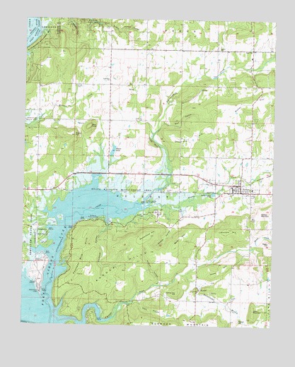
Hulbert, OK USGS Topographic Map
Click on map above to begin viewing in our Map Viewer.

This topographic map contains these locations and features:
Feature Name Type Latitude Longitude GNIS ID View Map
Abidoe HollowValleyN35.9180°W95.1765°1089511View Map
Bald HillSummitN35.9101°W95.1713°1089801View Map
Bald KnobSummitN35.9562°W95.2175°1089808View Map
Biscuit HillSummitN35.8773°W95.1419°1090165View Map
Brushy HillSummitN35.9526°W95.2250°1090575View Map
Butler HillSummitN35.9604°W95.1469°1090751View Map
Cedar BluffCliffN35.9498°W95.1852°1091056View Map
Chucalate HillSummitN35.9532°W95.1647°1091350View Map
Cockrum HollowValleyN35.9154°W95.2072°1763567View Map
Cockrun HollowValleyN35.9193°W95.2078°1091533View Map
Cook HollowValleyN35.8848°W95.1930°1091622View Map
Double Spring CreekStreamN35.9226°W95.1891°1092155View Map
EliPopulated PlaceN35.9876°W95.1894°1100386View Map
Flint RidgeRidgeN35.8895°W95.1627°1092901View Map
Fort Gibson Wildlife Management AreaParkN35.8890°W95.2002°1763565View Map
Fourteen Mile HillsSummitN35.9023°W95.2191°1093001View Map
Hare CemeteryCemeteryN35.9965°W95.2097°1093535View Map
Hicks HillSummitN35.8984°W95.1505°1093723View Map
Hinson CemeteryCemeteryN35.9729°W95.2247°1093793View Map
Hinton HollowValleyN35.9956°W95.2022°1093796View Map
HulbertPopulated PlaceN35.9326°W95.1413°1094010View Map
Hulbert CemeteryCemeteryN35.9304°W95.1794°1094011View Map
Hulbert DivisionCivilN35.9345°W95.1703°1937739View Map
Hulbert Elementary SchoolSchoolN35.9319°W95.1446°1803550View Map
Hulbert Fire DepartmentBuildingN35.9332°W95.1399°2656835View Map
Hulbert Junior High SchoolSchoolN35.9314°W95.1454°1790368View Map
Hulbert Landing Public Use AreaParkN35.9257°W95.1888°1094012View Map
Hulbert Police DepartmentBuildingN35.9329°W95.1441°2757612View Map
Hulbert Senior High SchoolSchoolN35.9310°W95.1454°2713169View Map
Jim Brown HollowValleyN35.8825°W95.1466°1094224View Map
Johnny Iron HillSummitN35.8884°W95.1725°1094240View Map
Keener CemeteryCemeteryN35.9894°W95.1522°2711311View Map
Keener ChurchChurchN35.9884°W95.1525°1094308View Map
Limestone HillSummitN35.9145°W95.1469°1094653View Map
Linder CemeteryCemeteryN35.8865°W95.1450°1094689View Map
Lost CityPopulated PlaceN35.9879°W95.1363°1100593View Map
Lost City CemeteryCemeteryN35.9833°W95.1367°2711312View Map
Lost City Elementary SchoolSchoolN35.9848°W95.1369°1803549View Map
Lower Ray CemeteryCemeteryN35.9593°W95.1905°1095033View Map
Melvin ChurchChurchN35.9207°W95.1827°1095304View Map
Negro HillSummitN35.9090°W95.1266°1095776View Map
Nichols HollowValleyN35.8920°W95.1816°1095868View Map
Norwood Fire Department Station 2BuildingN35.8870°W95.2200°2657058View Map
Norwood MountainSummitN35.8776°W95.1688°1096065View Map
Pecan CreekStreamN35.8959°W95.1686°1096527View Map
Peckerwood HillSummitN35.9123°W95.1880°1096532View Map
Ranger CreekStreamN35.8790°W95.2347°1097046View Map
Ranger HillsRangeN35.8979°W95.2025°1097047View Map
Rattlesnake BranchStreamN35.8957°W95.1680°1097056View Map
Rogers PondReservoirN35.9484°W95.1869°1751211View Map
Rogers PondReservoirN35.9464°W95.2057°1097397View Map
Rogers Pond DamDamN35.9484°W95.1869°1751210View Map
Sequoyah Park Airport (historical)AirportN35.9126°W95.2419°1102725View Map
Short MountainSummitN35.8815°W95.1341°1098025View Map
Spring Valley Volunteer Fire Department Station 1BuildingN35.9881°W95.1770°2657244View Map
Spring Valley Volunteer Fire Department Station 2BuildingN35.9299°W95.2380°2657084View Map
Town of HulbertCivilN35.9315°W95.1437°2412779View Map
Township of HulbertCivilN35.9279°W95.1905°1824587View Map
Waford MountainSummitN35.9226°W95.1280°1099285View Map
Western Hill LodgeLocaleN35.8884°W95.2416°1099629View Map
Wildwood Public Use AreaParkN35.9182°W95.2147°1099807View Map
Wolf HollowValleyN35.9579°W95.1805°1099965View Map

Note: Coordinates in the location and feature list above are referenced to NAD83 datum.


Copyright (C) 2008-2024 Ryan Niemi / Sunset Dynamics ... All Rights Reserved