TopoQuest Logo
Do you find TopoQuest useful?
Help keep TopoQuest running and adding new maps/features by donating!
Bitcoin:  19c7KJd3qBynnjoSw5npx9KScwjBe4ifkT
Litecoin:  LXs6TkuXGGXo1vDsWCkWVdjQX94eUKd6ui
Home View Maps Find Maps Find Places Resources & Links


Fort Lawn, South Carolina Topographic Map

USGS Map Title: Fort Lawn, SC
USGS Map MRC: 34080F8
DRG (GeoTIFF) Download: o34080f8.tif


Neighboring USGS Topographic Map Quads:


  Edgemoor, SC  
34081G1
 

  Catawba, SC  
34080G8
 

  Van Wyck, SC  
34080G7
 

  Richburg, SC  
34081F1
 

  Fort Lawn, SC  
34080F8
 

  Lancaster, SC  
34080F7
 

  Stover, SC  
34081E1
 

  Great Falls, SC  
34080E8
 

  Lancaster SE, SC  
34080E7


Map MRC Location:

N35°
W81°
N35°
W80°
H8 H7 H6 H5 H4 H3 H2 H1
G8 G7 G6 G5 G4 G3 G2 G1
F8 F7 F6 F5 F4 F3 F2 F1
E8 E7 E6 E5 E4 E3 E2 E1
D8 D7 D6 D5 D4 D3 D2 D1
C8 C7 C6 C5 C4 C3 C2 C1
B8 B7 B6 B5 B4 B3 B2 B1
A8 A7 A6 A5 A4 A3 A2 A1
N34°
W81°
N34°
W80°

Fort Lawn, SC USGS 1:24K Topographic Map Preview:
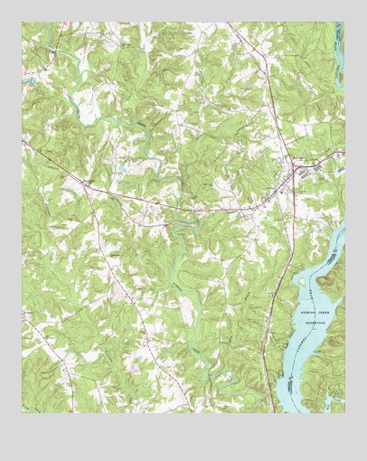
Fort Lawn, SC USGS Topographic Map
Click on map above to begin viewing in our Map Viewer.

This topographic map contains these locations and features:
Feature Name Type Latitude Longitude GNIS ID View Map
Ararat CemeteryCemeteryN34.6871°W80.9798°1220227View Map
Ararat ChurchChurchN34.6938°W80.9634°1220228View Map
Ararat School (historical)SchoolN34.6951°W80.9642°1230623View Map
BascomvillePopulated PlaceN34.6990°W80.9765°1220340View Map
Blakles Caldwells and Strouds CemeteryCemeteryN34.6274°W80.9806°1230633View Map
Cedar Shoals ChurchChurchN34.6757°W80.9659°1247221View Map
Courtney IslandIslandN34.7324°W80.8762°1247404View Map
Dairy BranchStreamN34.6388°W80.9217°1221913View Map
Elmwood CemeteryCemeteryN34.6951°W80.8934°1222273View Map
Fort LawnPopulated PlaceN34.7021°W80.8948°1222502View Map
Fort Lawn Elementary SchoolSchoolN34.6874°W80.8995°1230687View Map
Fort Lawn Fire Department Station 2BuildingN34.6970°W80.8998°2578254View Map
Fort Lawn Police DepartmentBuildingN34.6962°W80.9004°2734247View Map
Fort Lawn Post OfficePost OfficeN34.6974°W80.9006°1252064View Map
Fudges (historical)Populated PlaceN34.7235°W80.9045°1230688View Map
Hopewell CemeteryCemeteryN34.7010°W80.9854°1223283View Map
Howze CemeteryCemeteryN34.6271°W80.9223°1223364View Map
Lake ViewPopulated PlaceN34.6488°W80.8998°1230704View Map
Love-Charity ChurchChurchN34.6493°W80.9909°1246473View Map
McDonalds Ferry (historical)CrossingN34.6515°W80.8881°1241709View Map
McDonalds Ford (historical)CrossingN34.6682°W80.8887°1230719View Map
Mount Nebo ChurchChurchN34.6513°W80.9520°1249611View Map
Mount Prospect ChurchChurchN34.6568°W80.9998°1249671View Map
Mount Vernon ChurchChurchN34.7424°W80.9606°1224808View Map
Nero School (historical)SchoolN34.6504°W80.9517°1230726View Map
Reaves CreekStreamN34.6954°W80.9381°1250297View Map
Rocky Creek WCD Dam Number One D-0212DamN34.6801°W80.9898°1238954View Map
Rossville Fire Department Station 2BuildingN34.6471°W80.9899°2578721View Map
Shepherds Pond D-1437 DamDamN34.7301°W80.9948°1238946View Map
Stroud CemeteryCemeteryN34.6360°W80.9209°1226941View Map
Taylors Island (historical)IslandN34.6607°W80.8876°1230760View Map
Tinkers CreekStreamN34.7174°W80.9584°1227155View Map
Town of Fort LawnCivilN34.7002°W80.8991°2406508View Map
Union Ezella CemeteryCemeteryN34.6982°W80.9251°1227300View Map
Zion Church (historical)ChurchN34.7421°W80.9595°1230778View Map

Note: Coordinates in the location and feature list above are referenced to NAD83 datum.


Copyright (C) 2008-2025 Ryan Niemi / Sunset Dynamics ... All Rights Reserved