TopoQuest Logo
Do you find TopoQuest useful?
Help keep TopoQuest running and adding new maps/features by donating!
Bitcoin:  19c7KJd3qBynnjoSw5npx9KScwjBe4ifkT
Litecoin:  LXs6TkuXGGXo1vDsWCkWVdjQX94eUKd6ui
Home View Maps Find Maps Find Places Resources & Links


Fort Pillow, Tennessee Topographic Map

USGS Map Title: Fort Pillow, TN
USGS Map MRC: 35089F6
DRG (GeoTIFF) Download: o35089f6.tif


Neighboring USGS Topographic Map Quads:


  Rosa, AR  
35089G7
 

  Open Lake, TN  
35089G6
 

  Ripley North, TN  
35089G5
 

  Golddust, TN  
35089F7
 

  Fort Pillow, TN  
35089F6
 

  Ripley South, TN  
35089F5
 

  Gilt Edge, TN  
35089E7
 

  Covington, TN  
35089E6
 

  Gift, TN  
35089E5


Map MRC Location:

N36°
W90°
N36°
W89°
H8 H7 H6 H5 H4 H3 H2 H1
G8 G7 G6 G5 G4 G3 G2 G1
F8 F7 F6 F5 F4 F3 F2 F1
E8 E7 E6 E5 E4 E3 E2 E1
D8 D7 D6 D5 D4 D3 D2 D1
C8 C7 C6 C5 C4 C3 C2 C1
B8 B7 B6 B5 B4 B3 B2 B1
A8 A7 A6 A5 A4 A3 A2 A1
N35°
W90°
N35°
W89°

Fort Pillow, TN USGS 1:24K Topographic Map Preview:
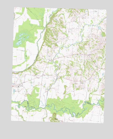
Fort Pillow, TN USGS Topographic Map
Click on map above to begin viewing in our Map Viewer.

This topographic map contains these locations and features:
Feature Name Type Latitude Longitude GNIS ID View Map
Ashport-Three Point Division (historical)CensusN35.6948°W89.6904°1269259View Map
Bee LakeLakeN35.6952°W89.7328°1276776View Map
Bethel ChurchChurchN35.6765°W89.7037°1318068View Map
Boar CreekStreamN35.6484°W89.6492°1277842View Map
Campground CreekStreamN35.6701°W89.6326°1279480View Map
Canaan CemeteryCemeteryN35.6995°W89.6634°1318069View Map
Canaan ChurchChurchN35.6998°W89.6634°1279487View Map
Cane CreekStreamN35.6420°W89.7037°1279514View Map
Cane Creek Number Twenty-two DamDamN35.7317°W89.6351°1302101View Map
Cane Creek Number Twenty-two LakeReservoirN35.7297°W89.6342°1302100View Map
CherryPopulated PlaceN35.6767°W89.7084°1280329View Map
Cherry School (historical)SchoolN35.7090°W89.7170°1318072View Map
Copper Springs CreekStreamN35.6473°W89.6473°1306106View Map
El Canaan ChurchChurchN35.6681°W89.6645°1326527View Map
Elcanaan CemeteryCemeteryN35.6684°W89.6648°1326417View Map
Elcannan School (historical)SchoolN35.6681°W89.6640°1326559View Map
Fort PillowPopulated PlaceN35.6634°W89.7390°1284673View Map
Fort Pillow State FarmLocaleN35.6690°W89.7462°1284674View Map
GlimpPopulated PlaceN35.6995°W89.6445°1285528View Map
Green CemeteryCemeteryN35.6654°W89.7465°1318095View Map
Green ChapelChurchN35.6656°W89.7467°1647456View Map
Johnson Luckett School (historical)SchoolN35.7359°W89.6909°1318105View Map
Lighfoot ChurchChurchN35.7465°W89.6359°1326423View Map
LightfootPopulated PlaceN35.7479°W89.6426°1269728View Map
Lightfoot CemeteryCemeteryN35.7459°W89.6362°1326422View Map
Lightfoot School (historical)SchoolN35.7465°W89.6365°1326424View Map
LuckettPopulated PlaceN35.7281°W89.6745°1315445View Map
Luckett ChurchChurchN35.7248°W89.6748°1326425View Map
Luckett School (historical)SchoolN35.7287°W89.6745°1326426View Map
Lynn School (historical)SchoolN35.7229°W89.6459°1318113View Map
MackPopulated PlaceN35.6690°W89.7437°1647458View Map
Mathis CreekStreamN35.6417°W89.7409°1292935View Map
Millstone MountainSummitN35.6290°W89.6915°1294009View Map
New Hope CemeteryCemeteryN35.6673°W89.7237°1295510View Map
New Hope ChurchChurchN35.6759°W89.7187°1295535View Map
Olive BranchPopulated PlaceN35.7348°W89.6745°1311109View Map
Olive Branch ChurchChurchN35.7362°W89.6679°1296406View Map
Pilgrims Rest CemeteryCemeteryN35.6967°W89.6984°1297472View Map
Pilgrims Rest ChurchChurchN35.6934°W89.7017°1318121View Map
Pleasant HillPopulated PlaceN35.6704°W89.6573°1297845View Map
Ried Dunavant DamDamN35.6784°W89.6267°1302038View Map
Ried Dunavant LakeReservoirN35.6789°W89.6279°1302039View Map
Rosenwald School (historical)SchoolN35.6951°W89.6951°1326429View Map
Round LakeLakeN35.6408°W89.7347°1300160View Map
Saint James CemeteryCemeteryN35.6959°W89.6884°1326430View Map
Saint James ChurchChurchN35.6956°W89.6881°1300439View Map
Sunk LakeLakeN35.7156°W89.7400°1271858View Map
Three PointPopulated PlaceN35.6926°W89.6998°1314401View Map
Town CreekStreamN35.6395°W89.7059°1272805View Map
West Lauderdale County Fire DepartmentBuildingN35.7493°W89.6379°2653884View Map
West Tennessee State PenitentiaryBuildingN35.6711°W89.7474°2765999View Map
Western Valley CemeteryCemeteryN35.6965°W89.6765°1326513View Map

Note: Coordinates in the location and feature list above are referenced to NAD83 datum.


Copyright (C) 2008-2024 Ryan Niemi / Sunset Dynamics ... All Rights Reserved