TopoQuest Logo
Do you find TopoQuest useful?
Help keep TopoQuest running and adding new maps/features by donating!
Bitcoin:  19c7KJd3qBynnjoSw5npx9KScwjBe4ifkT
Litecoin:  LXs6TkuXGGXo1vDsWCkWVdjQX94eUKd6ui
Home View Maps Find Maps Find Places Resources & Links


Open Lake, Tennessee Topographic Map

USGS Map Title: Open Lake, TN
USGS Map MRC: 35089G6
DRG (GeoTIFF) Download: o35089g6.tif


Neighboring USGS Topographic Map Quads:


  Armorel, AR  
35089H7
 

  Chic, TN  
35089H6
 

  Knob Creek, TN  
35089H5
 

  Rosa, AR  
35089G7
 

  Open Lake, TN  
35089G6
 

  Ripley North, TN  
35089G5
 

  Golddust, TN  
35089F7
 

  Fort Pillow, TN  
35089F6
 

  Ripley South, TN  
35089F5


Map MRC Location:

N36°
W90°
N36°
W89°
H8 H7 H6 H5 H4 H3 H2 H1
G8 G7 G6 G5 G4 G3 G2 G1
F8 F7 F6 F5 F4 F3 F2 F1
E8 E7 E6 E5 E4 E3 E2 E1
D8 D7 D6 D5 D4 D3 D2 D1
C8 C7 C6 C5 C4 C3 C2 C1
B8 B7 B6 B5 B4 B3 B2 B1
A8 A7 A6 A5 A4 A3 A2 A1
N35°
W90°
N35°
W89°

Open Lake, TN USGS 1:24K Topographic Map Preview:
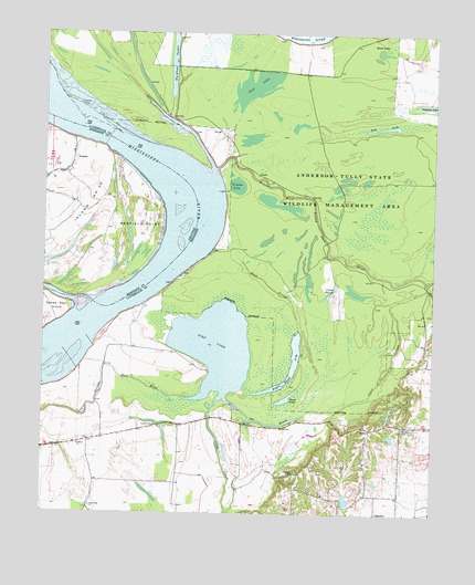
Open Lake, TN USGS Topographic Map
Click on map above to begin viewing in our Map Viewer.

This topographic map contains these locations and features:
Feature Name Type Latitude Longitude GNIS ID View Map
Anderson-Tully State Wildlife Management AreaParkN35.8356°W89.6504°1269303View Map
Ashport CemeteryCemeteryN35.7723°W89.6345°1275949View Map
Ashport ChurchChurchN35.7679°W89.7384°1275951View Map
Barfield PointCapeN35.8237°W89.7206°46087View Map
Bend of Island Number TwentyfiveBendN35.8334°W89.7026°59403View Map
Bend of Island Number Twentyfive RevetmentLeveeN35.8240°W89.6926°1311086View Map
Camp SloughLakeN35.8084°W89.6569°1279410View Map
Cane Creek Number Three DamDamN35.7534°W89.6517°1302114View Map
Cane Creek Number Three LakeReservoirN35.7539°W89.6524°1302113View Map
Cane Ridge ChurchChurchN35.7517°W89.7340°1279541View Map
Cane Ridge School (historical)SchoolN35.7520°W89.7348°1318070View Map
Carr LandingLocaleN35.8501°W89.7481°59400View Map
Chickasaw National Wildlife RefugeParkN35.8423°W89.6610°1320990View Map
Coker SloughStreamN35.7754°W89.6665°1280878View Map
Commissioner District 6CivilN35.8319°W89.6318°2464550View Map
Cypress Hole ChurchChurchN35.7723°W89.7129°1281942View Map
Dry ArmLakeN35.8508°W89.6409°1282818View Map
Forked Deer DikesLeveeN35.7876°W89.7390°1311089View Map
Goose PondLakeN35.7801°W89.6719°1285684View Map
Goses LandingLocaleN35.8729°W89.6659°1318092View Map
Grassy LakeLakeN35.8354°W89.6884°1285904View Map
Island 25 DikesLeveeN35.8337°W89.7134°70088View Map
Island Number 25IslandN35.8248°W89.7426°82451View Map
Island Number Twentysix BarBarN35.8198°W89.7042°1311092View Map
Lassiter BarBarN35.7904°W89.7406°1311101View Map
Lauderdale CountyCivilN35.7610°W89.6314°1639763View Map
Litler LandingLocaleN35.8459°W89.6998°1318111View Map
Lost LakeLakeN35.8613°W89.6828°1292086View Map
Middle Fork Forked Deer RiverStreamN35.8401°W89.6954°1293672View Map
Obion-Tamm RevetmentLeveeN35.8729°W89.6681°1311108View Map
Open LakeLakeN35.7936°W89.6949°1296448View Map
Right Hand ArmLakeN35.7831°W89.6746°1299438View Map
Rush SloughStreamN35.7979°W89.6681°1300269View Map
Swan LakeLakeN35.8704°W89.6421°1271942View Map
The ReachChannelN35.7731°W89.6770°1272434View Map
TomatoPopulated PlaceN35.8437°W89.7412°78571View Map
Tomato LandingLocaleN35.8479°W89.7406°59402View Map
Wardlows PocketLakeN35.8687°W89.7093°1273802View Map
Wardlows Pocket LandingLocaleN35.8501°W89.7126°1318137View Map

Note: Coordinates in the location and feature list above are referenced to NAD83 datum.


Copyright (C) 2008-2024 Ryan Niemi / Sunset Dynamics ... All Rights Reserved