TopoQuest Logo
Do you find TopoQuest useful?
Help keep TopoQuest running and adding new maps/features by donating!
Bitcoin:  19c7KJd3qBynnjoSw5npx9KScwjBe4ifkT
Litecoin:  LXs6TkuXGGXo1vDsWCkWVdjQX94eUKd6ui
Home View Maps Find Maps Find Places Resources & Links


Gift, Tennessee Topographic Map

USGS Map Title: Gift, TN
USGS Map MRC: 35089E5
DRG (GeoTIFF) Download: o35089e5.tif


Neighboring USGS Topographic Map Quads:


  Fort Pillow, TN  
35089F6
 

  Ripley South, TN  
35089F5
 

  Durhamville, TN  
35089F4
 

  Covington, TN  
35089E6
 

  Gift, TN  
35089E5
 

  Turnpike, TN  
35089E4
 

  Brighton, TN  
35089D6
 

  Mason, TN  
35089D5
 

  Stanton, TN  
35089D4


Map MRC Location:

N36°
W90°
N36°
W89°
H8 H7 H6 H5 H4 H3 H2 H1
G8 G7 G6 G5 G4 G3 G2 G1
F8 F7 F6 F5 F4 F3 F2 F1
E8 E7 E6 E5 E4 E3 E2 E1
D8 D7 D6 D5 D4 D3 D2 D1
C8 C7 C6 C5 C4 C3 C2 C1
B8 B7 B6 B5 B4 B3 B2 B1
A8 A7 A6 A5 A4 A3 A2 A1
N35°
W90°
N35°
W89°

Gift, TN USGS 1:24K Topographic Map Preview:
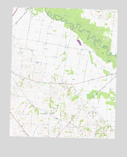
Gift, TN USGS Topographic Map
Click on map above to begin viewing in our Map Viewer.

This topographic map contains these locations and features:
Feature Name Type Latitude Longitude GNIS ID View Map
AntiochPopulated PlaceN35.5859°W89.5426°1314588View Map
Antioch Church (historical)ChurchN35.5862°W89.5423°1317101View Map
Antioch School (historical)SchoolN35.5865°W89.5431°1317102View Map
Brigmon BranchStreamN35.5312°W89.5642°1278392View Map
Cane CreekStreamN35.5579°W89.5112°1279505View Map
Church of Christ (historical)ChurchN35.5845°W89.6076°1326431View Map
Commissioner District 1CivilN35.5915°W89.6163°2464289View Map
Commissioner District 2CivilN35.5158°W89.5572°2463977View Map
Cotton CemeteryCemeteryN35.5251°W89.5328°1281353View Map
Cotton LakeLakeN35.5753°W89.5108°1281361View Map
Cotton LakePopulated PlaceN35.5620°W89.5054°1281362View Map
Cotton Lake Church (historical)ChurchN35.5626°W89.5054°1317123View Map
Cotton Lake School (historical)SchoolN35.5617°W89.5054°1326556View Map
Covington Municipal AirportAirportN35.5884°W89.5846°1301351View Map
Flat CreekStreamN35.6104°W89.5584°1284375View Map
GiftPopulated PlaceN35.5523°W89.5645°1285364View Map
Hebron ChurchChurchN35.5812°W89.6134°1287309View Map
Hogpen SloughGutN35.5845°W89.5198°1288014View Map
Lagoon CreekStreamN35.5809°W89.5017°1290474View Map
Marrows CemeteryCemeteryN35.6190°W89.5217°1292730View Map
Pleasant Grove ChurchChurchN35.5051°W89.6079°1297819View Map
Plumer Grove School (historical)SchoolN35.5779°W89.5715°1317183View Map
Plummers Grove ChurchChurchN35.5773°W89.5715°1297983View Map
RialtoPopulated PlaceN35.6240°W89.6073°1299289View Map
Rialto Industrial ParkLocaleN35.6226°W89.6176°1317191View Map
Rialto School (historical)SchoolN35.6156°W89.6029°1326558View Map
Richland CreekStreamN35.6051°W89.5531°1299357View Map
Saint Luke ChurchChurchN35.5217°W89.5492°1300462View Map
Sharps CemeteryCemeteryN35.5092°W89.5820°1301278View Map
Shiloh ChurchChurchN35.5287°W89.5729°1303580View Map
SoloPopulated PlaceN35.5840°W89.5998°1270806View Map
Steven ChapelChurchN35.6165°W89.6026°1326507View Map
TabernaclePopulated PlaceN35.5226°W89.5770°1272023View Map
Tabernacle Division (historical)CensusN35.5131°W89.5231°1648984View Map
Tabernacle Lookout TowerTowerN35.5106°W89.5459°1647755View Map
Tabernacle SchoolSchoolN35.5184°W89.5692°1272026View Map
Thurmond Glenn Field (historical)AirportN35.5570°W89.5529°1301348View Map
Tipton CemeteryCemeteryN35.5548°W89.6112°1272680View Map
Walnut Corner ChurchChurchN35.5870°W89.5579°1273709View Map
Willow Grove ChurchChurchN35.6004°W89.5826°1274760View Map

Note: Coordinates in the location and feature list above are referenced to NAD83 datum.


Copyright (C) 2008-2025 Ryan Niemi / Sunset Dynamics ... All Rights Reserved