TopoQuest Logo
Do you find TopoQuest useful?
Help keep TopoQuest running and adding new maps/features by donating!
Bitcoin:  19c7KJd3qBynnjoSw5npx9KScwjBe4ifkT
Litecoin:  LXs6TkuXGGXo1vDsWCkWVdjQX94eUKd6ui
Home View Maps Find Maps Find Places Resources & Links


Ripley North, Tennessee Topographic Map

USGS Map Title: Ripley North, TN
USGS Map MRC: 35089G5
DRG (GeoTIFF) Download: o35089g5.tif


Neighboring USGS Topographic Map Quads:


  Chic, TN  
35089H6
 

  Knob Creek, TN  
35089H5
 

  Fowlkes, TN  
35089H4
 

  Open Lake, TN  
35089G6
 

  Ripley North, TN  
35089G5
 

  Gates, TN  
35089G4
 

  Fort Pillow, TN  
35089F6
 

  Ripley South, TN  
35089F5
 

  Durhamville, TN  
35089F4


Map MRC Location:

N36°
W90°
N36°
W89°
H8 H7 H6 H5 H4 H3 H2 H1
G8 G7 G6 G5 G4 G3 G2 G1
F8 F7 F6 F5 F4 F3 F2 F1
E8 E7 E6 E5 E4 E3 E2 E1
D8 D7 D6 D5 D4 D3 D2 D1
C8 C7 C6 C5 C4 C3 C2 C1
B8 B7 B6 B5 B4 B3 B2 B1
A8 A7 A6 A5 A4 A3 A2 A1
N35°
W90°
N35°
W89°

Ripley North, TN USGS 1:24K Topographic Map Preview:
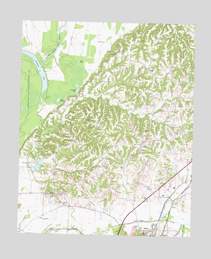
Ripley North, TN USGS Topographic Map
Click on map above to begin viewing in our Map Viewer.

This topographic map contains these locations and features:
Feature Name Type Latitude Longitude GNIS ID View Map
ArpPopulated PlaceN35.7734°W89.6026°1275902View Map
Arp SchoolSchoolN35.7681°W89.5917°1275903View Map
Bill Smith LakeReservoirN35.7978°W89.5255°1302142View Map
Bill Smith Lake DamDamN35.7984°W89.5251°1302143View Map
Cane Creek Dam Number NineDamN35.7917°W89.5117°1302136View Map
Cane Creek Lake Number NineReservoirN35.7922°W89.5122°1302135View Map
Cane Creek Number Five DamDamN35.7601°W89.6201°1302115View Map
Cane Creek Number Five LakeReservoirN35.7601°W89.6201°1302116View Map
CentralPopulated PlaceN35.8037°W89.5373°1280160View Map
Central ChurchChurchN35.8117°W89.5342°1280161View Map
Central School (historical)SchoolN35.8037°W89.5381°1318071View Map
Chisholm LakeLakeN35.8490°W89.6133°1269458View Map
Cold CreekStreamN35.8287°W89.6115°1275389View Map
EdithPopulated PlaceN35.8484°W89.5331°1283531View Map
Edith School (historical)SchoolN35.8448°W89.5298°1318080View Map
Fain Spring CreekStreamN35.7570°W89.5067°1283966View Map
Flying I Ranch AirportAirportN35.7616°W89.5514°1301365View Map
Grace ChurchChurchN35.8004°W89.5367°1318093View Map
Gray School (historical)SchoolN35.8079°W89.5879°1318094View Map
Gum PondLakeN35.8288°W89.5977°1286409View Map
Hyde CreekStreamN35.7512°W89.5670°1288884View Map
Jennings PondLakeN35.8344°W89.5842°1289385View Map
King CreekStreamN35.8206°W89.5348°1311100View Map
Lauderdale County Ambulance AuthorityBuildingN35.7651°W89.5430°2697416View Map
Long PondLakeN35.8519°W89.5834°1291995View Map
Macedonia ChurchChurchN35.8451°W89.5298°1318114View Map
Matthews School (historical)SchoolN35.7601°W89.6065°1318115View Map
Mount Pleasant CemeteryCemeteryN35.7723°W89.5976°1318116View Map
Mount Pleasant ChurchChurchN35.7731°W89.5970°1318117View Map
Nelson CreekStreamN35.7595°W89.5223°1295381View Map
New Hope CemeteryCemeteryN35.7970°W89.5448°1295511View Map
New Hope ChurchChurchN35.8020°W89.5373°1318120View Map
Northwest Lauderdale County Fire DepartmentBuildingN35.8042°W89.5383°2653883View Map
Old Bed Forked Deer RiverStreamN35.8481°W89.6109°1296269View Map
Pleasant Grove CemeteryCemeteryN35.8481°W89.5359°1318122View Map
Ripley ChurchChurchN35.7720°W89.5334°1299472View Map
Ripley Division (historical)CensusN35.7506°W89.5365°1648817View Map
Saint Matthew ChurchChurchN35.7587°W89.6065°1300485View Map
Separate Pond (historical)LakeN35.8212°W89.6095°1311114View Map
Tennessee Department of Agriculture Division of Forestry Ripley Fire TowerBuildingN35.8498°W89.5178°2653913View Map
Walnut Grove CemeteryCemeteryN35.7917°W89.6181°1318136View Map
Walnut Grove ChurchChurchN35.7912°W89.6184°1304353View Map

Note: Coordinates in the location and feature list above are referenced to NAD83 datum.


Copyright (C) 2008-2024 Ryan Niemi / Sunset Dynamics ... All Rights Reserved