TopoQuest Logo
Do you find TopoQuest useful?
Help keep TopoQuest running and adding new maps/features by donating!
Bitcoin:  19c7KJd3qBynnjoSw5npx9KScwjBe4ifkT
Litecoin:  LXs6TkuXGGXo1vDsWCkWVdjQX94eUKd6ui
Home View Maps Find Maps Find Places Resources & Links


Fort Seward, California Topographic Map

USGS Map Title: Fort Seward, CA
USGS Map MRC: 40123B6
DRG (GeoTIFF) Download: o40123b6.tif


Neighboring USGS Topographic Map Quads:


  Myers Flat, CA  
40123C7
 

  Blocksburg, CA  
40123C6
 

  Black Lassic, CA  
40123C5
 

  Miranda, CA  
40123B7
 

  Fort Seward, CA  
40123B6
 

  Alderpoint, CA  
40123B5
 

  Garberville, CA  
40123A7
 

  Harris, CA  
40123A6
 

  Jewett Rock, CA  
40123A5


Map MRC Location:

N41°
W124°
N41°
W123°
H8 H7 H6 H5 H4 H3 H2 H1
G8 G7 G6 G5 G4 G3 G2 G1
F8 F7 F6 F5 F4 F3 F2 F1
E8 E7 E6 E5 E4 E3 E2 E1
D8 D7 D6 D5 D4 D3 D2 D1
C8 C7 C6 C5 C4 C3 C2 C1
B8 B7 B6 B5 B4 B3 B2 B1
A8 A7 A6 A5 A4 A3 A2 A1
N40°
W124°
N40°
W123°

Fort Seward, CA USGS 1:24K Topographic Map Preview:
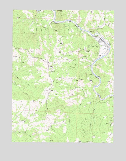
Fort Seward, CA USGS Topographic Map
Click on map above to begin viewing in our Map Viewer.

This topographic map contains these locations and features:
Feature Name Type Latitude Longitude GNIS ID View Map
Big SpringSpringN40.1751°W123.7317°219265View Map
Boehne ButteSummitN40.2301°W123.6523°219582View Map
Brock CreekStreamN40.2488°W123.7195°219865View Map
Brock Creek (historical)Populated PlaceN40.2479°W123.7161°1665526View Map
Conley CreekStreamN40.2374°W123.6398°266592View Map
Dobbyn CreekStreamN40.2301°W123.6586°259419View Map
Fort SewardPopulated PlaceN40.2229°W123.6434°223709View Map
Hamner FlatFlatN40.1982°W123.6495°224860View Map
Helmke SpringSpringN40.1816°W123.6948°225153View Map
Hole in the GroundFlatN40.1746°W123.6706°225443View Map
Hubbard StationLocaleN40.2138°W123.7459°225721View Map
Huestis RockPillarN40.2038°W123.7167°225730View Map
Hurlbutt RanchLocaleN40.1451°W123.7367°225804View Map
Jackass CreekStreamN40.2013°W123.6500°254834View Map
Line GulchValleyN40.2343°W123.6253°234161View Map
Middle RidgeRidgeN40.2024°W123.6825°228616View Map
Ort CreekStreamN40.2390°W123.6998°230116View Map
Pepperwood SpringsSpringN40.1915°W123.7038°230519View Map
Powers CreekStreamN40.1679°W123.6475°231019View Map
Soda CreekStreamN40.1988°W123.6531°253907View Map
SteelheadPopulated PlaceN40.1701°W123.6453°1656332View Map
Steelhead CreekStreamN40.1713°W123.6470°253930View Map
Tuttle ButtesSummitN40.1621°W123.7159°1656373View Map
Wildcat ButteSummitN40.2310°W123.6956°237771View Map
Willow Draw CreekStreamN40.2396°W123.6831°237910View Map
Winchester RidgeRidgeN40.1854°W123.6764°238003View Map
Woods MineMineN40.2046°W123.7050°238160View Map
Yellow Jacket ButteSummitN40.2493°W123.6892°1656415View Map

Note: Coordinates in the location and feature list above are referenced to NAD83 datum.


Copyright (C) 2008-2024 Ryan Niemi / Sunset Dynamics ... All Rights Reserved