TopoQuest Logo
Do you find TopoQuest useful?
Help keep TopoQuest running and adding new maps/features by donating!
Bitcoin:  19c7KJd3qBynnjoSw5npx9KScwjBe4ifkT
Litecoin:  LXs6TkuXGGXo1vDsWCkWVdjQX94eUKd6ui
Home View Maps Find Maps Find Places Resources & Links


Fossil Canyon, Idaho Topographic Map

USGS Map Title: Fossil Canyon, ID
USGS Map MRC: 42111E4
DRG (GeoTIFF) Download: o42111e4.tif


Neighboring USGS Topographic Map Quads:


  Soda Springs, ID  
42111F5
 

  Johnson Creek, ID  
42111F4
 

  Dry Valley, ID  
42111F3
 

  Soda Peak, ID  
42111E5
 

  Fossil Canyon, ID  
42111E4
 

  Harrington Peak, ID  
42111E3
 

  North Canyon, ID  
42111D5
 

  Nounan, ID  
42111D4
 

  Georgetown, ID  
42111D3


Map MRC Location:

N43°
W112°
N43°
W111°
H8 H7 H6 H5 H4 H3 H2 H1
G8 G7 G6 G5 G4 G3 G2 G1
F8 F7 F6 F5 F4 F3 F2 F1
E8 E7 E6 E5 E4 E3 E2 E1
D8 D7 D6 D5 D4 D3 D2 D1
C8 C7 C6 C5 C4 C3 C2 C1
B8 B7 B6 B5 B4 B3 B2 B1
A8 A7 A6 A5 A4 A3 A2 A1
N42°
W112°
N42°
W111°

Fossil Canyon, ID USGS 1:24K Topographic Map Preview:
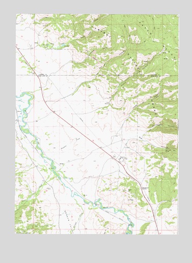
Fossil Canyon, ID USGS Topographic Map
Click on map above to begin viewing in our Map Viewer.

This topographic map contains these locations and features:
Feature Name Type Latitude Longitude GNIS ID View Map
Bear Lake ValleyValleyN42.5016°W111.4177°377177View Map
Big CanyonValleyN42.5510°W111.4155°377452View Map
Big Canyon SpringSpringN42.5484°W111.3852°377460View Map
Cavanaugh SidingLocaleN42.5205°W111.4474°394845View Map
Cranes ReservoirReservoirN42.5741°W111.4278°380037View Map
Diamond GulchValleyN42.5805°W111.4899°380573View Map
Dry CanyonValleyN42.5741°W111.4727°380785View Map
Fossil CanyonValleyN42.5688°W111.4463°381950View Map
Georgetown SummitGapN42.5249°W111.4152°382248View Map
Georgetown Summit Wildlife Management AreaReserveN42.5613°W111.4069°401369View Map
Jones CanyonValleyN42.5585°W111.4219°384010View Map
Lakey ReservoirReservoirN42.6073°W111.4638°384392View Map
MansonPopulated PlaceN42.5696°W111.4988°396849View Map
Ninemile CreekStreamN42.5424°W111.4730°387572View Map
Nounan ValleyValleyN42.5260°W111.4599°387874View Map
Pearl CreekStreamN42.5330°W111.4674°388304View Map
Rattlesnake CanyonValleyN42.5563°W111.4030°389133View Map
Skinner CreekStreamN42.5213°W111.4549°390522View Map
Stewart Ranch DamDamN42.5549°W111.4291°398967View Map
Swan LakeLakeN42.6073°W111.4750°391720View Map
Swan Lake GulchValleyN42.6069°W111.4713°391726View Map
Swan LakesLakeN42.6072°W111.4728°391719View Map

Note: Coordinates in the location and feature list above are referenced to NAD83 datum.


Copyright (C) 2008-2025 Ryan Niemi / Sunset Dynamics ... All Rights Reserved