TopoQuest Logo
Do you find TopoQuest useful?
Help keep TopoQuest running and adding new maps/features by donating!
Bitcoin:  19c7KJd3qBynnjoSw5npx9KScwjBe4ifkT
Litecoin:  LXs6TkuXGGXo1vDsWCkWVdjQX94eUKd6ui
Home View Maps Find Maps Find Places Resources & Links


Romulus, Alabama Topographic Map

USGS Map Title: Romulus, AL
USGS Map MRC: 33087B7
DRG (GeoTIFF) Download: o33087b7.tif


Neighboring USGS Topographic Map Quads:


  Gordo, AL  
33087C8
 

  Elrod, AL  
33087C7
 

  Lake Lurleen, AL  
33087C6
 

  Kirk, AL  
33087B8
 

  Romulus, AL  
33087B7
 

  Coker, AL  
33087B6
 

  Mantua, AL  
33087A8
 

  Ralph, AL  
33087A7
 

  Fosters, AL  
33087A6


Map MRC Location:

N34°
W88°
N34°
W87°
H8 H7 H6 H5 H4 H3 H2 H1
G8 G7 G6 G5 G4 G3 G2 G1
F8 F7 F6 F5 F4 F3 F2 F1
E8 E7 E6 E5 E4 E3 E2 E1
D8 D7 D6 D5 D4 D3 D2 D1
C8 C7 C6 C5 C4 C3 C2 C1
B8 B7 B6 B5 B4 B3 B2 B1
A8 A7 A6 A5 A4 A3 A2 A1
N33°
W88°
N33°
W87°

Romulus, AL USGS 1:24K Topographic Map Preview:
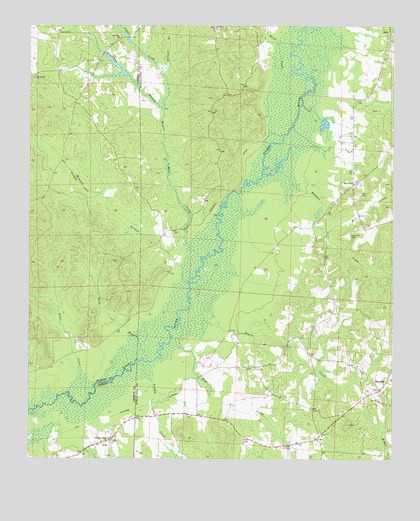
Romulus, AL USGS Topographic Map
Click on map above to begin viewing in our Map Viewer.

This topographic map contains these locations and features:
Feature Name Type Latitude Longitude GNIS ID View Map
Allen CreekStreamN33.1443°W87.8606°113007View Map
Backbone CemeteryCemeteryN33.2493°W87.8103°147828View Map
Beaver Dam ChurchChurchN33.1860°W87.8192°147843View Map
Beaverdam BranchStreamN33.2260°W87.8308°113755View Map
Buhl Church of GodChurchN33.2051°W87.7645°115169View Map
Caledonia CemeteryCemeteryN33.1907°W87.7645°155004View Map
Dillard BranchStreamN33.2376°W87.8311°117284View Map
Dry CreekStreamN33.1632°W87.8225°117572View Map
Elledge BranchStreamN33.2493°W87.8445°117937View Map
Elrod ChurchChurchN33.2498°W87.8133°117964View Map
Elrod CreekStreamN33.2365°W87.7856°117965View Map
Engine CreekStreamN33.1643°W87.8236°117988View Map
Fifes Shop (historical)LocaleN33.2279°W87.8586°135518View Map
Flatwood CemeteryCemeteryN33.2484°W87.8647°158604View Map
Flatwood ChurchChurchN33.2482°W87.8656°118403View Map
Gilliam FarmsLocaleN33.1433°W87.7628°2702821View Map
Gregorys FordCrossingN33.1446°W87.8520°132565View Map
Hammer CreekStreamN33.2082°W87.7906°158840View Map
Huffmans FordCrossingN33.1473°W87.8475°132589View Map
JenaPopulated PlaceN33.1307°W87.8470°120838View Map
Jena School (historical)SchoolN33.1290°W87.8464°132592View Map
Jordan CemeteryCemeteryN33.2096°W87.8433°135551View Map
Leavelle FarmsLocaleN33.1489°W87.8017°2702822View Map
Logan CreekStreamN33.2376°W87.8311°152141View Map
Malone Mill CreekStreamN33.1835°W87.8170°152213View Map
Marquis (historical)LocaleN33.1793°W87.8661°135567View Map
McAteer BranchStreamN33.1760°W87.8217°122447View Map
Mill CreekStreamN33.1907°W87.7728°122770View Map
Mount Bethel ChurchChurchN33.2351°W87.8734°123148View Map
Mount Olive CemeteryCemeteryN33.2476°W87.8445°158612View Map
Mount Olive ChurchChurchN33.2473°W87.8453°152462View Map
New Hope Baptist ChurchChurchN33.1421°W87.7539°152639View Map
New Hope CemeteryCemeteryN33.1412°W87.7539°148366View Map
Pate CemeteryCemeteryN33.2018°W87.7617°124470View Map
Pates Bridge (historical)BridgeN33.1807°W87.8156°148428View Map
Pleasant Grove CemeteryCemeteryN33.1309°W87.8475°154142View Map
Pleasant Grove Methodist ChurchChurchN33.1310°W87.8475°152978View Map
RaleighLocaleN33.2162°W87.8622°135612View Map
RomulusPopulated PlaceN33.1476°W87.7520°156993View Map
Romulus CemeteryCemeteryN33.1498°W87.7600°148501View Map
Romulus Methodist ChurchChurchN33.1504°W87.7600°148500View Map
Romulus Volunteer Fire DepartmentBuildingN33.1479°W87.7515°2683422View Map
Sipsey River Hunting ClubLocaleN33.1257°W87.8614°132705View Map
Sipsey SwampSwampN33.2300°W87.7884°148557View Map
Turkey CreekStreamN33.1518°W87.8392°128166View Map
Turkey FordCrossingN33.1404°W87.8675°132730View Map
Webb BranchStreamN33.1537°W87.8353°128680View Map
Zion Church (historical)ChurchN33.2021°W87.8397°135649View Map

Note: Coordinates in the location and feature list above are referenced to NAD83 datum.


Copyright (C) 2008-2024 Ryan Niemi / Sunset Dynamics ... All Rights Reserved