TopoQuest Logo
Do you find TopoQuest useful?
Help keep TopoQuest running and adding new maps/features by donating!
Bitcoin:  19c7KJd3qBynnjoSw5npx9KScwjBe4ifkT
Litecoin:  LXs6TkuXGGXo1vDsWCkWVdjQX94eUKd6ui
Home View Maps Find Maps Find Places Resources & Links


Franklin, Wisconsin Topographic Map

USGS Map Title: Franklin, WI
USGS Map MRC: 43087G8
DRG (GeoTIFF) Download: o43087g8.tif


Neighboring USGS Topographic Map Quads:


  Kiel, WI  
43088H1
 

  School Hill, WI  
43087H8
 

  Cleveland West, WI  
43087H7
 

  Elkhart Lake, WI  
43088G1
 

  Franklin, WI  
43087G8
 

  Howards Grove, WI  
43087G7
 

  Cascade, WI  
43088F1
 

  Plymouth South, WI  
43087F8
 

  Sheboygan Falls, WI  
43087F7


Map MRC Location:

N44°
W88°
N44°
W87°
H8 H7 H6 H5 H4 H3 H2 H1
G8 G7 G6 G5 G4 G3 G2 G1
F8 F7 F6 F5 F4 F3 F2 F1
E8 E7 E6 E5 E4 E3 E2 E1
D8 D7 D6 D5 D4 D3 D2 D1
C8 C7 C6 C5 C4 C3 C2 C1
B8 B7 B6 B5 B4 B3 B2 B1
A8 A7 A6 A5 A4 A3 A2 A1
N43°
W88°
N43°
W87°

Franklin, WI USGS 1:24K Topographic Map Preview:
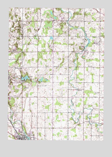
Franklin, WI USGS Topographic Map
Click on map above to begin viewing in our Map Viewer.

This topographic map contains these locations and features:
Feature Name Type Latitude Longitude GNIS ID View Map
A M Krueger HallBuildingN43.8422°W87.8826°1956892View Map
Acorn SchoolSchoolN43.7767°W87.9209°1560678View Map
Arnhoelter DairyLocaleN43.8636°W87.8986°2706301View Map
Birch PointCapeN43.8075°W87.9790°1561815View Map
Bradley BuildingBuildingN43.8422°W87.8843°1956893View Map
Bullet LakeLakeN43.8068°W87.9499°1577353View Map
Camp AnokijigLocaleN43.8072°W87.9709°1562577View Map
Cen Mer Dairy FarmLocaleN43.8536°W87.9003°2706302View Map
Chase CenterBuildingN43.8422°W87.8856°1956894View Map
Cleveland School (historical)SchoolN43.7958°W87.8812°1563184View Map
Doar ChurchChurchN43.8125°W87.9409°1564011View Map
Dollar LakeLakeN43.8657°W87.9396°2761678View Map
Elkhart Lake CemeteryCemeteryN43.8334°W87.9958°1564531View Map
Esch LibraryBuildingN43.8414°W87.8831°1956898View Map
Fairview Elementary SchoolSchoolN43.7502°W87.9642°1834546View Map
Faith Christian AcademySchoolN43.7605°W87.9858°2716761View Map
Feldmann Field (historical)AirportN43.8042°W87.8973°1582203View Map
First Evangelical United Brethren Church (historical)ChurchN43.7503°W87.9840°1834559View Map
FranklinPopulated PlaceN43.8355°W87.9015°1565252View Map
Franklin DamDamN43.8367°W87.9001°1792042View Map
Franklin Pond 170ReservoirN43.8367°W87.9001°1792043View Map
Franklin School (historical)SchoolN43.8480°W87.8904°1565271View Map
Franklin Volunteer Fire DepartmentBuildingN43.8358°W87.9024°2697799View Map
Friedli HallBuildingN43.8433°W87.8840°1956899View Map
Gerber LakeLakeN43.8071°W87.9571°1565473View Map
Grant School (historical)SchoolN43.7908°W87.9620°1565745View Map
Grether Natural LaboratoryLocaleN43.8425°W87.8898°1956902View Map
Grosshuesch HallBuildingN43.8400°W87.8851°1956903View Map
Hofer HallBuildingN43.8433°W87.8834°1956900View Map
Immanuel United Church of ChristChurchN43.8489°W87.8806°1566872View Map
Jackson CreekStreamN43.7658°W87.9929°1567068View Map
JohnsonvillePopulated PlaceN43.7983°W87.9095°1567252View Map
Johnsonville Fire DepartmentBuildingN43.7985°W87.9104°2698176View Map
Johnsonville PondReservoirN43.7995°W87.9108°2761679View Map
Lakeland CollegeSchoolN43.8412°W87.8820°1569610View Map
Laun CenterBuildingN43.8417°W87.8843°1956904View Map
Ley ChapelChurchN43.8422°W87.8862°1956905View Map
Liberty CemeteryCemeteryN43.8335°W87.9316°1568011View Map
Little Elkhart LakeLakeN43.8083°W87.9780°1568255View Map
Little Elkhart Lake School (historical)SchoolN43.8180°W87.9845°1568256View Map
Maeuser FarmLocaleN43.8594°W87.9136°2706307View Map
Maple Grove CemeteryCemeteryN43.7850°W87.9633°1568973View Map
Mill PondLakeN43.7522°W87.9715°1569485View Map
Miller CemeteryCemeteryN43.8252°W87.9822°1569510View Map
Muelhmeier HallBuildingN43.8400°W87.8837°1956906View Map
Nash CenterBuildingN43.8419°W87.8818°1956907View Map
North Industrial ParkLocaleN43.7736°W87.9987°1834630View Map
Old Main HallBuildingN43.8417°W87.8826°1956908View Map
Otter CreekStreamN43.7883°W87.9179°1577415View Map
Parkview Elementary SchoolSchoolN43.7547°W87.9904°1834642View Map
Pinehurst School (historical)SchoolN43.8197°W87.8904°1571529View Map
Plymouth Millpond 58.6ReservoirN43.7512°W87.9723°1792844View Map
Plymouth Volunteer Fire Department Station 2BuildingN43.7571°W87.9836°2697543View Map
RhinePopulated PlaceN43.8628°W87.9568°1572230View Map
Rhine Boarder FarmLocaleN43.8322°W87.9328°2706309View Map
Rhine Center Bog State Natural AreaParkN43.8703°W87.9444°2082076View Map
Rhinestone FarmsLocaleN43.8561°W87.9603°2706306View Map
Riverview Middle SchoolSchoolN43.7558°W87.9790°1834658View Map
Road America RacewayLocaleN43.7975°W87.9940°1581332View Map
Rocky Knoll SanatoriumHospitalN43.7989°W87.9781°1572503View Map
Romar FarmsLocaleN43.8369°W87.9639°2706310View Map
Saint George CemeteryCemeteryN43.8481°W87.9817°1572949View Map
Saint John CemeteryCemeteryN43.7576°W87.9801°1573001View Map
Saint John ChurchChurchN43.8486°W87.9654°1573012View Map
Saint Peter Evangelical CemeteryCemeteryN43.8488°W87.9659°1833476View Map
Salem Evangelical and Reformed Church (historical)ChurchN43.7522°W87.9781°1834689View Map
Saron CemeteryCemeteryN43.7921°W87.8884°1833486View Map
Saron ChurchChurchN43.7914°W87.8873°1573727View Map
Schuett CreekStreamN43.8569°W87.9159°1577412View Map
Sheboygan County FairgroundsLocaleN43.7514°W87.9679°1834702View Map
Taylor FieldParkN43.8436°W87.8876°1956912View Map
Town of PlymouthCivilN43.7639°W87.9839°1583948View Map
Town of RhineCivilN43.8488°W87.9804°1584013View Map
Turner HallBuildingN43.7503°W87.9770°1834728View Map
Union CemeteryCemeteryN43.7511°W87.9757°1577246View Map
Victory School (historical)SchoolN43.8197°W87.9406°1576089View Map
Vorhulst HallBuildingN43.8422°W87.8834°1956909View Map
W A Krueger HallBuildingN43.8411°W87.8820°1956910View Map
Wehr CenterBuildingN43.8436°W87.8865°1956911View Map
Zoar Salem CemeteryCemeteryN43.8125°W87.9413°1833490View Map

Note: Coordinates in the location and feature list above are referenced to NAD83 datum.


Copyright (C) 2008-2025 Ryan Niemi / Sunset Dynamics ... All Rights Reserved