TopoQuest Logo
Do you find TopoQuest useful?
Help keep TopoQuest running and adding new maps/features by donating!
Bitcoin:  19c7KJd3qBynnjoSw5npx9KScwjBe4ifkT
Litecoin:  LXs6TkuXGGXo1vDsWCkWVdjQX94eUKd6ui
Home View Maps Find Maps Find Places Resources & Links


Plymouth South, Wisconsin Topographic Map

USGS Map Title: Plymouth South, WI
USGS Map MRC: 43087F8
DRG (GeoTIFF) Download: o43087f8.tif


Neighboring USGS Topographic Map Quads:


  Elkhart Lake, WI  
43088G1
 

  Franklin, WI  
43087G8
 

  Howards Grove, WI  
43087G7
 

  Cascade, WI  
43088F1
 

  Plymouth South, WI  
43087F8
 

  Sheboygan Falls, WI  
43087F7
 

  Batavia, WI  
43088E1
 

  Random Lake, WI  
43087E8
 

  Cedar Grove, WI  
43087E7


Map MRC Location:

N44°
W88°
N44°
W87°
H8 H7 H6 H5 H4 H3 H2 H1
G8 G7 G6 G5 G4 G3 G2 G1
F8 F7 F6 F5 F4 F3 F2 F1
E8 E7 E6 E5 E4 E3 E2 E1
D8 D7 D6 D5 D4 D3 D2 D1
C8 C7 C6 C5 C4 C3 C2 C1
B8 B7 B6 B5 B4 B3 B2 B1
A8 A7 A6 A5 A4 A3 A2 A1
N43°
W88°
N43°
W87°

Plymouth South, WI USGS 1:24K Topographic Map Preview:
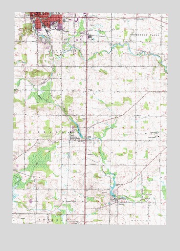
Plymouth South, WI USGS Topographic Map
Click on map above to begin viewing in our Map Viewer.

This topographic map contains these locations and features:
Feature Name Type Latitude Longitude GNIS ID View Map
72 ReservoirReservoirN43.7350°W87.9768°1792253View Map
Aurora Surgery CenterHospitalN43.7436°W87.9693°1834733View Map
Banner School (historical)SchoolN43.6672°W87.9012°1834507View Map
Bonnie View School (historical)SchoolN43.7186°W87.9209°1834517View Map
Brickbauer DamDamN43.7350°W87.9768°1792252View Map
Camp RiversiteLocaleN43.6433°W87.8923°1562652View Map
Cascade SwampSwampN43.6567°W87.9865°1562760View Map
City of PlymouthCivilN43.7453°W87.9654°1583947View Map
Eagles HallBuildingN43.7483°W87.9731°1834539View Map
Evergreen CemeteryCemeteryN43.7041°W87.9361°1566069View Map
Farmin CemeteryCemeteryN43.7036°W87.8804°1564866View Map
First Church of Christ ScientistChurchN43.7494°W87.9787°1834555View Map
First Congregational ChurchChurchN43.7489°W87.9840°1834557View Map
Harmon School (historical)SchoolN43.7036°W87.9404°1834578View Map
HinghamPopulated PlaceN43.6389°W87.9143°1566481View Map
Hingham CemeteryCemeteryN43.6351°W87.9155°1833474View Map
Hingham Census Designated PlaceCensusN43.6464°W87.9151°2586504View Map
Hingham DamDamN43.6417°W87.9162°1792250View Map
Hingham Mill PondReservoirN43.6429°W87.9187°1566482View Map
Holden School (historical)SchoolN43.7261°W87.8809°1834582View Map
Horizon Elementary SchoolSchoolN43.7408°W87.9596°2716670View Map
Huson ParkParkN43.7464°W87.9743°1566831View Map
Lyceum HallBuildingN43.7483°W87.9781°1834615View Map
Lyndon CemeteryCemeteryN43.6459°W87.9403°1568841View Map
Meyer ParkParkN43.7425°W87.9856°1569392View Map
Mulleton Church (historical)ChurchN43.7172°W87.9415°1834625View Map
New ParisPopulated PlaceN43.7331°W87.9720°1577746View Map
Nutt ParkParkN43.7497°W87.9893°1570580View Map
Onion River DamDamN43.6767°W87.9451°1792256View Map
PlymouthPopulated PlaceN43.7486°W87.9770°1571709View Map
Plymouth Ambulance ServiceBuildingN43.7400°W87.9815°2698389View Map
Plymouth City HallBuildingN43.7483°W87.9790°1834646View Map
Plymouth Country View EstatesPopulated PlaceN43.7383°W87.9442°2513511View Map
Plymouth DamDamN43.7483°W87.9718°1792843View Map
Plymouth Fire DepartmentBuildingN43.7484°W87.9795°2697974View Map
Plymouth Grade School (historical)SchoolN43.7492°W87.9779°1834647View Map
Plymouth High SchoolSchoolN43.7450°W87.9598°1834648View Map
Plymouth Police DepartmentBuildingN43.7484°W87.9790°2759667View Map
Plymouth Post OfficePost OfficeN43.7489°W87.9770°1834649View Map
Plymouth Public LibraryBuildingN43.7483°W87.9765°1834650View Map
Redeemer Evangelical Lutheran ChurchChurchN43.7478°W87.9593°1834653View Map
Ross School (historical)SchoolN43.7183°W87.9515°1834660View Map
Rotary ParkParkN43.7417°W87.9693°1574496View Map
Saint John Lutheran SchoolSchoolN43.7493°W87.9777°1573132View Map
Saint John the Baptist Grade SchoolSchoolN43.7480°W87.9837°1572997View Map
Saint John the Baptist Roman Catholic ChurchChurchN43.7483°W87.9840°1834670View Map
Saint Johns Evangelical Lutheran ChurchChurchN43.7492°W87.9773°1834672View Map
Saint Pauls Episcopal ChurchChurchN43.7489°W87.9762°1834680View Map
Saint Thomas ChurchChurchN43.6889°W87.9001°1573588View Map
Salem Plank Road ChurchChurchN43.7472°W87.9001°1573630View Map
Salem United Church of ChristChurchN43.7494°W87.9631°1834691View Map
School Number 2 (historical)SchoolN43.7042°W87.8912°1834692View Map
South Industrial ParkLocaleN43.7344°W87.9456°1834715View Map
Town of LyndonCivilN43.6747°W87.9807°1583613View Map
Village of WaldoCivilN43.6766°W87.9482°1584339View Map
WaldoPopulated PlaceN43.6747°W87.9487°1576152View Map
Waldo CemeteryCemeteryN43.6806°W87.9394°1833488View Map
Waldo Mill PondReservoirN43.6810°W87.9472°1792257View Map
Waldo Volunteer Fire DepartmentBuildingN43.6759°W87.9526°2698169View Map
Whittier School (historical)SchoolN43.6450°W87.9418°1834742View Map
Willow Glen Academy SchoolSchoolN43.7444°W87.9654°1576789View Map
Winooski CemeteryCemeteryN43.7032°W87.9982°1576885View Map
Winooski School (historical)SchoolN43.7036°W87.9912°1834745View Map
WPLY-AM (Plymouth)TowerN43.7425°W87.9393°1582339View Map

Note: Coordinates in the location and feature list above are referenced to NAD83 datum.


Copyright (C) 2008-2025 Ryan Niemi / Sunset Dynamics ... All Rights Reserved