TopoQuest Logo
Do you find TopoQuest useful?
Help keep TopoQuest running and adding new maps/features by donating!
Bitcoin:  19c7KJd3qBynnjoSw5npx9KScwjBe4ifkT
Litecoin:  LXs6TkuXGGXo1vDsWCkWVdjQX94eUKd6ui
Home View Maps Find Maps Find Places Resources & Links


Franklin, New York Topographic Map

USGS Map Title: Franklin, NY
USGS Map MRC: 42075C2
DRG (GeoTIFF) Download: o42075c2.tif


Neighboring USGS Topographic Map Quads:


  Gilbertsville, NY  
42075D3
 

  Otego, NY  
42075D2
 

  Oneonta, NY  
42075D1
 

  Unadilla, NY  
42075C3
 

  Franklin, NY  
42075C2
 

  Treadwell, NY  
42075C1
 

  Trout Creek, NY  
42075B3
 

  Walton West, NY  
42075B2
 

  Walton East, NY  
42075B1


Map MRC Location:

N43°
W76°
N43°
W75°
H8 H7 H6 H5 H4 H3 H2 H1
G8 G7 G6 G5 G4 G3 G2 G1
F8 F7 F6 F5 F4 F3 F2 F1
E8 E7 E6 E5 E4 E3 E2 E1
D8 D7 D6 D5 D4 D3 D2 D1
C8 C7 C6 C5 C4 C3 C2 C1
B8 B7 B6 B5 B4 B3 B2 B1
A8 A7 A6 A5 A4 A3 A2 A1
N42°
W76°
N42°
W75°

Franklin, NY USGS 1:24K Topographic Map Preview:
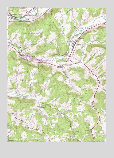
Franklin, NY USGS Topographic Map
Click on map above to begin viewing in our Map Viewer.

This topographic map contains these locations and features:
Feature Name Type Latitude Longitude GNIS ID View Map
Barnes CemeteryCemeteryN42.3552°W75.1494°943037View Map
Bartlett HollowPopulated PlaceN42.3198°W75.1818°943098View Map
Bennett HollowValleyN42.3015°W75.1338°969875View Map
Brier CreekStreamN42.3690°W75.2143°944734View Map
BrooklynPopulated PlaceN42.3442°W75.1704°944840View Map
Chapel Hill SchoolSchoolN42.2615°W75.2110°946379View Map
Community Bible ChurchChurchN42.3404°W75.1671°2615796View Map
East Branch Handsome BrookStreamN42.3226°W75.1624°970092View Map
East SidneyPopulated PlaceN42.3301°W75.2321°972431View Map
East Sidney CemeteryCemeteryN42.3421°W75.2489°949247View Map
East Sidney LakeReservoirN42.3272°W75.2125°973322View Map
FranklinPopulated PlaceN42.3406°W75.1652°950606View Map
Franklin Central SchoolSchoolN42.3386°W75.1679°2669021View Map
Franklin DepotPopulated PlaceN42.2826°W75.2093°950611View Map
Franklin Fire Department Fire HouseBuildingN42.3391°W75.1665°2718623View Map
Franklin Free LibraryBuildingN42.3387°W75.1658°2617277View Map
Franklin Post OfficePost OfficeN42.3403°W75.1650°2617927View Map
Gallop HillSummitN42.2526°W75.2052°950858View Map
Handsome BrookStreamN42.3267°W75.1913°952151View Map
Heathen HillSummitN42.2987°W75.1532°952498View Map
Hodges HillSummitN42.2870°W75.2355°952918View Map
Johnson HillSummitN42.2912°W75.1571°954121View Map
Lawton HillSummitN42.3034°W75.2121°955118View Map
LeontaPopulated PlaceN42.3598°W75.1274°955218View Map
MerrickvillePopulated PlaceN42.2754°W75.1782°956998View Map
Mount ZionSummitN42.3576°W75.1924°971886View Map
Oak HillSummitN42.3376°W75.1332°959106View Map
Ouleout Valley CemeteryCemeteryN42.3475°W75.1610°959589View Map
Palmer HillSummitN42.2629°W75.1329°959787View Map
Pat PondLakeN42.3305°W75.1703°959970View Map
Plymouth Community Church CemeteryCemeteryN42.2610°W75.1457°960785View Map
RoundtopSummitN42.3334°W75.1599°963039View Map
Saint Paul's Episcopal ChurchChurchN42.3407°W75.1654°2617005View Map
School Number 16 (historical)SchoolN42.2926°W75.2152°975116View Map
School Number 18 (historical)SchoolN42.2637°W75.1307°975143View Map
School Number 4 (historical)SchoolN42.3345°W75.2377°975316View Map
School Number 6 (historical)SchoolN42.3686°W75.2450°2106392View Map
Sherman HillSummitN42.3059°W75.1921°965079View Map
The Knoll CemeteryCemeteryN42.3219°W75.1789°2548268View Map
Treadwell CreekStreamN42.3667°W75.1296°967776View Map
Unatego Junior - Senior High SchoolSchoolN42.3707°W75.2254°2597890View Map
Village of FranklinCivilN42.3417°W75.1660°2390849View Map
Wells BridgePopulated PlaceN42.3676°W75.2454°969039View Map
Wells Bridge Volunteer Fire DepartmentBuildingN42.3687°W75.2456°2718588View Map
West Branch Handsome BrookStreamN42.3226°W75.1624°970760View Map
Wheat HillSummitN42.3137°W75.2243°970983View Map
WoodfordLocaleN42.2584°W75.1657°971630View Map

Note: Coordinates in the location and feature list above are referenced to NAD83 datum.


Copyright (C) 2008-2025 Ryan Niemi / Sunset Dynamics ... All Rights Reserved