TopoQuest Logo
Do you find TopoQuest useful?
Help keep TopoQuest running and adding new maps/features by donating!
Bitcoin:  19c7KJd3qBynnjoSw5npx9KScwjBe4ifkT
Litecoin:  LXs6TkuXGGXo1vDsWCkWVdjQX94eUKd6ui
Home View Maps Find Maps Find Places Resources & Links


Otego, New York Topographic Map

USGS Map Title: Otego, NY
USGS Map MRC: 42075D2
DRG (GeoTIFF) Download: o42075d2.tif


Neighboring USGS Topographic Map Quads:


  New Berlin South, NY  
42075E3
 

  Morris, NY  
42075E2
 

  Mount Vision, NY  
42075E1
 

  Gilbertsville, NY  
42075D3
 

  Otego, NY  
42075D2
 

  Oneonta, NY  
42075D1
 

  Unadilla, NY  
42075C3
 

  Franklin, NY  
42075C2
 

  Treadwell, NY  
42075C1


Map MRC Location:

N43°
W76°
N43°
W75°
H8 H7 H6 H5 H4 H3 H2 H1
G8 G7 G6 G5 G4 G3 G2 G1
F8 F7 F6 F5 F4 F3 F2 F1
E8 E7 E6 E5 E4 E3 E2 E1
D8 D7 D6 D5 D4 D3 D2 D1
C8 C7 C6 C5 C4 C3 C2 C1
B8 B7 B6 B5 B4 B3 B2 B1
A8 A7 A6 A5 A4 A3 A2 A1
N42°
W76°
N42°
W75°

Otego, NY USGS 1:24K Topographic Map Preview:
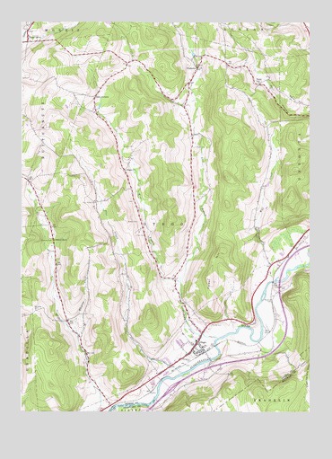
Otego, NY USGS Topographic Map
Click on map above to begin viewing in our Map Viewer.

This topographic map contains these locations and features:
Feature Name Type Latitude Longitude GNIS ID View Map
Baker HillSummitN42.4751°W75.1346°942833View Map
Bundy CemeteryCemeteryN42.4031°W75.1677°945177View Map
Burdick CemeteryCemeteryN42.4601°W75.2063°945200View Map
Calder HillSummitN42.4267°W75.1627°945449View Map
Carr CemeteryCemeteryN42.4316°W75.2000°945895View Map
Cook CornersLocaleN42.4762°W75.2185°947343View Map
East Branch Otsdawa CreekStreamN42.4165°W75.1810°949010View Map
Emmons CemeteryCemeteryN42.4299°W75.2363°949642View Map
Evergreen CemeteryCemeteryN42.3930°W75.1763°949751View Map
First Christian ChurchChurchN42.4525°W75.2051°2667414View Map
Flax Island CemeteryCemeteryN42.4425°W75.2178°950263View Map
Flax Island CreekStreamN42.3873°W75.1804°950264View Map
Harris Memorial LibraryBuildingN42.3960°W75.1743°2598962View Map
Hopkins CemeteryCemeteryN42.4360°W75.1995°953196View Map
Lundins Tree FarmLocaleN42.4031°W75.1569°2557725View Map
Maple GrovePopulated PlaceN42.4945°W75.2477°956392View Map
Merithew CemeteryCemeteryN42.4076°W75.2437°956986View Map
Mill CreekStreamN42.4187°W75.1377°957218View Map
Mill Creek EstatesPopulated PlaceN42.4250°W75.1422°2516337View Map
Northup CemeteryCemeteryN42.4109°W75.1418°958986View Map
OtegoPopulated PlaceN42.3973°W75.1735°959533View Map
Otego Baptist ChurchChurchN42.3937°W75.1768°2598300View Map
Otego ChurchChurchN42.4523°W75.2052°959534View Map
Otego Elementary SchoolSchoolN42.3977°W75.1740°2597886View Map
Otego Emergency SquadBuildingN42.3971°W75.1725°2720122View Map
Otego Post OfficePost OfficeN42.3969°W75.1725°2599217View Map
Otego Presbyterian ChurchChurchN42.3959°W75.1724°2597905View Map
Otego United Methodist ChurchChurchN42.3941°W75.1753°2597906View Map
Otego Volunteer Fire DepartmentBuildingN42.3970°W75.1726°2718394View Map
OtsdawaPopulated PlaceN42.4848°W75.1743°959549View Map
Otsdawa CemeteryCemeteryN42.4815°W75.1768°2558769View Map
Otsdawa CreekStreamN42.3984°W75.1649°959550View Map
Perry SchoolSchoolN42.4806°W75.1471°960211View Map
Pope CemeteryCemeteryN42.4600°W75.1744°960925View Map
Presbyterian CemeteryCemeteryN42.3962°W75.1718°2558770View Map
Quackenbush CemeteryCemeteryN42.4146°W75.1353°962022View Map
School Number 4 (historical)SchoolN42.4298°W75.2357°975320View Map
Seefield FarmLocaleN42.4844°W75.2483°2557728View Map
Town of OtegoCivilN42.4303°W75.1867°979327View Map
Village of OtegoCivilN42.3928°W75.1801°2391042View Map
West Branch Otsdawa CreekStreamN42.4165°W75.1810°969131View Map
Wheaton CreekStreamN42.3995°W75.2254°970990View Map

Note: Coordinates in the location and feature list above are referenced to NAD83 datum.


Copyright (C) 2008-2025 Ryan Niemi / Sunset Dynamics ... All Rights Reserved