TopoQuest Logo
Do you find TopoQuest useful?
Help keep TopoQuest running and adding new maps/features by donating!
Bitcoin:  19c7KJd3qBynnjoSw5npx9KScwjBe4ifkT
Litecoin:  LXs6TkuXGGXo1vDsWCkWVdjQX94eUKd6ui
Home View Maps Find Maps Find Places Resources & Links


Frankton, Indiana Topographic Map

USGS Map Title: Frankton, IN
USGS Map MRC: 40085B7
DRG (GeoTIFF) Download: o40085b7.tif


Neighboring USGS Topographic Map Quads:


  Windfall, IN  
40085C8
 

  Elwood, IN  
40085C7
 

  Alexandria, IN  
40085C6
 

  Omega, IN  
40085B8
 

  Frankton, IN  
40085B7
 

  Anderson North, IN  
40085B6
 

  Riverwood, IN  
40085A8
 

  Lapel, IN  
40085A7
 

  Anderson South, IN  
40085A6


Map MRC Location:

N41°
W86°
N41°
W85°
H8 H7 H6 H5 H4 H3 H2 H1
G8 G7 G6 G5 G4 G3 G2 G1
F8 F7 F6 F5 F4 F3 F2 F1
E8 E7 E6 E5 E4 E3 E2 E1
D8 D7 D6 D5 D4 D3 D2 D1
C8 C7 C6 C5 C4 C3 C2 C1
B8 B7 B6 B5 B4 B3 B2 B1
A8 A7 A6 A5 A4 A3 A2 A1
N40°
W86°
N40°
W85°

Frankton, IN USGS 1:24K Topographic Map Preview:
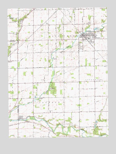
Frankton, IN USGS Topographic Map
Click on map above to begin viewing in our Map Viewer.

This topographic map contains these locations and features:
Feature Name Type Latitude Longitude GNIS ID View Map
AromaPopulated PlaceN40.1995°W85.8741°430277View Map
Big Duck CreekStreamN40.2498°W85.8458°431035View Map
Camp KikthawenundParkN40.1714°W85.8197°432041View Map
Elm RunStreamN40.1414°W85.7625°434125View Map
FranktonPopulated PlaceN40.2228°W85.7789°434789View Map
Frankton Ambulance ServiceBuildingN40.2217°W85.7784°2719336View Map
Frankton Elementary and Junior SchoolSchoolN40.2231°W85.7764°447389View Map
Frankton High SchoolSchoolN40.2206°W85.7733°447385View Map
Frankton Police DepartmentBuildingN40.2232°W85.7797°2758374View Map
Frankton Volunteer Fire Department Station 1BuildingN40.2215°W85.7802°2625766View Map
Howard CemeteryCemeteryN40.2345°W85.7726°436534View Map
Ironwood ChurchChurchN40.1717°W85.7661°436833View Map
Knights of Pythias CemeteryCemeteryN40.2190°W85.7796°436683View Map
Lamberson DitchCanalN40.2023°W85.8553°437577View Map
Little Duck CreekStreamN40.2498°W85.8458°438049View Map
McClure DitchCanalN40.2492°W85.8011°438801View Map
Mount Pleasant CemeteryCemeteryN40.2260°W85.8636°439664View Map
Neese CemeteryCemeteryN40.1628°W85.8346°439978View Map
PerkinsvillePopulated PlaceN40.1442°W85.8614°441022View Map
Perkinsville CemeteryCemeteryN40.1409°W85.8519°441023View Map
Polywog CreekStreamN40.2367°W85.8600°441417View Map
Prewett CemeteryCemeteryN40.2073°W85.8070°441586View Map
Shell CemeteryCemeteryN40.1938°W85.8226°443352View Map
Sigler CemeteryCemeteryN40.2264°W85.7854°443484View Map
Stottlemyer AirportAirportN40.2255°W85.8154°2676901View Map
Town of FranktonCivilN40.2210°W85.7719°2396949View Map
Township of JacksonCivilN40.1444°W85.8165°453454View Map
Township of Pipe CreekCivilN40.2479°W85.8011°453741View Map
Walls Hog FarmLocaleN40.2461°W85.7656°2710711View Map

Note: Coordinates in the location and feature list above are referenced to NAD83 datum.


Copyright (C) 2008-2025 Ryan Niemi / Sunset Dynamics ... All Rights Reserved