TopoQuest Logo
Do you find TopoQuest useful?
Help keep TopoQuest running and adding new maps/features by donating!
Bitcoin:  19c7KJd3qBynnjoSw5npx9KScwjBe4ifkT
Litecoin:  LXs6TkuXGGXo1vDsWCkWVdjQX94eUKd6ui
Home View Maps Find Maps Find Places Resources & Links


Frederic, Wisconsin Topographic Map

USGS Map Title: Frederic, WI
USGS Map MRC: 45092F4
DRG (GeoTIFF) Download: o45092f4.tif


Neighboring USGS Topographic Map Quads:


  Falun, WI  
45092G5
 

  Siren West, WI  
45092G4
 

  Siren East, WI  
45092G3
 

  Trade Lake, WI  
45092F5
 

  Frederic, WI  
45092F4
 

  Clam Falls, WI  
45092F3
 

  Milltown, WI  
45092E5
 

  Luck, WI  
45092E4
 

  Big Round Lake, WI  
45092E3


Map MRC Location:

N46°
W93°
N46°
W92°
H8 H7 H6 H5 H4 H3 H2 H1
G8 G7 G6 G5 G4 G3 G2 G1
F8 F7 F6 F5 F4 F3 F2 F1
E8 E7 E6 E5 E4 E3 E2 E1
D8 D7 D6 D5 D4 D3 D2 D1
C8 C7 C6 C5 C4 C3 C2 C1
B8 B7 B6 B5 B4 B3 B2 B1
A8 A7 A6 A5 A4 A3 A2 A1
N45°
W93°
N45°
W92°

Frederic, WI USGS 1:24K Topographic Map Preview:
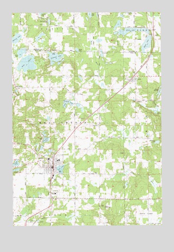
Frederic, WI USGS Topographic Map
Click on map above to begin viewing in our Map Viewer.

This topographic map contains these locations and features:
Feature Name Type Latitude Longitude GNIS ID View Map
Aspen LakeLakeN45.6956°W92.4564°1577334View Map
Black LakeLakeN45.7280°W92.4455°1561869View Map
Blom LakeLakeN45.7201°W92.4875°1561925View Map
Bohn DamDamN45.6800°W92.4752°1792605View Map
Coon LakeLakeN45.6583°W92.4600°1563370View Map
Diamond LakeLakeN45.7237°W92.4643°1563966View Map
Elbow LakeLakeN45.7390°W92.3998°1564492View Map
Fern LakeLakeN45.7259°W92.4250°1577331View Map
Fountain LakeLakeN45.6764°W92.4726°1577335View Map
FredericPopulated PlaceN45.6591°W92.4671°1565283View Map
Frederic 6 - 12 SchoolSchoolN45.6708°W92.4545°2713407View Map
Frederic Elementary SchoolSchoolN45.6345°W92.4486°2713309View Map
Frederic Elementary SchoolSchoolN45.6634°W92.4618°2713228View Map
Frederic Lookout TowerTowerN45.6363°W92.4235°1831812View Map
Frederic Police DepartmentBuildingN45.6612°W92.4671°2759921View Map
Frederic Volunteer Fire DepartmentBuildingN45.6607°W92.4678°2696957View Map
Grass LakeLakeN45.7267°W92.4924°1565768View Map
Hatchet LakeLakeN45.6572°W92.4981°1577337View Map
Hawthorn LakeLakeN45.6736°W92.3789°1577336View Map
Hickory LakeLakeN45.6974°W92.4532°1577333View Map
Hunters LakeLakeN45.7351°W92.4963°1566815View Map
LewisPopulated PlaceN45.7108°W92.4024°1567997View Map
Lewis Census Designated PlaceCensusN45.7159°W92.3964°2586525View Map
Little Dunham LakeLakeN45.7447°W92.4689°1568245View Map
Northland Municipal Ambulance FredericBuildingN45.6581°W92.4670°2698371View Map
Town of West SwedenCivilN45.6859°W92.4679°1584417View Map
Village of FredericCivilN45.6548°W92.4647°1583238View Map
West SwedenPopulated PlaceN45.7058°W92.4969°1576565View Map
Young LakeLakeN45.6616°W92.4976°1577117View Map
Young Private Airport (historical)AirportN45.6628°W92.4500°1581025View Map

Note: Coordinates in the location and feature list above are referenced to NAD83 datum.


Copyright (C) 2008-2025 Ryan Niemi / Sunset Dynamics ... All Rights Reserved