TopoQuest Logo
Do you find TopoQuest useful?
Help keep TopoQuest running and adding new maps/features by donating!
Bitcoin:  19c7KJd3qBynnjoSw5npx9KScwjBe4ifkT
Litecoin:  LXs6TkuXGGXo1vDsWCkWVdjQX94eUKd6ui
Home View Maps Find Maps Find Places Resources & Links


Fredericksburg, Missouri Topographic Map

USGS Map Title: Fredericksburg, MO
USGS Map MRC: 38091E6
DRG (GeoTIFF) Download: o38091e6.tif


Neighboring USGS Topographic Map Quads:


  Mokane East, MO  
38091F7
 

  Morrison, MO  
38091F6
 

  Gasconade, MO  
38091F5
 

  Luystown, MO  
38091E7
 

  Fredericksburg, MO  
38091E6
 

  Pershing, MO  
38091E5
 

  Linn, MO  
38091D7
 

  Cooper Hill, MO  
38091D6
 

  Goerlisch Ridge, MO  
38091D5


Map MRC Location:

N39°
W92°
N39°
W91°
H8 H7 H6 H5 H4 H3 H2 H1
G8 G7 G6 G5 G4 G3 G2 G1
F8 F7 F6 F5 F4 F3 F2 F1
E8 E7 E6 E5 E4 E3 E2 E1
D8 D7 D6 D5 D4 D3 D2 D1
C8 C7 C6 C5 C4 C3 C2 C1
B8 B7 B6 B5 B4 B3 B2 B1
A8 A7 A6 A5 A4 A3 A2 A1
N38°
W92°
N38°
W91°

Fredericksburg, MO USGS 1:24K Topographic Map Preview:
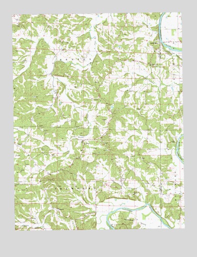
Fredericksburg, MO USGS Topographic Map
Click on map above to begin viewing in our Map Viewer.

This topographic map contains these locations and features:
Feature Name Type Latitude Longitude GNIS ID View Map
AudPopulated PlaceN38.5803°W91.7207°740644View Map
Baecker CemeteryCemeteryN38.5505°W91.6308°713528View Map
Bailey Creek Catholic Church (historical)ChurchN38.5520°W91.7021°743818View Map
Baileys Creek CemeteryCemeteryN38.5498°W91.6989°713550View Map
Evangical Church (historical)ChurchN38.5023°W91.7091°743817View Map
FredericksburgPopulated PlaceN38.6075°W91.6416°729492View Map
Fredericksburg ChurchChurchN38.5948°W91.6485°718188View Map
Harris CemeteryCemeteryN38.5431°W91.7202°719144View Map
Heckman BendBendN38.5048°W91.6593°719334View Map
HopePopulated PlaceN38.5284°W91.6713°740938View Map
Hope CreekStreamN38.5142°W91.6532°719790View Map
Karschnick CemeteryCemeteryN38.5207°W91.6629°720477View Map
Koelling IslandsIslandN38.5420°W91.6279°720682View Map
Lake IsabellReservoirN38.5736°W91.7152°765230View Map
Lake Isabell DamDamN38.5750°W91.7152°765229View Map
Lay High School (historical)SchoolN38.6170°W91.7202°743816View Map
Liberty School (historical)SchoolN38.5337°W91.7254°743815View Map
Mint HillPopulated PlaceN38.5492°W91.7471°741075View Map
Mint Hill Post Office (historical)Post OfficeN38.5481°W91.7454°759488View Map
Mud Creek School (historical)SchoolN38.5195°W91.6277°744365View Map
Oklahoma ChurchChurchN38.5120°W91.7179°729362View Map
Oshawa (historical)BuildingN38.5064°W91.6616°743819View Map
Plattners CemeteryCemeteryN38.5798°W91.6657°724471View Map
Plattners School (historical)SchoolN38.5809°W91.6635°743814View Map
Richland CreekStreamN38.5975°W91.6252°725273View Map
Salem ChurchChurchN38.5406°W91.6560°725935View Map
Salem Presbyterian ChurchChurchN38.5384°W91.6507°743813View Map
Southwest CemeteryCemeteryN38.5692°W91.6565°726815View Map
Southwest Church (historical)ChurchN38.5687°W91.6560°743820View Map
Stock CemeteryCemeteryN38.5827°W91.7033°727119View Map
WelcomeLocaleN38.5081°W91.7352°728489View Map
Wilhoit CemeteryCemeteryN38.5982°W91.7426°728859View Map
Wittenbach School (historical)SchoolN38.6187°W91.6638°743812View Map
Woods CemeteryCemeteryN38.6220°W91.7452°729117View Map

Note: Coordinates in the location and feature list above are referenced to NAD83 datum.


Copyright (C) 2008-2024 Ryan Niemi / Sunset Dynamics ... All Rights Reserved