TopoQuest Logo
Do you find TopoQuest useful?
Help keep TopoQuest running and adding new maps/features by donating!
Bitcoin:  19c7KJd3qBynnjoSw5npx9KScwjBe4ifkT
Litecoin:  LXs6TkuXGGXo1vDsWCkWVdjQX94eUKd6ui
Home View Maps Find Maps Find Places Resources & Links


Cooper Hill, Missouri Topographic Map

USGS Map Title: Cooper Hill, MO
USGS Map MRC: 38091D6
DRG (GeoTIFF) Download: o38091d6.tif


Neighboring USGS Topographic Map Quads:


  Luystown, MO  
38091E7
 

  Fredericksburg, MO  
38091E6
 

  Pershing, MO  
38091E5
 

  Linn, MO  
38091D7
 

  Cooper Hill, MO  
38091D6
 

  Goerlisch Ridge, MO  
38091D5
 

  Summerfield, MO  
38091C7
 

  Belle, MO  
38091C6
 

  Owensville West, MO  
38091C5


Map MRC Location:

N39°
W92°
N39°
W91°
H8 H7 H6 H5 H4 H3 H2 H1
G8 G7 G6 G5 G4 G3 G2 G1
F8 F7 F6 F5 F4 F3 F2 F1
E8 E7 E6 E5 E4 E3 E2 E1
D8 D7 D6 D5 D4 D3 D2 D1
C8 C7 C6 C5 C4 C3 C2 C1
B8 B7 B6 B5 B4 B3 B2 B1
A8 A7 A6 A5 A4 A3 A2 A1
N38°
W92°
N38°
W91°

Cooper Hill, MO USGS 1:24K Topographic Map Preview:
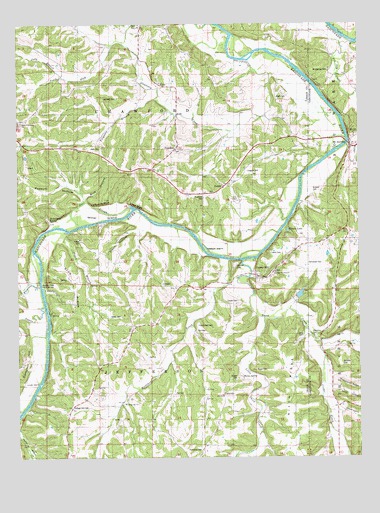
Cooper Hill, MO USGS Topographic Map
Click on map above to begin viewing in our Map Viewer.

This topographic map contains these locations and features:
Feature Name Type Latitude Longitude GNIS ID View Map
Bacon SpringSpringN38.3984°W91.6681°738010View Map
Baker CemeteryCemeteryN38.4160°W91.7125°713568View Map
Bend School (historical)SchoolN38.4953°W91.6577°743827View Map
Blue HollowValleyN38.4503°W91.7243°714409View Map
Bueker CemeteryCemeteryN38.3978°W91.6698°714997View Map
Bumper CemeteryCemeteryN38.4514°W91.6399°715034View Map
Butte CemeteryCemeteryN38.4791°W91.6548°741890View Map
Cedar BluffCliffN38.4473°W91.7054°715566View Map
Cisco HollowValleyN38.4406°W91.7060°715853View Map
Clod RidgeRidgeN38.4273°W91.7296°716006View Map
College Hill CemeteryCemeteryN38.3905°W91.7302°716117View Map
College Hill ChurchChurchN38.3906°W91.7113°741900View Map
College Hill DamDamN38.3934°W91.6935°765227View Map
College Hill LakeReservoirN38.3934°W91.6935°765228View Map
Contrary CreekStreamN38.4892°W91.6638°716209View Map
Cooper CemeteryCemeteryN38.4204°W91.6699°741896View Map
Cooper HillPopulated PlaceN38.4273°W91.6616°716281View Map
Cox - Cooper CemeteryCemeteryN38.4132°W91.6844°741897View Map
Cox CemeteryCemeteryN38.4495°W91.6699°741892View Map
Crider CreekStreamN38.4145°W91.6443°716497View Map
Crider HollowValleyN38.4917°W91.6296°716498View Map
Deer SloughGutN38.4478°W91.7257°716816View Map
Drewel Ford (historical)Populated PlaceN38.3992°W91.6385°740814View Map
Edwards BluffCliffN38.4478°W91.7227°717411View Map
Evangel Saint Paul ChurchChurchN38.4287°W91.6560°741895View Map
Ferguson BranchStreamN38.4784°W91.6991°738009View Map
Feuersville (historical)Populated PlaceN38.3937°W91.6749°740860View Map
Feuersville Church (historical)ChurchN38.3781°W91.6824°718276View Map
Feuersville Post Office (historical)Post OfficeN38.3935°W91.6751°2747181View Map
FreedomPopulated PlaceN38.4637°W91.6907°718194View Map
Fuersville CemeteryCemeteryN38.3770°W91.6835°741899View Map
Garfield School (historical)SchoolN38.3900°W91.7113°729313View Map
Gerloff HollowValleyN38.3953°W91.6346°718409View Map
Glenco LakeReservoirN38.4406°W91.6510°718501View Map
Haynes CemeteryCemeteryN38.4575°W91.6655°741891View Map
Heckman SchoolSchoolN38.4973°W91.6582°719336View Map
Hickorynut RidgeRidgeN38.4000°W91.6254°719495View Map
Hollenback SpringSpringN38.4440°W91.7385°719712View Map
Hood HillSummitN38.4306°W91.6699°719774View Map
Judy BranchStreamN38.4853°W91.7341°738011View Map
Kidd CemeteryCemeteryN38.4639°W91.7232°741889View Map
Lake Ford (historical)Populated PlaceN38.4089°W91.7393°741000View Map
Lambeth CemeteryCemeteryN38.4789°W91.7141°741887View Map
Lane (historical)BuildingN38.4709°W91.7491°743829View Map
Lane Community ChurchChurchN38.4717°W91.7491°741888View Map
Lang CemeteryCemeteryN38.4100°W91.6463°741898View Map
Leach CemeteryCemeteryN38.4343°W91.6577°720857View Map
Little Third CreekStreamN38.4153°W91.6602°721340View Map
Lovett IslandIslandN38.3962°W91.7424°721623View Map
Massie IslandIslandN38.4362°W91.6807°721964View Map
Miller Grove SchoolSchoolN38.4564°W91.7074°722377View Map
Miller IslandIslandN38.4442°W91.7243°722380View Map
Mistaken CreekStreamN38.4320°W91.6718°722480View Map
Morton HollowValleyN38.3828°W91.7496°722668View Map
Mount SterlingPopulated PlaceN38.4650°W91.6271°729569View Map
Mount Sterling CemeteryCemeteryN38.4868°W91.6360°722897View Map
Nixon CemeteryCemeteryN38.4028°W91.6597°723382View Map
Nixon RidgeRidgeN38.4003°W91.6496°723383View Map
Owens CreekStreamN38.4195°W91.7402°723908View Map
Owensville Volunteer Fire Department Station 2BuildingN38.4641°W91.6270°2621590View Map
Patterson DamDamN38.4217°W91.6485°761979View Map
Peggy BranchStreamN38.4395°W91.7327°724183View Map
Phelps CemeteryCemeteryN38.4384°W91.7268°724279View Map
Pin Oak ChurchChurchN38.4681°W91.6266°744380View Map
Pin Oak CreekStreamN38.4950°W91.6271°754133View Map
Pointers CreekStreamN38.4239°W91.7418°724695View Map
Pointers Creek Public AccessLocaleN38.4248°W91.7424°741893View Map
Possum HollowValleyN38.4503°W91.7263°724780View Map
Possumtown SchoolSchoolN38.4614°W91.6663°729373View Map
Postoak SchoolSchoolN38.4039°W91.6768°729374View Map
RyorsPopulated PlaceN38.4825°W91.6982°729382View Map
Ryors ChurchChurchN38.4998°W91.7054°741886View Map
Ryors School (historical)SchoolN38.4848°W91.6988°743826View Map
Schneider CemeteryCemeteryN38.4310°W91.6442°741894View Map
Sherrill HollowValleyN38.3884°W91.6321°726339View Map
Smith HillSummitN38.4017°W91.6313°726617View Map
South Fork Contrary CreekStreamN38.4937°W91.7157°738012View Map
Success School (historical)SchoolN38.4206°W91.7149°727211View Map
Third CreekStreamN38.4317°W91.6671°727572View Map
Triumph (historical)BuildingN38.4025°W91.7135°743828View Map
UsefulLocaleN38.4531°W91.6738°728087View Map
Valentine FordPopulated PlaceN38.4114°W91.6382°741333View Map
Wildcat SchoolSchoolN38.4973°W91.7282°728844View Map

Note: Coordinates in the location and feature list above are referenced to NAD83 datum.


Copyright (C) 2008-2024 Ryan Niemi / Sunset Dynamics ... All Rights Reserved