TopoQuest Logo
Do you find TopoQuest useful?
Help keep TopoQuest running and adding new maps/features by donating!
Bitcoin:  19c7KJd3qBynnjoSw5npx9KScwjBe4ifkT
Litecoin:  LXs6TkuXGGXo1vDsWCkWVdjQX94eUKd6ui
Home View Maps Find Maps Find Places Resources & Links


Goerlisch Ridge, Missouri Topographic Map

USGS Map Title: Goerlisch Ridge, MO
USGS Map MRC: 38091D5
DRG (GeoTIFF) Download: o38091d5.tif


Neighboring USGS Topographic Map Quads:


  Fredericksburg, MO  
38091E6
 

  Pershing, MO  
38091E5
 

  Swiss, MO  
38091E4
 

  Cooper Hill, MO  
38091D6
 

  Goerlisch Ridge, MO  
38091D5
 

  Rosebud, MO  
38091D4
 

  Belle, MO  
38091C6
 

  Owensville West, MO  
38091C5
 

  Owensville East, MO  
38091C4


Map MRC Location:

N39°
W92°
N39°
W91°
H8 H7 H6 H5 H4 H3 H2 H1
G8 G7 G6 G5 G4 G3 G2 G1
F8 F7 F6 F5 F4 F3 F2 F1
E8 E7 E6 E5 E4 E3 E2 E1
D8 D7 D6 D5 D4 D3 D2 D1
C8 C7 C6 C5 C4 C3 C2 C1
B8 B7 B6 B5 B4 B3 B2 B1
A8 A7 A6 A5 A4 A3 A2 A1
N38°
W92°
N38°
W91°

Goerlisch Ridge, MO USGS 1:24K Topographic Map Preview:
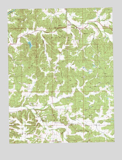
Goerlisch Ridge, MO USGS Topographic Map
Click on map above to begin viewing in our Map Viewer.

This topographic map contains these locations and features:
Feature Name Type Latitude Longitude GNIS ID View Map
Advent CemeteryCemeteryN38.3765°W91.5670°741870View Map
Atkins CemeteryCemeteryN38.4821°W91.5451°741865View Map
Bay School (historical)SchoolN38.4964°W91.5596°744382View Map
Bethel Baptist Church (historical)ChurchN38.4134°W91.6004°744383View Map
Brinkman CreekStreamN38.4856°W91.5293°714711View Map
Brushy BranchStreamN38.4114°W91.5746°714882View Map
Campmeeting HollowValleyN38.4987°W91.6160°715324View Map
Cave HillSummitN38.4845°W91.5666°715514View Map
Cave HillPopulated PlaceN38.4848°W91.5518°737996View Map
Cedar BranchStreamN38.4067°W91.5991°715573View Map
Cedar HillSummitN38.3831°W91.5629°715602View Map
Crow HollowValleyN38.4795°W91.5843°737998View Map
Drusch CemeteryCemeteryN38.4255°W91.5998°741866View Map
Fry RidgeRidgeN38.4492°W91.5966°718274View Map
Gasconade CountyCivilN38.4409°W91.5079°758491View Map
Goerlisch RidgeRidgeN38.4570°W91.5641°718537View Map
Goerlisch SchoolSchoolN38.4534°W91.5641°718538View Map
Holte CreekStreamN38.4853°W91.5488°719739View Map
Hunke CreekStreamN38.4098°W91.6104°738000View Map
Jenkins CemeteryCemeteryN38.4116°W91.5815°741868View Map
Jenkins School (historical)SchoolN38.3975°W91.5638°729523View Map
Kings LookoutLocaleN38.4978°W91.6046°720625View Map
Lake Timber RidgeReservoirN38.4669°W91.5988°758378View Map
Lake Timber Ridge DamDamN38.4684°W91.6018°764599View Map
Laubert CemeteryCemeteryN38.4339°W91.6002°720830View Map
Loesche RidgeRidgeN38.3862°W91.5371°721404View Map
M E Church (historical)ChurchN38.4689°W91.6182°744381View Map
MandaLocaleN38.3942°W91.5121°740389View Map
Manda Post Office (historical)Post OfficeN38.3942°W91.5121°759525View Map
Manda SchoolSchoolN38.3981°W91.5060°721786View Map
Mickey BranchStreamN38.4131°W91.5671°738001View Map
Mount Sterling SchoolSchoolN38.4500°W91.6152°722898View Map
Neese SchoolSchoolN38.4023°W91.6213°723152View Map
Neese SchoolSchoolN38.4834°W91.5104°723153View Map
New WoollamPopulated PlaceN38.3770°W91.5729°729580View Map
New Woollam Church (historical)ChurchN38.3764°W91.5638°744384View Map
Nubbin RidgeRidgeN38.3859°W91.6077°723535View Map
Number 538 DamDamN38.4467°W91.5418°764533View Map
Old WoollamPopulated PlaceN38.3928°W91.5535°741118View Map
Pilot KnobsSummitN38.4781°W91.5343°724354View Map
Pin Oak BluffCliffN38.4970°W91.6204°754132View Map
Saint Johns ChurchChurchN38.4014°W91.5735°741869View Map
Saint Paul School (historical)SchoolN38.4017°W91.5741°725874View Map
Schulte CreekStreamN38.4862°W91.5227°737995View Map
South Branch Pin Oak CreekStreamN38.4795°W91.5843°737999View Map
Suelthaus FordPopulated PlaceN38.4075°W91.5960°741303View Map
Third Creek CemeteryCemeteryN38.4123°W91.5999°741867View Map
Township of Third CreekCivilN38.3924°W91.5811°766663View Map
Weigand CreekStreamN38.4689°W91.6193°713118View Map
Wiggins SchoolSchoolN38.4681°W91.6166°729693View Map
Witte Ford (historical)Populated PlaceN38.4109°W91.5768°741370View Map
Zoar ChurchChurchN38.4070°W91.5296°748484View Map

Note: Coordinates in the location and feature list above are referenced to NAD83 datum.


Copyright (C) 2008-2024 Ryan Niemi / Sunset Dynamics ... All Rights Reserved