TopoQuest Logo
Do you find TopoQuest useful?
Help keep TopoQuest running and adding new maps/features by donating!
Bitcoin:  19c7KJd3qBynnjoSw5npx9KScwjBe4ifkT
Litecoin:  LXs6TkuXGGXo1vDsWCkWVdjQX94eUKd6ui
Home View Maps Find Maps Find Places Resources & Links


Pershing, Missouri Topographic Map

USGS Map Title: Pershing, MO
USGS Map MRC: 38091E5
DRG (GeoTIFF) Download: o38091e5.tif


Neighboring USGS Topographic Map Quads:


  Morrison, MO  
38091F6
 

  Gasconade, MO  
38091F5
 

  Hermann, MO  
38091F4
 

  Fredericksburg, MO  
38091E6
 

  Pershing, MO  
38091E5
 

  Swiss, MO  
38091E4
 

  Cooper Hill, MO  
38091D6
 

  Goerlisch Ridge, MO  
38091D5
 

  Rosebud, MO  
38091D4


Map MRC Location:

N39°
W92°
N39°
W91°
H8 H7 H6 H5 H4 H3 H2 H1
G8 G7 G6 G5 G4 G3 G2 G1
F8 F7 F6 F5 F4 F3 F2 F1
E8 E7 E6 E5 E4 E3 E2 E1
D8 D7 D6 D5 D4 D3 D2 D1
C8 C7 C6 C5 C4 C3 C2 C1
B8 B7 B6 B5 B4 B3 B2 B1
A8 A7 A6 A5 A4 A3 A2 A1
N38°
W92°
N38°
W91°

Pershing, MO USGS 1:24K Topographic Map Preview:
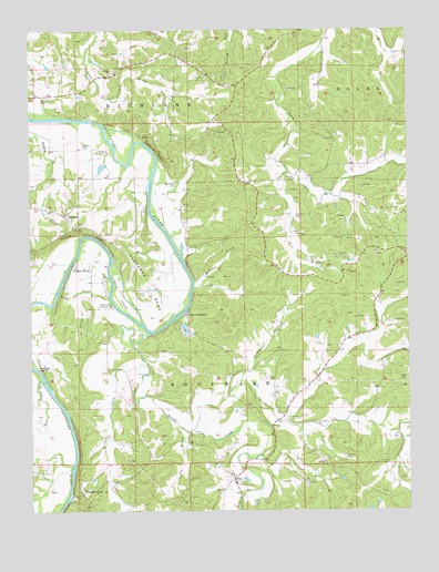
Pershing, MO USGS Topographic Map
Click on map above to begin viewing in our Map Viewer.

This topographic map contains these locations and features:
Feature Name Type Latitude Longitude GNIS ID View Map
Ahring CreekStreamN38.5553°W91.5991°713172View Map
Baecker CemeteryCemeteryN38.6070°W91.6213°713529View Map
BayPopulated PlaceN38.5084°W91.5585°713749View Map
Bethel ChurchChurchN38.5075°W91.5343°714056View Map
Bickmeyer CemeteryCemeteryN38.5850°W91.5779°714124View Map
Bohl CemeteryCemeteryN38.5714°W91.5371°714486View Map
Brant CemeteryCemeteryN38.5795°W91.5754°714640View Map
Brown ShantyPopulated PlaceN38.5512°W91.5746°714790View Map
Brown Shanty FerryLocaleN38.5539°W91.5724°744366View Map
Brown Shanty LakeReservoirN38.5474°W91.5741°763875View Map
Brown Shanty Lake DamDamN38.5484°W91.5735°763874View Map
Church BluffCliffN38.5725°W91.6096°715843View Map
Clausner BendBendN38.5589°W91.5868°715902View Map
Eikerman CemeteryCemeteryN38.5767°W91.5379°717426View Map
Emo BranchStreamN38.5228°W91.5785°717586View Map
Feigler FerryPopulated PlaceN38.5639°W91.6110°717877View Map
Harring Lake DamDamN38.5084°W91.6052°765280View Map
Helds IslandIslandN38.5564°W91.5966°719344View Map
Helds Island Public AccessLocaleN38.5531°W91.5979°719345View Map
Hoppe School (historical)SchoolN38.6164°W91.6143°744367View Map
Keller CemeteryCemeteryN38.5950°W91.6079°720496View Map
Krueger FordPopulated PlaceN38.5048°W91.6088°720701View Map
Lost Hill School (historical)SchoolN38.5392°W91.5954°744373View Map
Miller Farm AirportAirportN38.5222°W91.5154°2679297View Map
Mud CreekStreamN38.5342°W91.6218°723013View Map
Number 75 LakeReservoirN38.5894°W91.6013°763872View Map
PershingPopulated PlaceN38.5773°W91.6143°729606View Map
Pershing Farms DamDamN38.5900°W91.6018°763871View Map
Puncheon CreekStreamN38.5206°W91.5735°725001View Map
Saint Johns ChurchChurchN38.5095°W91.5588°744372View Map
Saint Johns ChurchChurchN38.6137°W91.5993°729642View Map
Saint Pauls CemeteryCemeteryN38.5139°W91.5215°725877View Map
Saint Pauls ChurchChurchN38.5125°W91.5279°725881View Map
Second CreekStreamN38.5456°W91.5860°726176View Map
Spohrer CemeteryCemeteryN38.5936°W91.6032°726869View Map
Stoenner School (historical)SchoolN38.5339°W91.5096°744370View Map
Stolpe School (historical)SchoolN38.6214°W91.5757°744368View Map
Township of BoulwareCivilN38.5058°W91.5662°766656View Map
Turkey CreekStreamN38.5381°W91.5870°727849View Map
Turnpike BluffCliffN38.5939°W91.5831°727912View Map
Upper First Creek School (historical)SchoolN38.5806°W91.5352°744369View Map
Weidemann CreekStreamN38.5342°W91.5560°728476View Map
Weidemann School (historical)SchoolN38.5389°W91.5502°744371View Map
Williams CreekStreamN38.5581°W91.5721°728893View Map

Note: Coordinates in the location and feature list above are referenced to NAD83 datum.


Copyright (C) 2008-2025 Ryan Niemi / Sunset Dynamics ... All Rights Reserved