TopoQuest Logo
Do you find TopoQuest useful?
Help keep TopoQuest running and adding new maps/features by donating!
Bitcoin:  19c7KJd3qBynnjoSw5npx9KScwjBe4ifkT
Litecoin:  LXs6TkuXGGXo1vDsWCkWVdjQX94eUKd6ui
Home View Maps Find Maps Find Places Resources & Links


Friant, California Topographic Map

USGS Map Title: Friant, CA
USGS Map MRC: 36119H6
DRG (GeoTIFF) Download: o36119h6.tif


Neighboring USGS Topographic Map Quads:


  Little Table Mountain, CA  
37119A7
 

  Millerton Lake West, CA  
37119A6
 

  Millerton Lake East, CA  
37119A5
 

  Lanes Bridge, CA  
36119H7
 

  Friant, CA  
36119H6
 

  Academy, CA  
36119H5
 

  Fresno North, CA  
36119G7
 

  Clovis, CA  
36119G6
 

  Round Mountain, CA  
36119G5


Map MRC Location:

N37°
W120°
N37°
W119°
H8 H7 H6 H5 H4 H3 H2 H1
G8 G7 G6 G5 G4 G3 G2 G1
F8 F7 F6 F5 F4 F3 F2 F1
E8 E7 E6 E5 E4 E3 E2 E1
D8 D7 D6 D5 D4 D3 D2 D1
C8 C7 C6 C5 C4 C3 C2 C1
B8 B7 B6 B5 B4 B3 B2 B1
A8 A7 A6 A5 A4 A3 A2 A1
N36°
W120°
N36°
W119°

Friant, CA USGS 1:24K Topographic Map Preview:
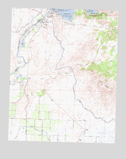
Friant, CA USGS Topographic Map
Click on map above to begin viewing in our Map Viewer.

This topographic map contains these locations and features:
Feature Name Type Latitude Longitude GNIS ID View Map
Big Dry Creek DamDamN36.8766°W119.6676°1664392View Map
Blue Oak Picnic AreaLocaleN36.9883°W119.6804°1811538View Map
Copper SubstationLocaleN36.8958°W119.6643°1654215View Map
Cottonwood CreekStreamN36.9977°W119.7074°221641View Map
El Prado (historical)Populated PlaceN36.9063°W119.7315°1665611View Map
Fresno City Fire Department Station 17BuildingN36.8888°W119.7470°2624552View Map
Fresno Copper MineMineN36.8980°W119.6690°1665619View Map
Fresno County Fire Protection District MillertonBuildingN36.9929°W119.7071°2624010View Map
FriantPopulated PlaceN36.9877°W119.7118°223946View Map
Friant Census Designated PlaceCensusN36.9847°W119.7129°2408265View Map
Friant Elementary SchoolSchoolN36.9849°W119.7096°1811551View Map
Friant Post OfficePost OfficeN36.9859°W119.7146°1811552View Map
Gates LakeLakeN36.8838°W119.6899°1665622View Map
GordonPopulated PlaceN36.8961°W119.7299°252686View Map
Grange Grove Picnic AreaLocaleN36.9872°W119.6863°1811554View Map
KFIG-FM (Fresno)TowerN36.9299°W119.6418°1665032View Map
La Playa Picnic AreaLocaleN36.9897°W119.6882°1811561View Map
Ledger IslandIslandN36.9483°W119.7404°226988View Map
Lost LakeLakeN36.9660°W119.7369°227703View Map
Lost Lake Recreation AreaParkN36.9752°W119.7332°227711View Map
Mariners PointCapeN36.9972°W119.7007°1811564View Map
Millerton Courthouse MuseumBuildingN36.9944°W119.6968°1811570View Map
Millerton Lake Fire Control StationLocaleN36.9924°W119.7068°1654329View Map
Millerton Lake State Recreation Area HeadquartersLocaleN36.9880°W119.6890°1811571View Map
Millerton School (historical)SchoolN36.9838°W119.6415°1665642View Map
Owens MountainSummitN36.9299°W119.6413°230171View Map
Pollasky School (historical)SchoolN36.9380°W119.7304°1665651View Map
Pontoon BridgeBridgeN36.9488°W119.7335°252048View Map
Shipp (historical)Populated PlaceN36.9452°W119.6751°1665666View Map
South Bay Picnic AreaLocaleN36.9988°W119.6763°1811584View Map
Table Mountain RancheriaCivilN36.9849°W119.6360°2419484View Map
Winchell Cove CampgroundLocaleN36.9955°W119.6496°238000View Map
Winchell Cove CemeteryCemeteryN36.9941°W119.6435°1811593View Map
Winchell CreekStreamN36.9972°W119.6499°269218View Map

Note: Coordinates in the location and feature list above are referenced to NAD83 datum.


Copyright (C) 2008-2025 Ryan Niemi / Sunset Dynamics ... All Rights Reserved