TopoQuest Logo
Do you find TopoQuest useful?
Help keep TopoQuest running and adding new maps/features by donating!
Bitcoin:  19c7KJd3qBynnjoSw5npx9KScwjBe4ifkT
Litecoin:  LXs6TkuXGGXo1vDsWCkWVdjQX94eUKd6ui
Home View Maps Find Maps Find Places Resources & Links


Millerton Lake East, California Topographic Map

USGS Map Title: Millerton Lake East, CA
USGS Map MRC: 37119A5
DRG (GeoTIFF) Download: o37119a5.tif


Neighboring USGS Topographic Map Quads:


  O'Neals, CA  
37119B6
 

  North Fork, CA  
37119B5
 

  Cascadel Point, CA  
37119B4
 

  Millerton Lake West, CA  
37119A6
 

  Millerton Lake East, CA  
37119A5
 

  Auberry, CA  
37119A4
 

  Friant, CA  
36119H6
 

  Academy, CA  
36119H5
 

  Humphreys Station, CA  
36119H4


Map MRC Location:

N38°
W120°
N38°
W119°
H8 H7 H6 H5 H4 H3 H2 H1
G8 G7 G6 G5 G4 G3 G2 G1
F8 F7 F6 F5 F4 F3 F2 F1
E8 E7 E6 E5 E4 E3 E2 E1
D8 D7 D6 D5 D4 D3 D2 D1
C8 C7 C6 C5 C4 C3 C2 C1
B8 B7 B6 B5 B4 B3 B2 B1
A8 A7 A6 A5 A4 A3 A2 A1
N37°
W120°
N37°
W119°

Millerton Lake East, CA USGS 1:24K Topographic Map Preview:
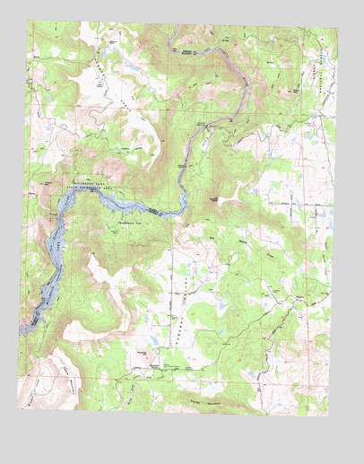
Millerton Lake East, CA USGS Topographic Map
Click on map above to begin viewing in our Map Viewer.

This topographic map contains these locations and features:
Feature Name Type Latitude Longitude GNIS ID View Map
Auberry CemeteryCemeteryN37.0142°W119.5593°256368View Map
Auberry SchoolSchoolN37.0311°W119.5649°256371View Map
Auberry ValleyValleyN37.0111°W119.5751°256372View Map
Big Sandy CreekStreamN37.0622°W119.5679°257005View Map
Big Sandy ValleyValleyN37.0416°W119.5007°257006View Map
Corlew MountainSummitN37.0016°W119.5499°258718View Map
Crook MountainSummitN37.0724°W119.6176°258930View Map
Fresno County Fire Protection District HurleyBuildingN37.0143°W119.5680°2624525View Map
Hewitt ValleyFlatN37.0838°W119.5829°261291View Map
Hideaway RanchLocaleN37.1183°W119.5929°261311View Map
Hurley Fire Control StationLocaleN37.0147°W119.5674°261660View Map
Kerchoff PowerhouseLocaleN37.0927°W119.5524°1654289View Map
Little Sandy CreekStreamN37.0419°W119.5021°262715View Map
Marshall HillSummitN37.0188°W119.5740°263227View Map
Marshall JunctionPopulated PlaceN37.0138°W119.5690°263228View Map
Marshall StationLocaleN37.0138°W119.5690°252168View Map
Millerton LakeReservoirN37.0712°W119.6025°263643View Map
PratherPopulated PlaceN37.0374°W119.5140°265024View Map
Prather Post OfficePost OfficeN37.0372°W119.5158°2789145View Map
Rock MountainSummitN37.1044°W119.5187°265509View Map
San Joaquin River Gorge Management AreaParkN37.0877°W119.5468°275607View Map
Squaw LeapCliffN37.0683°W119.5440°267635View Map
Sullivan MineMineN37.0577°W119.5868°267884View Map
Table MountainSummitN37.0188°W119.6074°268054View Map
Temperance FlatFlatN37.0602°W119.5882°268140View Map
Topham Ranch-Auberry Airport (historical)AirportN37.0997°W119.5185°1653232View Map

Note: Coordinates in the location and feature list above are referenced to NAD83 datum.


Copyright (C) 2008-2025 Ryan Niemi / Sunset Dynamics ... All Rights Reserved