TopoQuest Logo
Do you find TopoQuest useful?
Help keep TopoQuest running and adding new maps/features by donating!
Bitcoin:  19c7KJd3qBynnjoSw5npx9KScwjBe4ifkT
Litecoin:  LXs6TkuXGGXo1vDsWCkWVdjQX94eUKd6ui
Home View Maps Find Maps Find Places Resources & Links


Adamsville, Ohio Topographic Map

USGS Map Title: Adamsville, OH
USGS Map MRC: 40081A8
DRG (GeoTIFF) Download: o40081a8.tif


Neighboring USGS Topographic Map Quads:


  Trinway, OH  
40082B1
 

  Conesville, OH  
40081B8
 

  Wills Creek, OH  
40081B7
 

  Dresden, OH  
40082A1
 

  Adamsville, OH  
40081A8
 

  Otsego, OH  
40081A7
 

  Zanesville West, OH  
39082H1
 

  Zanesville East, OH  
39081H8
 

  Norwich, OH  
39081H7


Map MRC Location:

N41°
W82°
N41°
W81°
H8 H7 H6 H5 H4 H3 H2 H1
G8 G7 G6 G5 G4 G3 G2 G1
F8 F7 F6 F5 F4 F3 F2 F1
E8 E7 E6 E5 E4 E3 E2 E1
D8 D7 D6 D5 D4 D3 D2 D1
C8 C7 C6 C5 C4 C3 C2 C1
B8 B7 B6 B5 B4 B3 B2 B1
A8 A7 A6 A5 A4 A3 A2 A1
N40°
W82°
N40°
W81°

Adamsville, OH USGS 1:24K Topographic Map Preview:
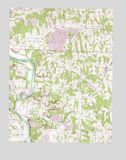
Adamsville, OH USGS Topographic Map
Click on map above to begin viewing in our Map Viewer.

This topographic map contains these locations and features:
Feature Name Type Latitude Longitude GNIS ID View Map
AdamsvillePopulated PlaceN40.0698°W81.8824°1064297View Map
Adamsville Baptist CemeteryCemeteryN40.0692°W81.8801°1964152View Map
Adamsville Elementary SchoolSchoolN40.0659°W81.8824°1054535View Map
Adamsville Fire DepartmentBuildingN40.0707°W81.8834°2549738View Map
Adamsville Post OfficePost OfficeN40.0695°W81.8818°2039688View Map
Beatty CemeteryCemeteryN40.0501°W81.9596°1037738View Map
Beech RunStreamN40.0534°W81.9735°1037786View Map
Bethesda CemeteryCemeteryN40.1217°W81.8971°1964157View Map
Bethesda Methodist ChurchChurchN40.1215°W81.8971°1070680View Map
Blount RunStreamN40.0190°W81.9779°1066590View Map
Blunt RunStreamN40.0287°W81.9924°1038157View Map
Bunting CemeteryCemeteryN40.0098°W81.9023°1038522View Map
Chestnut Ridge School (historical)SchoolN40.1042°W81.8879°1054537View Map
Church of Christ (historical)ChurchN40.0892°W81.9740°1069048View Map
Copeland IslandIslandN40.0756°W81.9821°1039360View Map
Deadmans (historical)Populated PlaceN40.0167°W81.9751°1054523View Map
DrakePopulated PlaceN40.0209°W81.9924°1048666View Map
East GreenwoodPopulated PlaceN40.0265°W81.9124°1054531View Map
East Greenwood Post Office (historical)Post OfficeN40.0265°W81.9129°2039700View Map
East Greenwood School (historical)SchoolN40.0270°W81.9215°1054532View Map
EllisPopulated PlaceN40.0462°W81.9829°1062751View Map
Ellis DamDamN40.0431°W81.9771°1040148View Map
Ellis Post Office (historical)Post OfficeN40.0459°W81.9832°2039670View Map
Ellis RunStreamN40.0448°W81.9907°1067301View Map
Ellis School (historical)SchoolN40.0495°W81.9921°1054527View Map
Fritz School (historical)SchoolN40.0656°W81.9249°1054534View Map
GilbertPopulated PlaceN40.0215°W81.9765°1064721View Map
Gilbert Post Office (historical)Post OfficeN40.0209°W81.9762°2039676View Map
Jackson IslandIslandN40.0406°W81.9857°1070788View Map
Littles School (historical)SchoolN40.1242°W81.9860°1054530View Map
Maddens (historical)Populated PlaceN40.0073°W81.9832°1067303View Map
Muskingum River Lock and Dam NumberReservoirN40.0434°W81.9782°1078841View Map
Muskingum River Lock and Dam Number 11DamN40.0435°W81.9775°1078840View Map
Muskingum River Parkway State ParkParkN40.0423°W81.9765°1054526View Map
New Victory School (historical)SchoolN40.0056°W81.8951°1054533View Map
North Branch Symmes CreekStreamN40.0828°W81.9529°1066867View Map
Otterbein School (historical)SchoolN40.0892°W81.9740°1054529View Map
Prospect Methodist ChurchChurchN40.0967°W81.9265°1070907View Map
Prospect School (historical)SchoolN40.1003°W81.9326°1054536View Map
Rock CutPopulated PlaceN40.0678°W81.9765°1062986View Map
Salem Church CemeteryCemeteryN40.0677°W81.9521°2504728View Map
Salem Methodist ChurchChurchN40.0676°W81.9526°1069072View Map
Salem School (historical)SchoolN40.0665°W81.9562°1054528View Map
Shawnee RunStreamN40.0398°W81.9904°1046160View Map
South Branch Symmes CreekStreamN40.0673°W81.9260°1066971View Map
SpencerPopulated PlaceN40.0578°W81.8868°1067308View Map
Stanley CemeteryCemeteryN40.1231°W81.9450°1046632View Map
Stoner CemeteryCemeteryN40.0836°W81.9523°1046717View Map
Symmes CreekStreamN40.0737°W81.9699°1046930View Map
Terrace ShoresPopulated PlaceN40.0166°W81.9807°2771117View Map
Township of MadisonCivilN40.0991°W81.9500°1086725View Map
Tremleys (historical)Populated PlaceN40.0292°W81.9935°1067309View Map
Vernon CemeteryCemeteryN40.0353°W81.9113°1047442View Map
Village of AdamsvilleCivilN40.0689°W81.8826°2397909View Map
Washington Baptist CemeteryCemeteryN40.0242°W81.9501°1964198View Map
Washington Township Baptist ChurchChurchN40.0248°W81.9501°1070982View Map
Whites School (historical)SchoolN40.0328°W81.9668°1054524View Map
Zanesville Honor CampLocaleN40.0309°W81.9710°1048227View Map
Zanesville State NurseryLocaleN40.0292°W81.9735°1054496View Map

Note: Coordinates in the location and feature list above are referenced to NAD83 datum.


Copyright (C) 2008-2025 Ryan Niemi / Sunset Dynamics ... All Rights Reserved