TopoQuest Logo
Do you find TopoQuest useful?
Help keep TopoQuest running and adding new maps/features by donating!
Bitcoin:  19c7KJd3qBynnjoSw5npx9KScwjBe4ifkT
Litecoin:  LXs6TkuXGGXo1vDsWCkWVdjQX94eUKd6ui
Home View Maps Find Maps Find Places Resources & Links


Wills Creek, Ohio Topographic Map

USGS Map Title: Wills Creek, OH
USGS Map MRC: 40081B7
DRG (GeoTIFF) Download: o40081b7.tif


Neighboring USGS Topographic Map Quads:


  Randle, OH  
40081C8
 

  Coshocton, OH  
40081C7
 

  Fresno, OH  
40081C6
 

  Conesville, OH  
40081B8
 

  Wills Creek, OH  
40081B7
 

  Plainfield, OH  
40081B6
 

  Adamsville, OH  
40081A8
 

  Otsego, OH  
40081A7
 

  Bloomfield, OH  
40081A6


Map MRC Location:

N41°
W82°
N41°
W81°
H8 H7 H6 H5 H4 H3 H2 H1
G8 G7 G6 G5 G4 G3 G2 G1
F8 F7 F6 F5 F4 F3 F2 F1
E8 E7 E6 E5 E4 E3 E2 E1
D8 D7 D6 D5 D4 D3 D2 D1
C8 C7 C6 C5 C4 C3 C2 C1
B8 B7 B6 B5 B4 B3 B2 B1
A8 A7 A6 A5 A4 A3 A2 A1
N40°
W82°
N40°
W81°

Wills Creek, OH USGS 1:24K Topographic Map Preview:
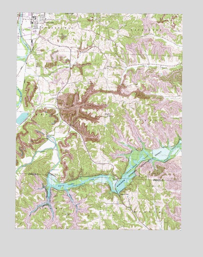
Wills Creek, OH USGS Topographic Map
Click on map above to begin viewing in our Map Viewer.

This topographic map contains these locations and features:
Feature Name Type Latitude Longitude GNIS ID View Map
Adams School (historical)SchoolN40.1376°W81.8390°1054501View Map
BaconPopulated PlaceN40.2209°W81.7754°1057280View Map
Bacon Post Office (historical)Post OfficeN40.2209°W81.7748°1967612View Map
Bacon Run School (historical)SchoolN40.2203°W81.7921°1050375View Map
Bethany CemeteryCemeteryN40.1854°W81.8590°1074760View Map
Bethany Methodist Episcopal Church (historical)ChurchN40.1851°W81.8587°1074761View Map
Big RunStreamN40.1395°W81.8501°1038026View Map
Blue RowPopulated PlaceN40.1926°W81.8618°1050371View Map
Brelsford RunStreamN40.1462°W81.8349°1066601View Map
BSA-Muskingum Valley Council LakeReservoirN40.2011°W81.8585°1079192View Map
Camp FredricksonLocaleN40.1681°W81.7996°1038697View Map
Clark School (historical)SchoolN40.2445°W81.8299°1050376View Map
Clowville (historical)Populated PlaceN40.2417°W81.8643°1067511View Map
Columbus and Southern Pond 0116-00ReservoirN40.1818°W81.7850°1079129View Map
Coshocton LandfillLocaleN40.2233°W81.8261°2677719View Map
Emler Methodist CemeteryCemeteryN40.1331°W81.8018°1964166View Map
Franklin CemeteryCemeteryN40.2001°W81.8460°1074762View Map
Franklin Methodist ChurchChurchN40.2001°W81.8446°1075135View Map
Marquand MillsPopulated PlaceN40.1459°W81.7974°1070837View Map
Marquands Mills CemeteryCemeteryN40.1557°W81.7755°1964117View Map
MaysvillePopulated PlaceN40.1542°W81.7999°1062881View Map
Maysville Methodist CemeteryCemeteryN40.1545°W81.8007°1964170View Map
Mount Zion CemeteryCemeteryN40.2344°W81.8041°1043650View Map
Old Catholic CemeteryCemeteryN40.2011°W81.7638°1964125View Map
Our Lady of Lourdes Catholic CemeteryCemeteryN40.1909°W81.8048°1964126View Map
Our Lady of Lourdes ChurchChurchN40.1906°W81.8040°1044232View Map
Pinegrove School (historical)SchoolN40.1701°W81.8215°1050373View Map
Pleasant ValleyPopulated PlaceN40.2456°W81.8540°1049094View Map
Pleasant Valley Baptist ChurchChurchN40.2484°W81.8568°1069963View Map
Pleasant Valley SchoolSchoolN40.2465°W81.8532°1063398View Map
Randle BridgeBridgeN40.2478°W81.8721°1044854View Map
Robinson RunStreamN40.2031°W81.8710°1066925View Map
Robinson School (historical)SchoolN40.2112°W81.8582°1050372View Map
Rock RunStreamN40.2273°W81.8651°1063513View Map
Royer ChapelChurchN40.1851°W81.8315°1045243View Map
Royers Chapel CemeteryCemeteryN40.1850°W81.8318°1074763View Map
Saint Johns Lutheran CemeteryCemeteryN40.2101°W81.7794°1964136View Map
Saint Pauls CemeteryCemeteryN40.2103°W81.8207°1074764View Map
Saint Pauls ChurchChurchN40.2098°W81.8199°1045762View Map
Saltworks School (historical)SchoolN40.1720°W81.7796°1050377View Map
Scheetz Tree FarmLocaleN40.2411°W81.8328°2647907View Map
Science Hill School (historical)SchoolN40.2098°W81.8257°1050374View Map
Starkey School (historical)SchoolN40.1398°W81.7924°1054503View Map
Three Rivers Fire Department Station 2BuildingN40.2442°W81.8610°2549316View Map
Township of FranklinCivilN40.1924°W81.8556°1085915View Map
Trio School (historical)SchoolN40.2117°W81.7654°1050378View Map
Will's Creek Post Office (historical)Post OfficeN40.1806°W81.8512°1967461View Map
Wills CreekPopulated PlaceN40.1801°W81.8507°1061790View Map
Wills Creek DamDamN40.1562°W81.8476°1047967View Map
Wills Creek LakeReservoirN40.1502°W81.7960°1037296View Map
Zion CemeteryCemeteryN40.1334°W81.8360°1054502View Map
Zion Evangelical Lutheran ChurchChurchN40.1340°W81.8357°1084090View Map

Note: Coordinates in the location and feature list above are referenced to NAD83 datum.


Copyright (C) 2008-2025 Ryan Niemi / Sunset Dynamics ... All Rights Reserved