TopoQuest Logo
Do you find TopoQuest useful?
Help keep TopoQuest running and adding new maps/features by donating!
Bitcoin:  19c7KJd3qBynnjoSw5npx9KScwjBe4ifkT
Litecoin:  LXs6TkuXGGXo1vDsWCkWVdjQX94eUKd6ui
Home View Maps Find Maps Find Places Resources & Links


Fulton, Missouri Topographic Map

USGS Map Title: Fulton, MO
USGS Map MRC: 38091G8
DRG (GeoTIFF) Download: o38091g8.tif


Neighboring USGS Topographic Map Quads:


  Millersburg NE, MO  
38092H1
 

  Kingdom City, MO  
38091H8
 

  Calwood, MO  
38091H7
 

  Guthrie, MO  
38092G1
 

  Fulton, MO  
38091G8
 

  Reform, MO  
38091G7
 

  New Bloomfield, MO  
38092F1
 

  Mokane West, MO  
38091F8
 

  Mokane East, MO  
38091F7


Map MRC Location:

N39°
W92°
N39°
W91°
H8 H7 H6 H5 H4 H3 H2 H1
G8 G7 G6 G5 G4 G3 G2 G1
F8 F7 F6 F5 F4 F3 F2 F1
E8 E7 E6 E5 E4 E3 E2 E1
D8 D7 D6 D5 D4 D3 D2 D1
C8 C7 C6 C5 C4 C3 C2 C1
B8 B7 B6 B5 B4 B3 B2 B1
A8 A7 A6 A5 A4 A3 A2 A1
N38°
W92°
N38°
W91°

Fulton, MO USGS 1:24K Topographic Map Preview:
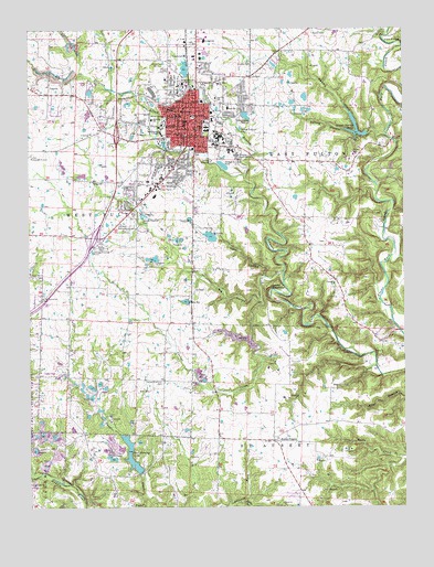
Fulton, MO USGS Topographic Map
Click on map above to begin viewing in our Map Viewer.

This topographic map contains these locations and features:
Feature Name Type Latitude Longitude GNIS ID View Map
Bartley Elementary SchoolSchoolN38.8379°W91.9534°2571047View Map
Big HollowValleyN38.8037°W91.9232°748838View Map
Brown School (historical)SchoolN38.8128°W91.9643°753367View Map
Bush Elementary SchoolSchoolN38.8542°W91.9335°749134View Map
Callaway CountyCivilN38.8355°W91.9260°758468View Map
Callaway County Sheriff's OfficeBuildingN38.8447°W91.9291°2752582View Map
Callaway Memorial GardensCemeteryN38.8253°W91.9677°754215View Map
Carver School (historical)SchoolN38.8539°W91.9535°749239View Map
Cedar Creek District Ranger StationLocaleN38.8481°W91.9768°754035View Map
Center School (historical)SchoolN38.8523°W91.9460°749319View Map
Central Callaway Fire District Station 1BuildingN38.8484°W91.9776°2620965View Map
City of FultonCivilN38.8551°W91.9512°2394834View Map
Dark HollowValleyN38.8103°W91.9218°749569View Map
Department of Conservation Central Field Fire Office FultonBuildingN38.8218°W91.9968°2620704View Map
Devils BackboneRidgeN38.8078°W91.9196°749636View Map
Dunlap CemeteryCemeteryN38.8656°W91.9255°749751View Map
Dunlap CreekStreamN38.8464°W91.8816°749752View Map
FultonPopulated PlaceN38.8467°W91.9480°750008View Map
Fulton Fire Department Station 2BuildingN38.8583°W91.9540°2621044View Map
Fulton High SchoolSchoolN38.8721°W91.9412°2571049View Map
Fulton Medical CenterHospitalN38.8434°W91.9657°2655073View Map
Fulton Middle SchoolSchoolN38.8562°W91.9424°2571048View Map
Fulton Police DepartmentBuildingN38.8353°W91.9572°2752438View Map
Fulton Post OfficePost OfficeN38.8461°W91.9487°2783052View Map
Fulton Reception and Diagnostic CenterBuildingN38.8461°W91.9226°2735654View Map
Fulton State HospitalHospitalN38.8471°W91.9378°755410View Map
Fulton TwoLocaleN38.7939°W91.9524°754037View Map
Garden Prairie School (historical)SchoolN38.8184°W91.9068°753369View Map
Glover Spring LakeReservoirN38.8487°W91.8907°761389View Map
Glover Spring Lake DamDamN38.8484°W91.8868°761388View Map
Hams PrairieAreaN38.7695°W91.9196°753757View Map
Hams PrairiePopulated PlaceN38.7673°W91.9191°750209View Map
Harbison-Walker Refractory Lake DamDamN38.8584°W91.9068°761518View Map
Hauck LakeReservoirN38.8527°W91.9804°761637View Map
Hauck Lake DamDamN38.8534°W91.9802°761636View Map
Hearnes Youth CenterBuildingN38.8417°W91.9307°755205View Map
Herring Lake DamDamN38.7584°W91.9652°761556View Map
Hillcrest CemeteryCemeteryN38.8509°W91.9355°750330View Map
Junior LakeReservoirN38.8647°W91.9480°2777765View Map
Junior Lake DamDamN38.8634°W91.9485°762235View Map
KFAL-AM (Fulton)TowerN38.8662°W91.9543°754260View Map
Kibby CemeteryCemeteryN38.8428°W91.8921°750600View Map
KKCA-FM (Fulton)TowerN38.8662°W91.9541°759095View Map
Lac PieteReservoirN38.8594°W91.9785°761520View Map
Lac Piete DamDamN38.8600°W91.9785°761519View Map
Lake BranchStreamN38.7512°W91.9299°750641View Map
Lamar School (historical)SchoolN38.8689°W91.8985°753368View Map
Maddox HollowValleyN38.8270°W91.8788°750904View Map
Mark Twain National Forest Houston - Rolla - Cedar Creek Ranger District Cedar Creek OfficeBuildingN38.8218°W91.9968°2620729View Map
Mays PrairieAreaN38.8334°W91.9918°753774View Map
McIntire SchoolSchoolN38.8515°W91.9591°751000View Map
Memorial ParkParkN38.8442°W91.9502°754179View Map
Missouri School for the DeafSchoolN38.8489°W91.9407°754033View Map
Morningside ParkParkN38.8507°W91.9281°751159View Map
Mount Carmel ChurchChurchN38.8048°W91.9957°751173View Map
Muir CemeteryCemeteryN38.7803°W91.9602°751224View Map
Muir School (historical)SchoolN38.7762°W91.9560°753365View Map
New Haven Church (historical)ChurchN38.7584°W91.9794°753366View Map
Oak Grove School (historical)SchoolN38.7781°W91.9971°753370View Map
Pace HollowValleyN38.8153°W91.8766°751470View Map
Paul Herring LakeReservoirN38.7616°W91.9662°758324View Map
PitcherPopulated PlaceN38.7503°W91.9660°751646View Map
Rice Middle School (historical)SchoolN38.8517°W91.9392°2571055View Map
Richardson Lake DamDamN38.8200°W91.9385°761508View Map
Rockhouse CreekStreamN38.8048°W91.9246°755621View Map
Saint Peters SchoolSchoolN38.8606°W91.9368°752005View Map
Smith BranchStreamN38.8367°W91.9280°755574View Map
South Callaway Fire Protection District Station 4BuildingN38.7670°W91.9199°2621605View Map
Southside CemeteryCemeteryN38.8425°W91.9455°752274View Map
Spring HollowValleyN38.8464°W91.8816°752318View Map
Stark Elementary SchoolSchoolN38.8503°W91.9417°2571052View Map
Township of East FultonCivilN38.8350°W91.9237°766377View Map
Township of West FultonCivilN38.8688°W91.9952°766387View Map
United Brethren CemeteryCemeteryN38.7828°W91.9563°752668View Map
United Brethren Church (historical)ChurchN38.7828°W91.9557°753371View Map
Westminster CollegeSchoolN38.8481°W91.9563°752831View Map
Westminster College GymnasiumBuildingN38.8483°W91.9561°2463150View Map
Wheeler High SchoolSchoolN38.8483°W91.9414°2571054View Map
Wheeler Middle SchoolSchoolN38.8483°W91.9406°2571053View Map
William Woods UniversitySchoolN38.8603°W91.9502°752909View Map
Winston Churchill Memorial and LibraryLocaleN38.8499°W91.9544°754036View Map
Youngs CreekStreamN38.8120°W91.9155°753012View Map

Note: Coordinates in the location and feature list above are referenced to NAD83 datum.


Copyright (C) 2008-2025 Ryan Niemi / Sunset Dynamics ... All Rights Reserved