TopoQuest Logo
Do you find TopoQuest useful?
Help keep TopoQuest running and adding new maps/features by donating!
Bitcoin:  19c7KJd3qBynnjoSw5npx9KScwjBe4ifkT
Litecoin:  LXs6TkuXGGXo1vDsWCkWVdjQX94eUKd6ui
Home View Maps Find Maps Find Places Resources & Links


Kingdom City, Missouri Topographic Map

USGS Map Title: Kingdom City, MO
USGS Map MRC: 38091H8
DRG (GeoTIFF) Download: o38091h8.tif


Neighboring USGS Topographic Map Quads:


  Hatton, MO  
39092A1
 

  Auxvasse, MO  
39091A8
 

  Mexico SE, MO  
39091A7
 

  Millersburg NE, MO  
38092H1
 

  Kingdom City, MO  
38091H8
 

  Calwood, MO  
38091H7
 

  Guthrie, MO  
38092G1
 

  Fulton, MO  
38091G8
 

  Reform, MO  
38091G7


Map MRC Location:

N39°
W92°
N39°
W91°
H8 H7 H6 H5 H4 H3 H2 H1
G8 G7 G6 G5 G4 G3 G2 G1
F8 F7 F6 F5 F4 F3 F2 F1
E8 E7 E6 E5 E4 E3 E2 E1
D8 D7 D6 D5 D4 D3 D2 D1
C8 C7 C6 C5 C4 C3 C2 C1
B8 B7 B6 B5 B4 B3 B2 B1
A8 A7 A6 A5 A4 A3 A2 A1
N38°
W92°
N38°
W91°

Kingdom City, MO USGS 1:24K Topographic Map Preview:
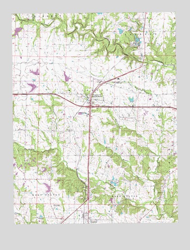
Kingdom City, MO USGS Topographic Map
Click on map above to begin viewing in our Map Viewer.

This topographic map contains these locations and features:
Feature Name Type Latitude Longitude GNIS ID View Map
Allen BranchStreamN38.9409°W91.9066°755623View Map
Atkinson Lake DamDamN38.9384°W91.9968°761848View Map
Atkinson Lake DamDamN38.9584°W91.9818°762237View Map
Atkinson School (historical)SchoolN38.9998°W91.9680°742478View Map
Backer DamDamN38.8967°W91.9352°761849View Map
Baker LakeReservoirN38.9890°W91.9173°761553View Map
Baker Lake DamDamN38.9884°W91.9168°761552View Map
Borman Lake DamDamN38.9617°W91.9818°762236View Map
Bynum CreekStreamN38.9756°W91.9132°749148View Map
CallawayPopulated PlaceN38.9153°W91.9507°740031View Map
Craig School (historical)SchoolN38.9159°W91.9521°743521View Map
Dorsey School (historical)SchoolN38.9025°W91.9716°742476View Map
Ebenezer ChurchChurchN38.8931°W91.8871°717382View Map
Guthrie LakeReservoirN38.9618°W91.9589°761639View Map
Guthrie Lake DamDamN38.9600°W91.9585°761638View Map
Hardin School (historical)SchoolN38.9081°W91.9021°742474View Map
Houfs BranchStreamN38.9009°W91.8968°719885View Map
Kingdom CityPopulated PlaceN38.9528°W91.9391°720619View Map
Kingdom City Post OfficePost OfficeN38.9488°W91.9423°2783184View Map
Leeper BranchStreamN38.9945°W91.9824°720894View Map
Lehenbaur Lake Section 25 DamDamN38.9917°W91.9935°761824View Map
Maddox BranchStreamN38.8878°W91.8941°721742View Map
Maddox School (historical)SchoolN38.9517°W91.9032°742479View Map
Martien School (historical)SchoolN38.9525°W91.9613°742477View Map
McCrediePopulated PlaceN38.9600°W91.9324°738292View Map
McCredie Experiment Station DamDamN38.9467°W91.9085°761514View Map
McCredie Watershed W-1 ReservoirReservoirN38.9482°W91.9096°761515View Map
McKinney CreekStreamN38.9150°W91.8893°722148View Map
North Callaway Fire Protection District Station 1BuildingN38.9513°W91.9608°2621707View Map
North Callaway High SchoolSchoolN38.9608°W91.9194°2571037View Map
Renner DamDamN38.8900°W91.9252°761850View Map
Richland ChurchChurchN38.8967°W91.9441°725269View Map
Richland ChurchChurchN38.9306°W91.9560°725270View Map
Richland ChurchChurchN38.9312°W91.9927°725271View Map
Richland CreekStreamN38.8878°W91.8941°751869View Map
Rocky BranchStreamN38.9959°W91.9918°751938View Map
Saint Eunice School (historical)SchoolN38.8775°W91.9438°742475View Map
Sallees BranchStreamN38.9178°W91.9641°725959View Map
Sky-Go Farms AirportAirportN38.8846°W91.9700°2679336View Map
Township of McCredieCivilN38.9558°W91.9617°766381View Map
Village of Kingdom CityCivilN38.9473°W91.9390°2398350View Map

Note: Coordinates in the location and feature list above are referenced to NAD83 datum.


Copyright (C) 2008-2025 Ryan Niemi / Sunset Dynamics ... All Rights Reserved