TopoQuest Logo
Do you find TopoQuest useful?
Help keep TopoQuest running and adding new maps/features by donating!
Bitcoin:  19c7KJd3qBynnjoSw5npx9KScwjBe4ifkT
Litecoin:  LXs6TkuXGGXo1vDsWCkWVdjQX94eUKd6ui
Home View Maps Find Maps Find Places Resources & Links


Millersburg NE, Missouri Topographic Map

USGS Map Title: Millersburg NE, MO
USGS Map MRC: 38092H1
DRG (GeoTIFF) Download: o38092h1.tif


Neighboring USGS Topographic Map Quads:


  Hallsville, MO  
39092A2
 

  Hatton, MO  
39092A1
 

  Auxvasse, MO  
39091A8
 

  Millersburg, MO  
38092H2
 

  Millersburg NE, MO  
38092H1
 

  Kingdom City, MO  
38091H8
 

  Millersburg SW, MO  
38092G2
 

  Guthrie, MO  
38092G1
 

  Fulton, MO  
38091G8


Map MRC Location:

N39°
W93°
N39°
W92°
H8 H7 H6 H5 H4 H3 H2 H1
G8 G7 G6 G5 G4 G3 G2 G1
F8 F7 F6 F5 F4 F3 F2 F1
E8 E7 E6 E5 E4 E3 E2 E1
D8 D7 D6 D5 D4 D3 D2 D1
C8 C7 C6 C5 C4 C3 C2 C1
B8 B7 B6 B5 B4 B3 B2 B1
A8 A7 A6 A5 A4 A3 A2 A1
N38°
W93°
N38°
W92°

Millersburg NE, MO USGS 1:24K Topographic Map Preview:
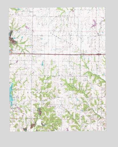
Millersburg NE, MO USGS Topographic Map
Click on map above to begin viewing in our Map Viewer.

This topographic map contains these locations and features:
Feature Name Type Latitude Longitude GNIS ID View Map
Baumgartner DamDamN38.8984°W92.1135°761516View Map
Baumgartner LakeReservoirN38.8979°W92.1124°761517View Map
Castle Lake DamDamN38.9450°W92.1168°762108View Map
Crooked Creek CampgroundLocaleN38.9237°W92.0118°754366View Map
Davis Lake DamDamN38.9700°W92.1085°762109View Map
Discwasher Incorporated DamDamN38.9584°W92.1218°762110View Map
Doctor Vaughn LakeReservoirN38.9800°W92.1014°760228View Map
EarlPopulated PlaceN38.9312°W92.0613°740822View Map
EastvillePopulated PlaceN38.9525°W92.0321°749788View Map
Grand PrairieAreaN38.9673°W92.0557°750099View Map
Hatton-McCredie Elementary SchoolSchoolN38.9718°W92.0092°729288View Map
Headache Lake DamDamN38.8750°W92.0485°761511View Map
HerefordPopulated PlaceN38.9917°W92.0938°750299View Map
Lehenbauer Lake Section 35 DamDamN38.9833°W92.0122°761554View Map
Little Dixie DamDamN38.9050°W92.1218°761522View Map
Little Dixie LakeReservoirN38.9136°W92.1235°750765View Map
Little Dixie State Wildlife Management AreaParkN38.9173°W92.1185°750766View Map
Lochwinnoch DamDamN38.9417°W92.0818°761509View Map
Lochwinnoch ReservoirReservoirN38.9428°W92.0822°761510View Map
McClellan School (historical)SchoolN38.9320°W92.0807°753761View Map
Miller School (historical)SchoolN38.9272°W92.0093°753763View Map
MillersburgPopulated PlaceN38.8987°W92.1235°751100View Map
Mount Olivet CemeteryCemeteryN38.9303°W92.0671°751183View Map
New Richland ChurchChurchN38.9264°W92.0238°751305View Map
New Richland School (historical)SchoolN38.9252°W92.0233°753765View Map
Prairie ChapelChurchN38.9273°W92.0421°751741View Map
Red Brush School (historical)SchoolN38.9094°W92.0696°753769View Map
Rising Sun ChurchChurchN38.9962°W92.0941°751889View Map
Smith DamDamN38.9700°W92.1218°764349View Map
Smith LakeReservoirN38.9696°W92.1216°764350View Map
Sunrise School (historical)SchoolN38.8941°W92.0295°753772View Map
Township of BourbonCivilN38.9080°W92.0894°766371View Map
Township of ClevelandCivilN38.9962°W92.1104°766375View Map
Triple Cove ReservoirReservoirN38.9841°W92.0130°761555View Map
Vaughn DamDamN38.9817°W92.1035°760227View Map
Wallace School (historical)SchoolN38.9725°W92.0889°743468View Map
White Cloud CemeteryCemeteryN38.8753°W92.0722°752848View Map
White Cloud ChurchChurchN38.8753°W92.0718°752849View Map

Note: Coordinates in the location and feature list above are referenced to NAD83 datum.


Copyright (C) 2008-2025 Ryan Niemi / Sunset Dynamics ... All Rights Reserved