TopoQuest Logo
Do you find TopoQuest useful?
Help keep TopoQuest running and adding new maps/features by donating!
Bitcoin:  19c7KJd3qBynnjoSw5npx9KScwjBe4ifkT
Litecoin:  LXs6TkuXGGXo1vDsWCkWVdjQX94eUKd6ui
Home View Maps Find Maps Find Places Resources & Links


Reform, Missouri Topographic Map

USGS Map Title: Reform, MO
USGS Map MRC: 38091G7
DRG (GeoTIFF) Download: o38091g7.tif


Neighboring USGS Topographic Map Quads:


  Kingdom City, MO  
38091H8
 

  Calwood, MO  
38091H7
 

  Williamsburg, MO  
38091H6
 

  Fulton, MO  
38091G8
 

  Reform, MO  
38091G7
 

  Readsville, MO  
38091G6
 

  Mokane West, MO  
38091F8
 

  Mokane East, MO  
38091F7
 

  Morrison, MO  
38091F6


Map MRC Location:

N39°
W92°
N39°
W91°
H8 H7 H6 H5 H4 H3 H2 H1
G8 G7 G6 G5 G4 G3 G2 G1
F8 F7 F6 F5 F4 F3 F2 F1
E8 E7 E6 E5 E4 E3 E2 E1
D8 D7 D6 D5 D4 D3 D2 D1
C8 C7 C6 C5 C4 C3 C2 C1
B8 B7 B6 B5 B4 B3 B2 B1
A8 A7 A6 A5 A4 A3 A2 A1
N38°
W92°
N38°
W91°

Reform, MO USGS 1:24K Topographic Map Preview:
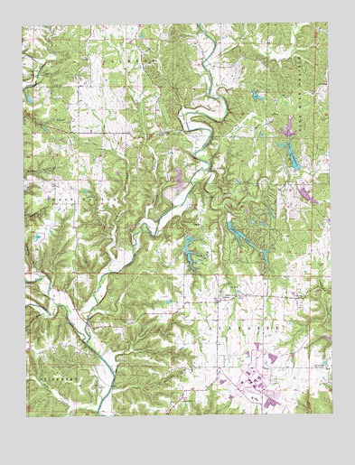
Reform, MO USGS Topographic Map
Click on map above to begin viewing in our Map Viewer.

This topographic map contains these locations and features:
Feature Name Type Latitude Longitude GNIS ID View Map
Ashland School (historical)SchoolN38.7842°W91.8127°742472View Map
Booth BranchStreamN38.7962°W91.8410°714541View Map
Brooks School (historical)SchoolN38.8634°W91.7841°742470View Map
Canyon LakeReservoirN38.8009°W91.7769°760889View Map
Canyon LakeReservoirN38.8077°W91.7878°766155View Map
Canyon Lake Lower DamDamN38.8117°W91.7918°765072View Map
Canyon Lake Upper DamDamN38.8017°W91.7785°760888View Map
Church of GodChurchN38.7881°W91.7899°715842View Map
Cow CreekStreamN38.8281°W91.8016°716406View Map
Craghead BranchStreamN38.8081°W91.8302°755544View Map
Crows Fork CreekStreamN38.7862°W91.8627°749545View Map
Dyers BranchStreamN38.8634°W91.8688°717226View Map
Gregory School (historical)SchoolN38.8595°W91.7505°742471View Map
Guerrart CemeteryCemeteryN38.8600°W91.8732°718914View Map
Halls CreekStreamN38.7512°W91.8466°750201View Map
Herring Lake DamDamN38.8417°W91.8335°762117View Map
Holiness CemeteryCemeteryN38.7884°W91.7877°719705View Map
Konrad DamDamN38.8384°W91.7785°762119View Map
Lake LochaweenoReservoirN38.8320°W91.7651°758304View Map
Lake Lochaweeno DamDamN38.8284°W91.7635°765073View Map
Lake Thunderbird Upper DamDamN38.8017°W91.8085°761635View Map
Lawrence DamDamN38.8367°W91.8718°762116View Map
Lawrence HollowValleyN38.7964°W91.8718°720844View Map
Lee Sualts DamDamN38.8034°W91.8702°764770View Map
Liberty CemeteryCemeteryN38.7548°W91.8124°720962View Map
Lost Canyon Lakes Section 25 Upper DamDamN38.8134°W91.7735°762121View Map
Lost Canyon Lakes Section 26 East DamDamN38.8117°W91.7785°762123View Map
Lost Canyon Lakes Section 26 West DamDamN38.8134°W91.7818°762122View Map
May BranchStreamN38.7825°W91.8655°750971View Map
Mirts Lake DamDamN38.8218°W91.8491°762118View Map
Muckler and Sieleisch LakeReservoirN38.8519°W91.7797°761391View Map
Muckler and Sielfleisch Lake DamDamN38.8517°W91.7818°761390View Map
Old Salem CemeteryCemeteryN38.7870°W91.7616°723783View Map
Oliver CemeteryCemeteryN38.7975°W91.7532°723811View Map
Pinch CreekStreamN38.8612°W91.8005°724363View Map
Pugh School (historical)SchoolN38.8662°W91.8491°742469View Map
Red Star School (historical)SchoolN38.8178°W91.8527°742468View Map
ReformPopulated PlaceN38.7653°W91.7791°741192View Map
Reform School (historical)SchoolN38.7647°W91.7829°743542View Map
Science Hill School (historical)SchoolN38.8120°W91.7846°742473View Map
Sielfleisch Lake Section 25 DamDamN38.8217°W91.7618°762763View Map
South Callaway Fire Protection District Station 5BuildingN38.7584°W91.8092°2621604View Map
Stinson CreekStreamN38.7731°W91.8505°752375View Map
Thunderbird LakeReservoirN38.8052°W91.8086°762125View Map
Thunderbird Lake DamDamN38.8084°W91.8085°762124View Map
ToledoPopulated PlaceN38.8406°W91.8182°741325View Map
Toledo School (historical)SchoolN38.8429°W91.8207°743515View Map
Winfield Investment Lake DamDamN38.8350°W91.7685°762120View Map
YucatanPopulated PlaceN38.8545°W91.7505°741377View Map

Note: Coordinates in the location and feature list above are referenced to NAD83 datum.


Copyright (C) 2008-2024 Ryan Niemi / Sunset Dynamics ... All Rights Reserved