TopoQuest Logo
Do you find TopoQuest useful?
Help keep TopoQuest running and adding new maps/features by donating!
Bitcoin:  19c7KJd3qBynnjoSw5npx9KScwjBe4ifkT
Litecoin:  LXs6TkuXGGXo1vDsWCkWVdjQX94eUKd6ui
Home View Maps Find Maps Find Places Resources & Links


Furman, South Carolina Topographic Map

USGS Map Title: Furman, SC
USGS Map MRC: 32081F2
DRG (GeoTIFF) Download: o32081f2.tif


Neighboring USGS Topographic Map Quads:


  Solomons Crossroads, SC  
32081G3
 

  Gifford, SC  
32081G2
 

  Hampton, SC  
32081G1
 

  Shirley, SC  
32081F3
 

  Furman, SC  
32081F2
 

  Grays, SC  
32081F1
 

  Brighton, SC  
32081E3
 

  Pineland, SC  
32081E2
 

  Calfpen Bay, SC  
32081E1


Map MRC Location:

N33°
W82°
N33°
W81°
H8 H7 H6 H5 H4 H3 H2 H1
G8 G7 G6 G5 G4 G3 G2 G1
F8 F7 F6 F5 F4 F3 F2 F1
E8 E7 E6 E5 E4 E3 E2 E1
D8 D7 D6 D5 D4 D3 D2 D1
C8 C7 C6 C5 C4 C3 C2 C1
B8 B7 B6 B5 B4 B3 B2 B1
A8 A7 A6 A5 A4 A3 A2 A1
N32°
W82°
N32°
W81°

Furman, SC USGS 1:24K Topographic Map Preview:
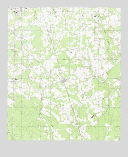
Furman, SC USGS Topographic Map
Click on map above to begin viewing in our Map Viewer.

This topographic map contains these locations and features:
Feature Name Type Latitude Longitude GNIS ID View Map
Bishop Grace ChurchChurchN32.6605°W81.2432°1232136View Map
Buckner SchoolSchoolN32.6960°W81.1304°1221086View Map
Crapsedale School (historical)SchoolN32.7460°W81.1795°1248887View Map
De LoachPopulated PlaceN32.6599°W81.1790°1247506View Map
Dixon Elementary SchoolSchoolN32.6743°W81.1757°1235310View Map
First Estill Baptist ChurchChurchN32.7490°W81.2391°2490232View Map
FurmanPopulated PlaceN32.6816°W81.1882°1247850View Map
Furman Fire Department Station 30BuildingN32.6823°W81.1824°2368281View Map
Furman Post OfficePost OfficeN32.6809°W81.1859°2489797View Map
Good Hope ChurchChurchN32.7163°W81.2345°1245765View Map
Hampton Fire Department Station 80BuildingN32.7429°W81.1521°2368435View Map
Horse Pond School (historical)SchoolN32.7399°W81.1429°1232169View Map
Johnson Big PondSwampN32.7018°W81.1879°1223599View Map
Jones PondReservoirN32.6968°W81.1598°1238762View Map
Lebanon ChurchChurchN32.6971°W81.2320°1223860View Map
NixvillePopulated PlaceN32.7429°W81.1520°1249880View Map
Nixville ChurchChurchN32.7499°W81.1479°1251709View Map
Nixville SchoolSchoolN32.7441°W81.1670°1225057View Map
Pine Savannah SchoolSchoolN32.6593°W81.1304°1225473View Map
Russel School (historical)SchoolN32.6960°W81.2420°1248894View Map
Sanctified Church (historical)ChurchN32.7416°W81.2095°1242291View Map
Sandy Drain Church (historical)ChurchN32.7246°W81.1718°1232212View Map
Sandy Drain School (historical)SchoolN32.7263°W81.1712°1248895View Map
ScotiaPopulated PlaceN32.6810°W81.2434°1226451View Map
Scotia School (historical)SchoolN32.6832°W81.2418°1235314View Map
Smith Store (historical)LocaleN32.7354°W81.1387°1248896View Map
South Carolina Noname 25011 D-2604 DamDamN32.6968°W81.1598°1238761View Map
South Carolina Noname 25013 D-2612 DamDamN32.6352°W81.1982°1238765View Map
StaffordPopulated PlaceN32.6702°W81.1648°1251023View Map
Stafford ChurchChurchN32.6674°W81.1659°1232220View Map
Steep Bottom (historical)Populated PlaceN32.6957°W81.2118°1235315View Map
Steep Bottom ChurchChurchN32.6993°W81.2173°1251037View Map
Steep Bottom PondSwampN32.6990°W81.2130°1232221View Map
StokesPopulated PlaceN32.6418°W81.1704°1251048View Map
Thankful ChurchChurchN32.7046°W81.2234°1251144View Map
Town of FurmanCivilN32.6812°W81.1877°2406533View Map
Town of ScotiaCivilN32.6805°W81.2433°2407298View Map
Zigzag BranchStreamN32.6724°W81.1351°1251539View Map

Note: Coordinates in the location and feature list above are referenced to NAD83 datum.


Copyright (C) 2008-2024 Ryan Niemi / Sunset Dynamics ... All Rights Reserved