TopoQuest Logo
Do you find TopoQuest useful?
Help keep TopoQuest running and adding new maps/features by donating!
Bitcoin:  19c7KJd3qBynnjoSw5npx9KScwjBe4ifkT
Litecoin:  LXs6TkuXGGXo1vDsWCkWVdjQX94eUKd6ui
Home View Maps Find Maps Find Places Resources & Links


Pineland, South Carolina Topographic Map

USGS Map Title: Pineland, SC
USGS Map MRC: 32081E2
DRG (GeoTIFF) Download: o32081e2.tif


Neighboring USGS Topographic Map Quads:


  Shirley, SC  
32081F3
 

  Furman, SC  
32081F2
 

  Grays, SC  
32081F1
 

  Brighton, SC  
32081E3
 

  Pineland, SC  
32081E2
 

  Calfpen Bay, SC  
32081E1
 

  Springfield North, GA  
32081D3
 

  Hardeeville NW, SC  
32081D2
 

  Tillman, SC  
32081D1


Map MRC Location:

N33°
W82°
N33°
W81°
H8 H7 H6 H5 H4 H3 H2 H1
G8 G7 G6 G5 G4 G3 G2 G1
F8 F7 F6 F5 F4 F3 F2 F1
E8 E7 E6 E5 E4 E3 E2 E1
D8 D7 D6 D5 D4 D3 D2 D1
C8 C7 C6 C5 C4 C3 C2 C1
B8 B7 B6 B5 B4 B3 B2 B1
A8 A7 A6 A5 A4 A3 A2 A1
N32°
W82°
N32°
W81°

Pineland, SC USGS 1:24K Topographic Map Preview:
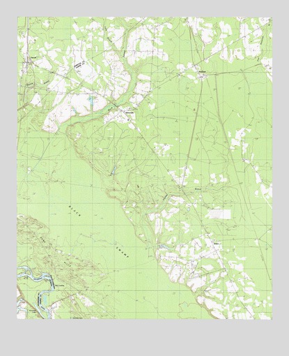
Pineland, SC USGS Topographic Map
Click on map above to begin viewing in our Map Viewer.

This topographic map contains these locations and features:
Feature Name Type Latitude Longitude GNIS ID View Map
Antioch ChurchChurchN32.5546°W81.1698°1244891View Map
Antioch School (historical)SchoolN32.5593°W81.1779°1241323View Map
Baxter PondReservoirN32.5285°W81.1832°1238742View Map
Bethel ChurchChurchN32.5382°W81.1576°1246773View Map
Bethel ChurchChurchN32.6016°W81.1701°1246774View Map
Black SwampSwampN32.5363°W81.2104°1246905View Map
Black SwampStreamN32.5721°W81.2290°1220778View Map
Black Swamp Baptist ChurchChurchN32.5866°W81.1995°1241328View Map
Black Swamp CemeteryCemeteryN32.5866°W81.2001°1241329View Map
Black Swamp CemeteryCemeteryN32.5954°W81.2437°1220780View Map
Bostic CemeteryCemeteryN32.5918°W81.2479°1220899View Map
Bowdens Hunting LodgeLocaleN32.5163°W81.2318°1241330View Map
Cedar Grove School (historical)SchoolN32.6205°W81.1312°1241332View Map
Church BranchStreamN32.5746°W81.2448°1221586View Map
CosbyPopulated PlaceN32.5818°W81.2482°1241337View Map
Cutoff Number 7-ABendN32.5191°W81.2443°1242490View Map
Cutoff Number 7aBendN32.5182°W81.2448°344222View Map
Cypress BranchStreamN32.5271°W81.1884°1221893View Map
Cypress PlantationLocaleN32.5482°W81.1623°1241339View Map
Cypress School (historical)SchoolN32.5652°W81.1362°1241340View Map
Dupies Ferry (historical)CrossingN32.5024°W81.2343°350214View Map
Dupies Ferry (historical)CrossingN32.5024°W81.2343°1241341View Map
GarnettPopulated PlaceN32.6063°W81.2454°1231306View Map
Garnett ChurchChurchN32.5955°W81.2429°1251705View Map
Garnett Post OfficePost OfficeN32.6065°W81.2429°1252075View Map
Garnett School (historical)SchoolN32.6043°W81.2473°1232155View Map
Good Hope ChurchChurchN32.5666°W81.1393°1245764View Map
Good Hope School (historical)SchoolN32.5641°W81.1346°1241350View Map
Highsmiths Sawmill (historical)LocaleN32.5832°W81.2476°1232166View Map
Jasper County Fire Department PinelandBuildingN32.6047°W81.1623°2368405View Map
Jasper Fire Department Station 44BuildingN32.5822°W81.1949°2368099View Map
Kennedy LakeLakeN32.5035°W81.2390°316384View Map
Long BranchStreamN32.6085°W81.1993°1224146View Map
Long Branch School (historical)SchoolN32.6016°W81.2259°1232182View Map
Mount Zion African Methodist Episcopal ChurchChurchN32.5948°W81.2319°1249701View Map
New LandingPopulated PlaceN32.5130°W81.2304°1231588View Map
Pine Land Hunting ClubLocaleN32.5713°W81.1823°1241550View Map
Pine Savannah BranchStreamN32.6210°W81.1259°1225471View Map
PinelandPopulated PlaceN32.6002°W81.1596°1231661View Map
Robertsville Baptist ChurchChurchN32.5780°W81.1898°1241560View Map
Robertsville School (historical)SchoolN32.5827°W81.1954°1241559View Map
RobertvillePopulated PlaceN32.5866°W81.1984°1250407View Map
Saint Johns ChurchChurchN32.6057°W81.2473°1226142View Map
Saint Mariah ChurchChurchN32.6205°W81.1321°1250583View Map
Saint Marys ChurchChurchN32.5346°W81.1562°1250607View Map
Sand HillsRidgeN32.5124°W81.2196°1250751View Map
Sisters CutBendN32.5180°W81.2351°323046View Map
Solomon TempleChurchN32.5921°W81.1884°1226747View Map
South Carolina Noname 27001 D-2587 DamDamN32.5285°W81.1832°1238741View Map
TarboroPopulated PlaceN32.5318°W81.1543°1231852View Map
Tarboro School (historical)SchoolN32.5405°W81.1593°1241574View Map
Tarboro Station (historical)LocaleN32.5335°W81.1321°1241575View Map
Titi School (historical)SchoolN32.6182°W81.1832°1241577View Map
Two Sisters Ferry (historical)CrossingN32.5143°W81.2323°350273View Map
Two Sisters Ferry (historical)CrossingN32.5143°W81.2323°1241579View Map

Note: Coordinates in the location and feature list above are referenced to NAD83 datum.


Copyright (C) 2008-2025 Ryan Niemi / Sunset Dynamics ... All Rights Reserved