TopoQuest Logo
Do you find TopoQuest useful?
Help keep TopoQuest running and adding new maps/features by donating!
Bitcoin:  19c7KJd3qBynnjoSw5npx9KScwjBe4ifkT
Litecoin:  LXs6TkuXGGXo1vDsWCkWVdjQX94eUKd6ui
Home View Maps Find Maps Find Places Resources & Links


Shirley, South Carolina Topographic Map

USGS Map Title: Shirley, SC
USGS Map MRC: 32081F3
DRG (GeoTIFF) Download: o32081f3.tif


Neighboring USGS Topographic Map Quads:


  Brier Creek Landing, GA  
32081G4
 

  Solomons Crossroads, SC  
32081G3
 

  Gifford, SC  
32081G2
 

  Blue Springs Landing, GA  
32081F4
 

  Shirley, SC  
32081F3
 

  Furman, SC  
32081F2
 

  Kildare, GA  
32081E4
 

  Brighton, SC  
32081E3
 

  Pineland, SC  
32081E2


Map MRC Location:

N33°
W82°
N33°
W81°
H8 H7 H6 H5 H4 H3 H2 H1
G8 G7 G6 G5 G4 G3 G2 G1
F8 F7 F6 F5 F4 F3 F2 F1
E8 E7 E6 E5 E4 E3 E2 E1
D8 D7 D6 D5 D4 D3 D2 D1
C8 C7 C6 C5 C4 C3 C2 C1
B8 B7 B6 B5 B4 B3 B2 B1
A8 A7 A6 A5 A4 A3 A2 A1
N32°
W82°
N32°
W81°

Shirley, SC USGS 1:24K Topographic Map Preview:
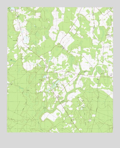
Shirley, SC USGS Topographic Map
Click on map above to begin viewing in our Map Viewer.

This topographic map contains these locations and features:
Feature Name Type Latitude Longitude GNIS ID View Map
Blake Plantation Pond Number One D-2607 DamDamN32.7468°W81.3682°1239539View Map
Breeler Field CemeteryCemeteryN32.6779°W81.3334°1220938View Map
Brighton School (historical)SchoolN32.6316°W81.2943°1232139View Map
Brighton School (historical)SchoolN32.6257°W81.2748°1248885View Map
Ceasars Camp PondLakeN32.7488°W81.3687°1221422View Map
Cypressvale School (historical)SchoolN32.6854°W81.3009°1251704View Map
Daley BranchStreamN32.6710°W81.3415°1227814View Map
Davis AirportAirportN32.6703°W81.3102°1251894View Map
Davis CemeteryCemeteryN32.6707°W81.3170°1221936View Map
Federal Correctional Institution EstillBuildingN32.7212°W81.2541°2489674View Map
Furman-Scotia DivisionCivilN32.6533°W81.2725°1938274View Map
Gracel Hill PlantationLocaleN32.6382°W81.2965°1232159View Map
Grant School (historical)SchoolN32.6838°W81.2640°1232158View Map
Hampton Fire Department Station 12BuildingN32.6628°W81.3140°2368283View Map
Haskell Barony SwampSwampN32.6521°W81.3473°1227807View Map
Heavenly Rest ChurchChurchN32.7107°W81.3109°1223109View Map
Hill CemeteryCemeteryN32.6599°W81.2923°1223180View Map
Hopewell ChurchChurchN32.6854°W81.3015°1246039View Map
Hopewell School (historical)SchoolN32.6818°W81.2876°1232168View Map
Horse Pond CemeteryCemeteryN32.6502°W81.2862°1223325View Map
Huntington Club (historical)LocaleN32.6391°W81.2976°1248890View Map
Jones Place (historical)LocaleN32.6949°W81.3568°1232176View Map
Kenyon Church (historical)ChurchN32.7341°W81.3590°1232177View Map
Lafitte PondReservoirN32.6984°W81.3240°1238779View Map
Long PondSwampN32.6965°W81.3689°1224179View Map
McKenzie PondReservoirN32.6677°W81.3254°1238767View Map
Millpond BranchStreamN32.6471°W81.3273°1246678View Map
Millpond CemeteryCemeteryN32.6854°W81.2851°1224576View Map
Morrison Store (historical)LocaleN32.7099°W81.3082°1248892View Map
Morrison Switch (historical)LocaleN32.7057°W81.3026°1232187View Map
Mount Pleasant ChurchChurchN32.6843°W81.2637°1224774View Map
Old Lawtonville CemeteryCemeteryN32.7174°W81.3632°1225197View Map
Ramseys PondReservoirN32.6768°W81.3382°1238777View Map
Saint Lukes ChurchChurchN32.7407°W81.3629°1250570View Map
Saint Marks Camp Ground (historical)LocaleN32.6857°W81.3026°1232206View Map
Saint Marks ChurchChurchN32.6596°W81.3154°1250588View Map
Sand Hill School (historical)SchoolN32.6852°W81.3193°1232210View Map
Sandhill ChurchChurchN32.6868°W81.3190°1250757View Map
ShirleyPopulated PlaceN32.6602°W81.3162°1226585View Map
Shirley School (historical)SchoolN32.6593°W81.3159°1232214View Map
Solomons CemeteryCemeteryN32.6791°W81.3282°1226748View Map
South Carolina Noname 25014 D-2593 DamDamN32.6660°W81.3268°1238766View Map
South Carolina Noname 25020 D-2611 DamDamN32.6768°W81.3382°1238776View Map
South Carolina Noname 25021 D-2598 DamDamN32.6968°W81.3232°1238778View Map
Sweet Branch School (historical)SchoolN32.7438°W81.2826°1232222View Map
Union CemeteryCemeteryN32.6904°W81.3287°1227283View Map
Union Church (historical)ChurchN32.6902°W81.3287°1251712View Map

Note: Coordinates in the location and feature list above are referenced to NAD83 datum.


Copyright (C) 2008-2025 Ryan Niemi / Sunset Dynamics ... All Rights Reserved